|
|

|
Visual Terrain Mapping for Mars Exploration
Investigators:
Clark F. Olson (PI), University of Washington, Bothell
Larry H. Matthies, Jet Propulsion Laboratory
Ron Li, Ohio State University
John R. Wright, Jet Propulsion Laboratory
Summary:
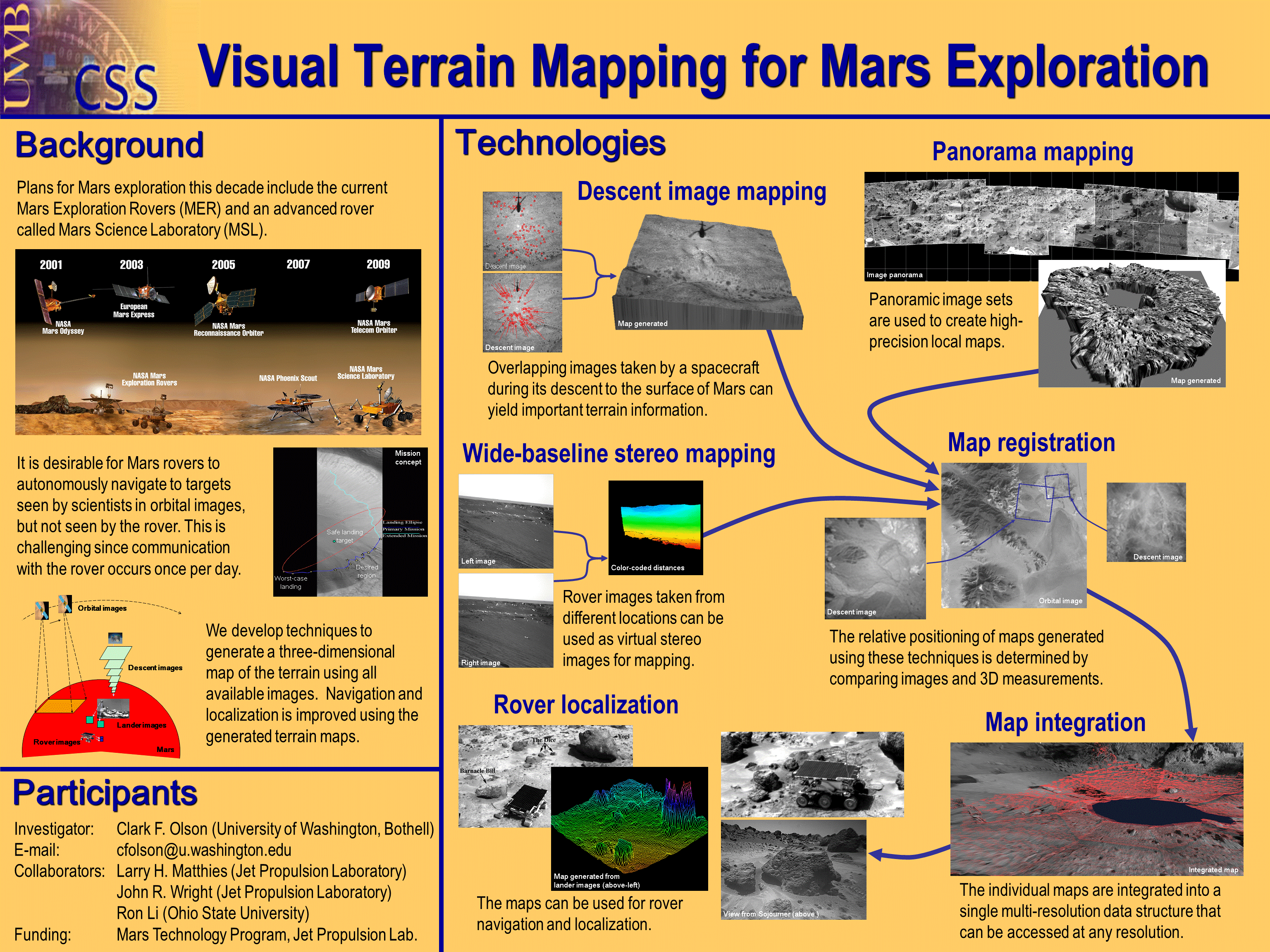
For a Mars rover capable of long-range mobility, it is highly desirable
to travel to science targets observed in orbital or descent imagery.
However, current rover technologies do not allow rovers to autonomously
navigate to distant targets with a single command. Since communication
with Mars rovers usually occurs only once per day, navigation errors can
result in the loss of an entire day of scientific activity. In order
to improve long-range navigation capabilities, we will map the traverse
and target locations using 3D data generated from all available images,
including surface images from the lander and/or rover, descent images from
the lander, and orbital images from current and future Mars orbiters.
LIDAR range data from rovers and/or landers can also be integrated with
this methodology. Initial mapping with descent and orbital images will
occur on the ground and maps will be uplinked to the rover. The rover will
perform additional mapping using conventional and wide-baseline stereo
techniques to generate high-resolution local maps. This will allow
on-board localization of the rover position with respect to the descent
and orbital image landmarks. In addition to improving rover localization
capabilities, the maps will be useful for planning and visualization for
ground operations.
A pictorial representation of the overall process can be found by clicking on the icon.
 . .
Related publications:
Clark F. Olson and Habib Abi-Rached,
Wide-Baseline Stereo Vision for Terrain Mapping,
Machine Vision and Applications, 21(5): 713-725, August 2010.
Abstract ,
Download (1073 K)
Clark F. Olson, Larry H. Matthies, John R. Wright, Rongxing Li, and Kaichang Di,
"Visual Terrain Mapping for Mars Exploration,"
Computer Vision and Image Understanding, 105(1): 73-85, January 2007.
Abstract ,
Download (2618 K)
Yalin Xiong, Clark F. Olson, and Larry H. Matthies,
"Computing Depth Maps From Descent Images,"
Machine Vision and Applications, 16(3):139-147, May 2005.
Abstract ,
Download (1549 K)
Clark F. Olson and Habib Abi-Rached.
Wide-Baseline Stereo Experiments in Natural Terrain.
In Proceedings of the 12th International Conference on Advanced Robotics, pages 376-383, July 2005.
Abstract ,
Download (2248 K)
Clark F. Olson,
Habib Abi-Rached, Ming Ye, and Jonathan P. Hendrich.
"Wide-Baseline Stereo Vision for Mars Rovers."
In Proceedings of the IEEE/RSJ International Conference on Intelligent Robot
s and Systems, pages 1302-1307, October 2003.
Abstract ,
Download (224 K)
Clark F. Olson, Larry H. Matthies, Yalin Xiong, Ron Li, Fei Ma, Fengliang Xu,
"Multi-resolution Mapping Using Surface, Descent, and Orbital Images,"
Proceedings of the 6th International Symposium on Artificial
Intelligence, Robotics and Automation in Space, 2001.
Abstract
|