Bathymetry collected on one page!

I have bathymetry plots scattered all through these pages, and damned if I can find them when I need them. As a result, I keep remaking them, which is stupid. So just collect them here (most of them are repeated views of the same thing over and over).

  1. Large-scale overviews:
    1. SW Pacific (B/W) (etopo20)   (pdf version)
    2. SW Pacific (color) (etopo5)
    3. S Pacific (etopo20)

  2. New Caledonia-Vanuatu-etc region:
    1. Vanuatu - NC and south (B/W) (etopo20)
    2. NC and northern reef (etopo2)
    3. Solomons to Vanuatu to NC (etopo2)
    4. NC-Vanuatu (etopo2)
    5. Tuamotus (etopo20)

  3. Australia east coast and Gulf of Papua:
    1. Gulf of Papua (S&S 2-minute)
    2. Queensland Plateau overview
    3. CARS schematic circulation over bathymetry
    4. Bathymetry and CARS ug along the east coast of Australia

  4. Solomon Sea region:
    1. Solomon Sea with island names
    2. S&S 140°E-164°E, 12°S-0°
    3. Bathymetry around the Solomon Islands: 
      etopo2   Smith & Sandwell    Include Solomon Strait   Include Solomon Sea   Correct scaling, with names
    4. Solomon Islands straits and sills:
      1. Map showing sill section location   Include eastern path through Malaita
      2. Sill depths through the Solomon Islands   (Include eastern path)
      3. Cross-sectional area of the straits
      4. Bathymetry details in the southern Solomon Islands: 1   2

  5. Bathymetry around the tip of PNG (Note: "Milne Bay Passage" is really Jomard Entrance): 
    1. Large region   Detail   Finer detail   Finer than that (Jomard Entrance)
    2. Profiles across the Milne Bay passage   Compare Lombok St   Overlay
    3. Smith and Sandwell bathymetry: Jomard Entrance   Profiles   Compare Lombok (map)Lombok profiles   Overlay
    4. Compare 1 vs 2-minute S&S product for Milne Bay region     Detail near Tagula and Rossel

  6. Trobriand sill details:
    1. Map showing Trobriand-Woodlark-BudiBudi sill section
    2. Sill depths along the ridge    Running area of the straits

  7. Bathymetry around Milne Bay, PNG (Scanned nautical charts)
    1. Woodlark archipelago:  
      1. Kiriwina to BudiBudi (Laughlan):   Large-scale     Detail     Woodlark-BudiBudi
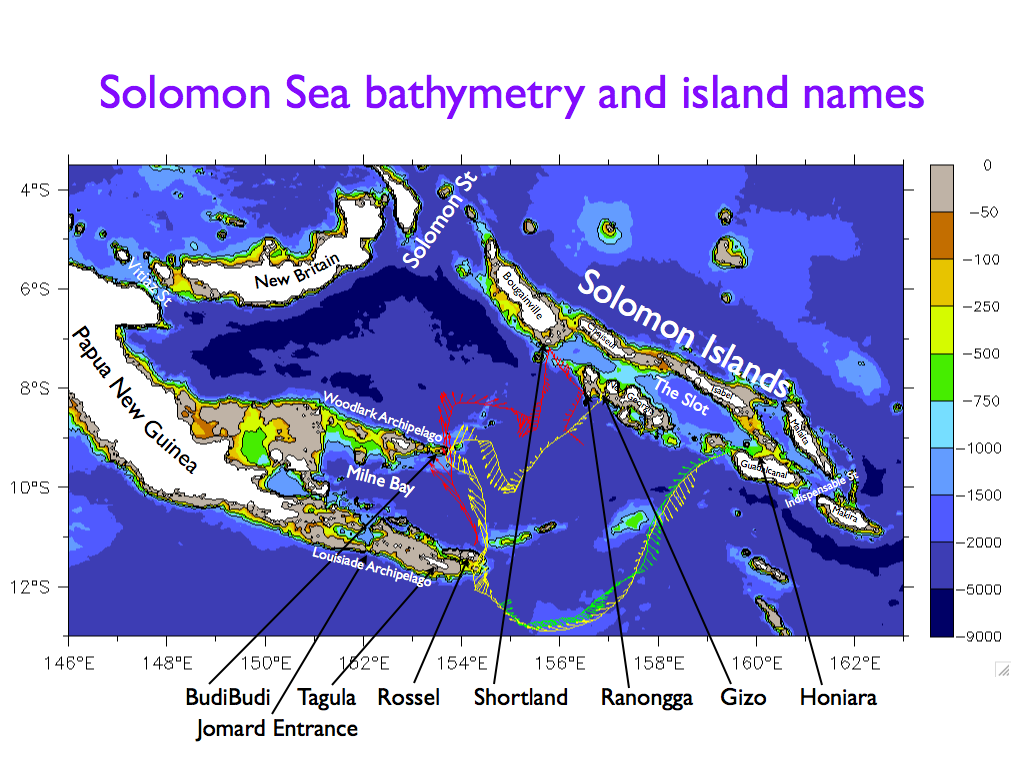
      2. Fine-scale charts:   Kiriwina-Marshall Bennett (fathoms)     to Woodlark
        (=> Kiriwina-Woodlark passage is about 140km wide, sill 300-400m deep, broken by 3 island groups)
        (=> Woodlark-BudiBudi passage is less than 8km wide, probably shallow)
    2. Louisiades:   Louisiades general
      1. Jomard Entrance region     Jomard detail
        (=> Jomard Entrance has 2 passages: 5.2km and 3.5km wide, 18km long, 200-250m deep)
      2. Rossel and Tagula     Fine-scale (in fathoms)
        (=> the Rossel-Tagula passage is about 50km long, 13.6km wide, 500-600m deep)


Return to main page

Other pages:

horizontal black line
NOAA logo Dr. William S. Kessler
NOAA / PMEL / OCRD
7600 Sand Point Way NE
Seattle WA 98115 USA
Tel:   206-526-6221
Fax:  206-526-6744
E-mail:  william.s.kessler@noaa.gov
See also:    Kessler home page        Kessler publications         PMEL home page