
Urban Traffic Modeling with Mobile Sensing
What is Mobile Sensing?
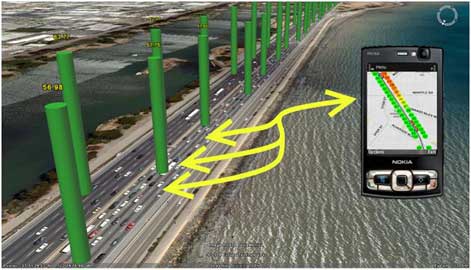
Advances in wireless communications have prompted the rapid deployment of mobile traffic sensors that are able to move along with the flow they are monitoring. Mobile sensors provide an alternative to fixed-location sensors, such as loop detectors, that currently dominate the traffic detection systems. Broadly speaking, mobile traffic sensors include any monitoring or data collection system with a device that can move with the traffic flow. They include probe vehicles (such as those equipped with Electric Toll Collection (ETC) tags), cellular phones, portable global positioning system (GPS) devices (like GPS-enabled smart phones or navigation systems), and Bluetooth Mac Address Matching (BMAM), among others. When Connected and Automated Vehicles (CAVs) are widely deployed, every equipped vehicle will be a mobile sensor, which will dramatically increase the market penetration of mobile sensing data. Most mobile sensors need to communicate with satellites (GPS), cellular towers (cell phones), or dedicated roadside infrastructure (ETC, Connected Vehicles, BMAM) to derive the position of the mobile component, its speed, and other relevant information. As shown in the figure below, mobile sensing data are distinctly different from fixed-location sensor data: the former can provide (almost) continuous data spatially and temporally albeit for a sample of the traffic flow, while the latter can provide data for the entire traffic flow but only at discrete locations and time instants.
What have we done (or are working on)?
Mobile traffic sensors (such as GPS or cellular phones) provide an alternative way to traditional fixed-location sensors (such as loop detectors) for traffic data collection, freeway or arterial performance measurements, traffic state estimation, and traffic control and optimization. Under the collaborations with the University of California, Berkeley, Nokia Palo Alto Research Lab, and Navteq, we worked on modeling GPS-equipped cellular phones as freeway traffic probes.
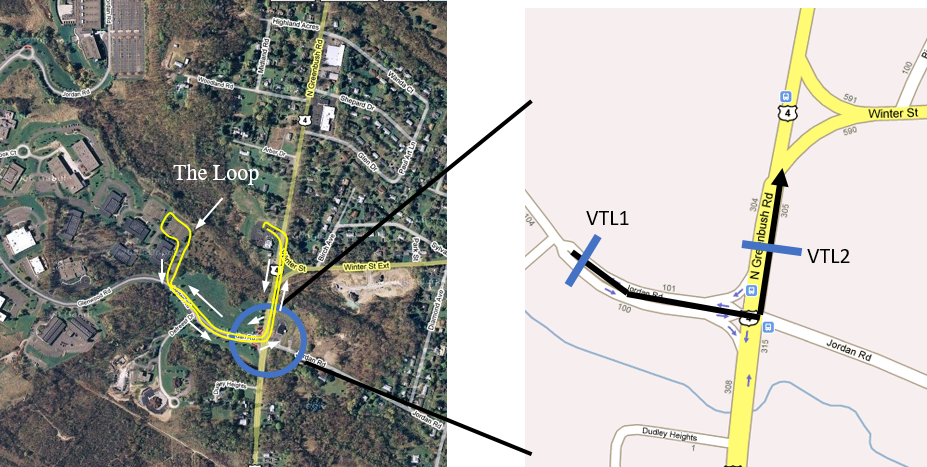
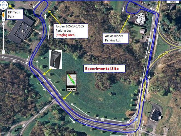
Sponsored by NSF, USDOT, Region 2 Transportation Research Center, and TransInfo Tier 1 Transportation Research Center, we also worked on new schemes to co-design mobile data collection / modeling and privacy protection, real time arterial performance measurements (such as delays, queue lengths, and emissions) and urban freight delivery performance measuremetn (such as the number of stops, delivery times, etc.) using mobile data, and techniques to fuse mobile data and fixed-location data. We have been conducting experiments for mobile data collection, and model testing and validation in the Albany, NY area. Click here for an illustration of the data collection.
We are now working on using MS and other data sources, collectively called "big data", for reliable estimation / prediction of large-scale traffic performance and travel patterns, as well as the issues associated with such estimation/prediction. Our initial investigation so far revealed that (i) big data are very useful as they are revolutionizing many aspects of transportation; (ii) big data are usually generated for their primary purposes, which are often not for transportation, resulting in representativeness issues; (iii) one should be cautious when inferring behavioral and travel patterns such as the origin-destination (OD) demands from big data.
Mobile-data-based modeling methods
The methods need to properly integrate data analytics techniques (i.e., learning and/or optimization models) with transportation principles and processes (i.e., physical models), resulting in model-based (or knowledge-based) learning/optimization methods. Depending on the specific purposes and applications, the way how they integrate may vary. In rare cases, even one of the two may work very well (and no need to integrate the other). But in general, the integration will work the best in terms of reducing the model complexity and computational effort, and /or of improving estimation/prediction accuracy and reliability.
For transportation applications, pure data-driven methods that ignore the physical process of transportation systems, may not work well. This is because data, no matter how big it is, can only reflect the physical processes and laws of transportation (sometimes can help discover new processes and laws), but cannot fundamentally change them. Therefore, data-driven methods need to respect/integrate well-established physical models. This is particularly critical for transportation and other engineering applications, for which well-established physical models already exist.
The following are examples of mobile sensing based research topics and results iUTS team has conducted in the past.
Co-Design of Mobile Data Collection/Modeling Methods and Privacy Protection Schemes
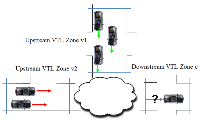
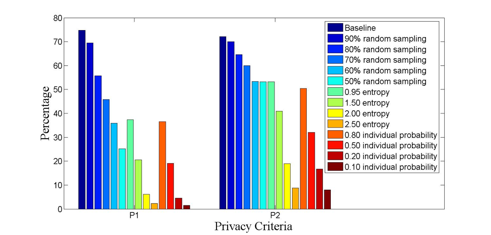
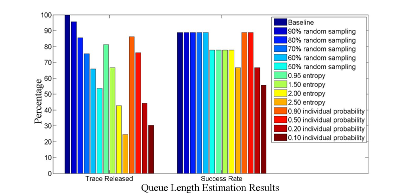
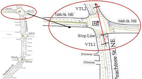
We collaborated with location privacy experts to co-design MS data collection methods to (i) provide privacy guarantees of the users who contributed the data; (ii) ensure that the collected privacy-preserving data can be used for transportation modeling applications. We started with the virtual trip line (VTL) concept to collect MS data (mainly travel times) at pre-defined and virtual geo-locations. This reduces the likelihood of a vehicle being tracked. Based on the VTL concept that works for a single intersection, we further developed the VTL-zone based method to collect only vehicle traces within a VTL-zone and discard traces out of these zones. Furthermore, we developed filtering algorithms to remove some of the collected traces if the possibility of the vehicles being tracked is high. The resulting traces are shown to provide better privacy guarantee while at the same time only degrade the application performance slightly.

Real-Time Queue Length Estimation of Signalized Intersections using sample travel times:
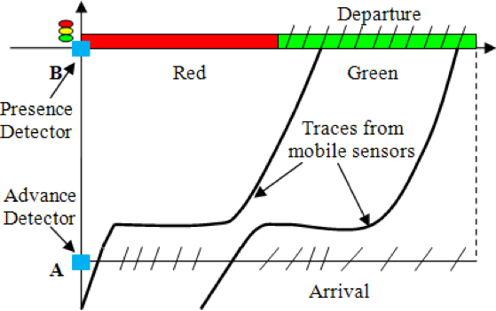
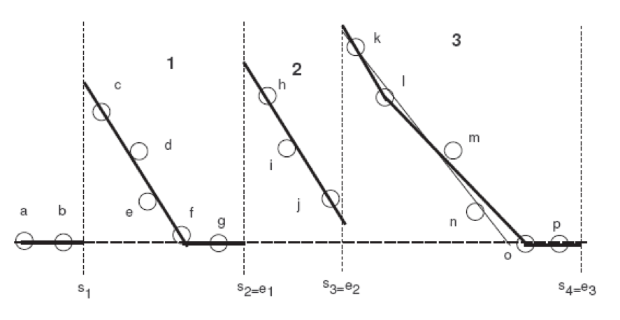
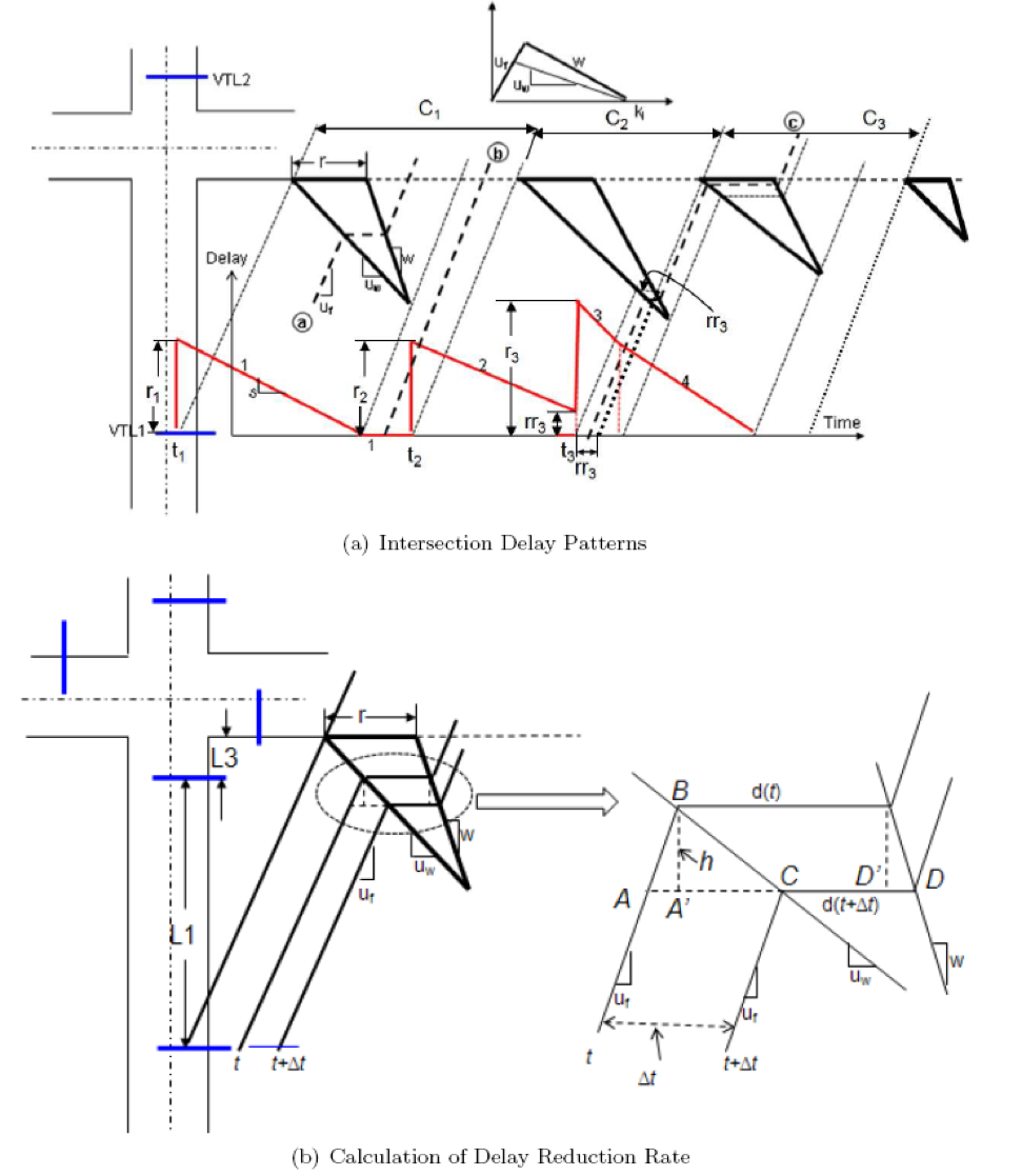
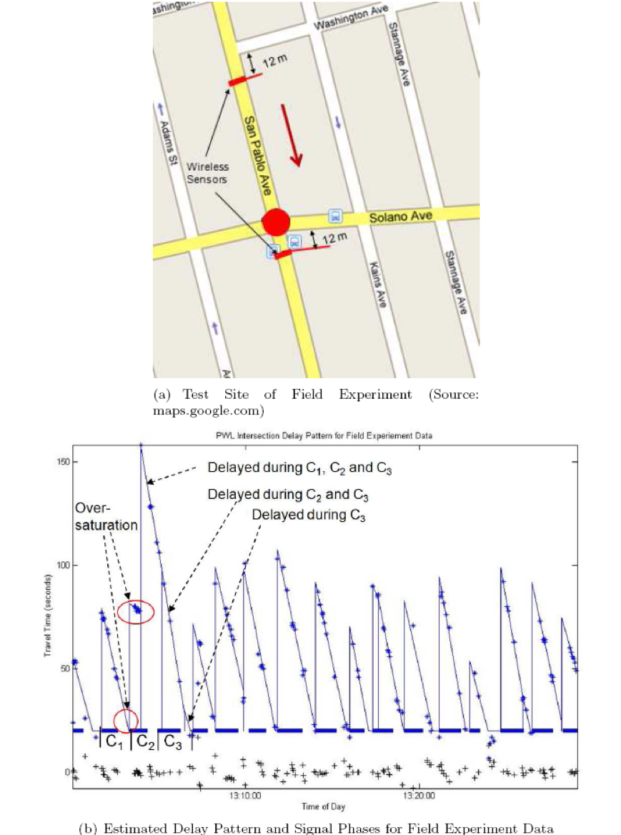
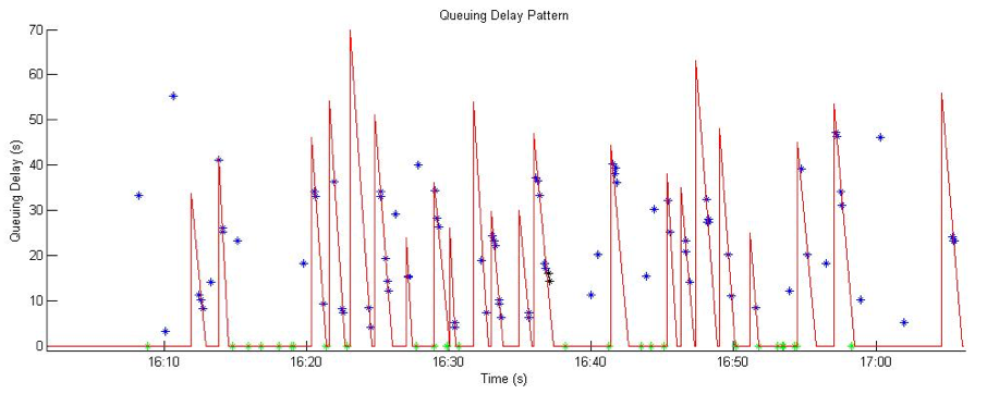
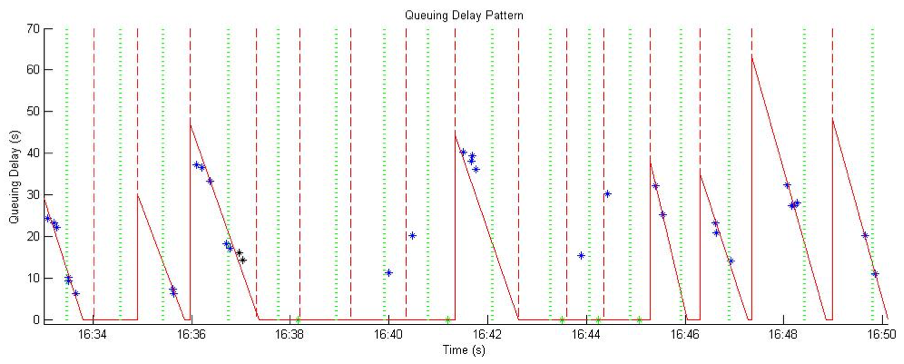
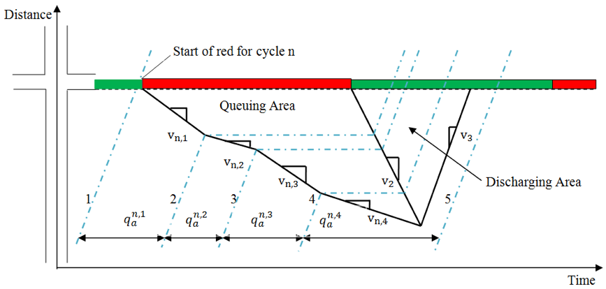
MS data is fundamentally different from traditional fixed-location data (such as loop data) since MS data usually represent a sample of the entire traffic flow and do not directly contain information such as volume or occupancy. As a result, conventional methods that use such information cannot be readily applied to MS data. Our first paper on using MS data for arterial traffic modeling is to estimate the delay pattern of a signalized intersection. Delay pattern describes the delay a vehicle might have experienced if it had passed the intersection at a particular time. Instead of using volume or occupancy data as conventionally done in the past, we proposed to use sample travel times from MS. This is essentially to use measured data (delays or travel times) to estimate the underlying delay pattern. Rather than treating the estimation as a pure data-driven problem, we proposed a method that integrates both data-driven approaches and transportation principles. We first discovered that, by applying the well-established shock-wave theory of traffic flow, the delay pattern of a signalized intersection (roughly) follows a linear pattern under certain arrival assumptions. This allows us to apply rather simple data-driven estimation methods to fit the linear pattern from measured MS data. The research results show several important findings. First, sample travel times from MS can be used for urban traffic modeling, similarly as volume/occupancy data in conventional traffic modeling methods. Secondly, MS data based modeling approach should properly integrate data-driven approaches (such as optimization and / or statistical learning methods) and transportation/traffic knowledge and principles. The former helps us better deal with the data to produce robust results, while the latter describes the underlying physics of traffic flow which the data should respect. Our following investigations on other transportation applications applied the same idea, including queue length estimation, signal timing estimation, vehicle classification, emission estimation, among others.
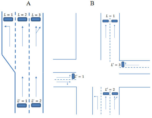
Vehicle index and queue distribution via stochastic modeling of intersection traffic flow
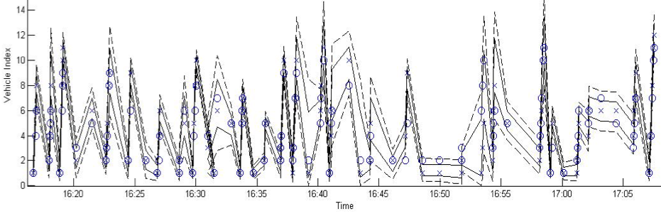
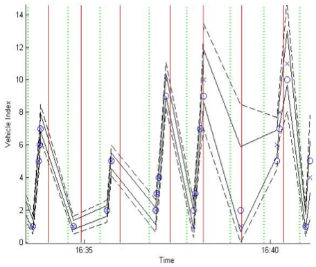
Urban traffic flow is stochastic by nature due to various disruptions. We developed stochastic learning models such as Bayesian networks models to estimate a sample vehicle’s position in the entire traffic flow, based on which to derive the distribution of the cycle-by-cycle queue profile of a signalized intersection. The model may also help derive the distribution of the cycle by cycle traffic volumes. Both the queue and traffic volume information are useful input to advanced signal control algorithms under connected automated vehicles (CAVs).
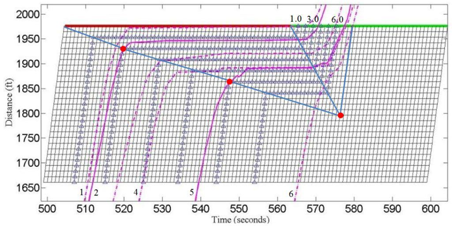
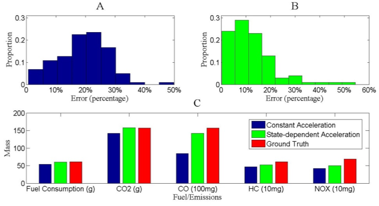
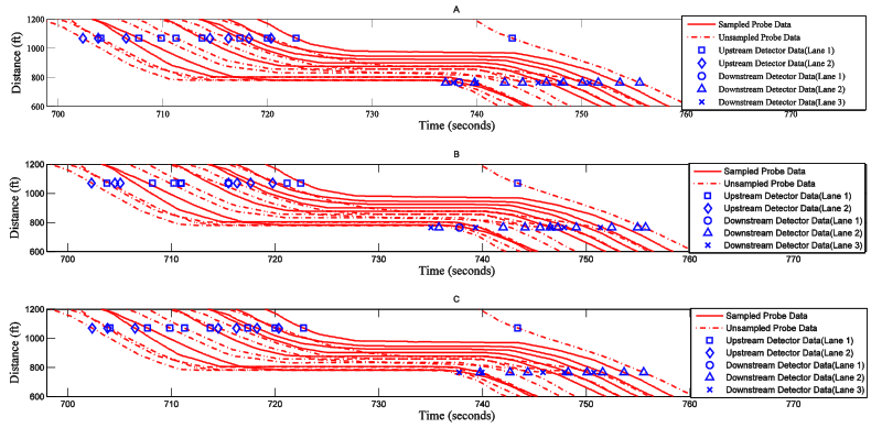
Vehicle trajectories and emissions
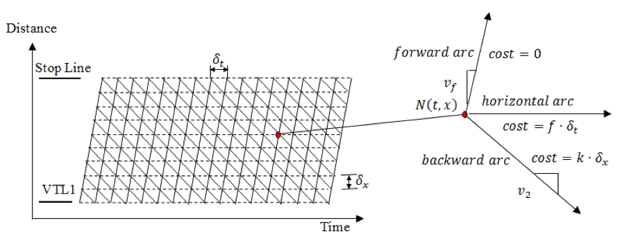
We developed methods to estimate vehicle trajectories of the entire traffic flow and based on which to provide accurate estimation of fuel consumption and emissions. The methods integrate both traffic knowledge (such as the variational formulation based traffic flow theories) and learning optimization methods for accurate and robust results.
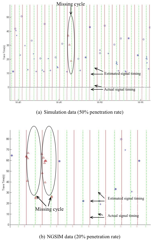
Signal timing estimation
We developed methods to estimate the signal timing (green and red time durations) of a signalized intersection using sample travel times. This is an perfect example to show the value of the integration of physical models (i.e., the vehicle queuing characteristics and signal timing characteristics) and data analytics methods (i.e., quadratic optimization)
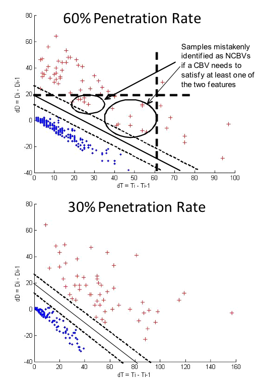
Vehicle classification
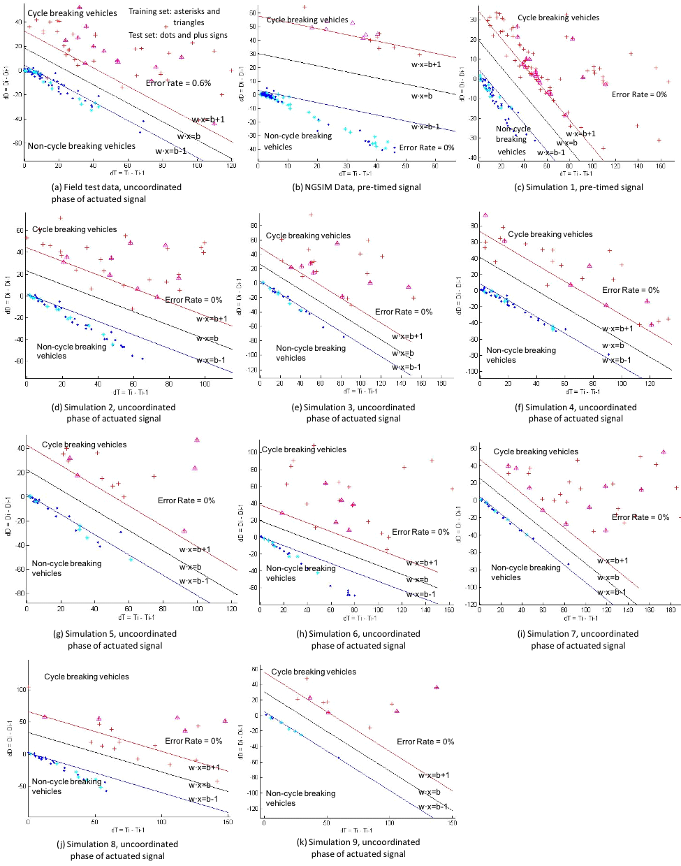
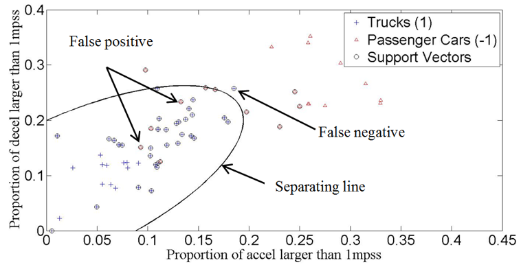
Using MS data (detailed vehicle traces), we developed acceleration-based vehicle classification methods that can distinguish cars from trucks and small trucks from big trucks. The methods are based on support vector machines (SVM) and use a number of features, most critically the acceleration/deceleration characteristics of the vehicles.
Urban freight delivery performances
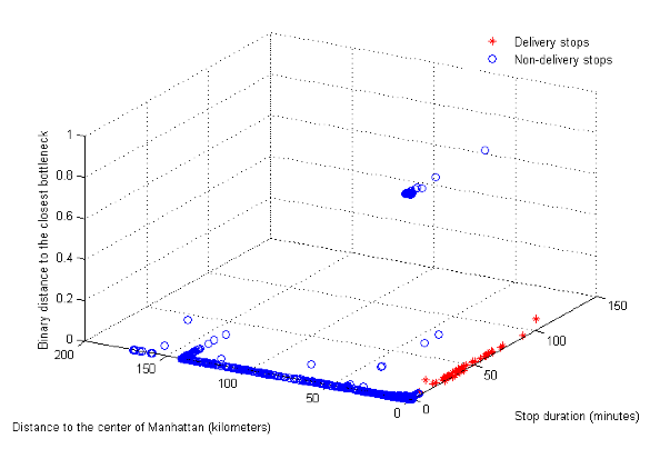
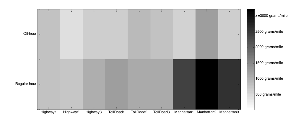
We worked with Dr. Jose Holguion-Veras from the Rensselaer Polytechnic Institute and colleagues from the New York City Department of Transportation, sponsored by the FHWA, for pilot and implementation of off hour delivery (OHD) polices in NYC. Our iUTS team was in charge of using MS data for assessing the performance of urban deliveries and evaluating innovative freight policies such the freight OHD strategies. We developed machine learning based methods, with the help of traffic knowledge (delivery behavior and traffic bottlenecks etc.), to identify delivery stops and defined metrices for delivery performances and OHD policies. We discovered that (i) mobile data are useful for assessing the freight delivery performances; (ii) noticeable discrepancies may exist between the performances derived from MS data and the ground-truth performances since MS data lack behavior information, i.e, they are good at showing “what happened” but not “why that happened”; (iii) innovative policies such as OHD are beneficial for reducing urban congestion, energy consumption, and emissions.
Data fusion methods
We developed learning based methods for fusing MS data with other data sources such as loop data.
Publications
- Sun, Z., Ban, X., 2017. Identifying multiclass vehicles using GPS data. Journal of Intelligent Transportation Systems, Accepted.
- Hao, P.*, and Ban, X., 2015. Long queue estimation using short vehicle trajectories for signalized intersections. Transportation Research Part B, 82, 54-73.
- Sun, Z.*, Ban, X., Hao, P.*, Yang, D., 2015. Trajectory-based vehicle energy/emission estimation for signalized arterials using mobile sensing data. Transportation Research Part D 34, 27-40.
- Yang, X.*, Sun, Z.*, Ban, X., Holguin-Veras, J., 2015. Urban freight delivery stop identification using GPS data. Transportation Research Record 2411, 55-61.
- Hao, P.*, Ban, X., Yu, J.W., 2015. Kinematic equation based vehicle queue location estimation method for signalized intersections using mobile sensor data. Journal of Intelligent Transportation Systems 19(3), 256-272.
- Hao, P., Sun, Z., Ban, X., Guo, D., and Ji, Q., 2014. Cycle by cycle intersection queue length distribution estimation using sample travel times. Transportation Research Part B 68, 185-204.
- Yang, X.*, Sun, Z.*, Ban, X., Holguin-Veras, J., 2014. Urban freight delivery stop identification using GPS data. Transportation Research Record, in press.
- Hao, P.*, Ban, X., 2014. Platoon based arterial corridor route travel time estimation using sample travel times. In Proceedings of the 93rd Annual Meeting of Transportation Research Board, Washington, DC.
- Yang, X.*, Sun, Z.*, Ban, X., Wojtowicz, J., Holguin-Veras, J., 2014. Urban freight performance measurement using GPS data. In Proceedings of the 93rd Annual Meeting of Transportation Research Board, Washington, DC.
- Hao, P.*, and Ban, X., 2013. Long queue estimation using short vehicle trajectories for signalized intersections. In Proceedings of the 92nd Annual Meeting of Transportation Research Board, Washington, DC.
- Sun, Z.*, and Ban, X., 2013. Vehicle classification using GPS Data. Transportation Research Part C 37, 102-117.
- Sun, Z.*, and Ban, X., 2013. Vehicle trajectory reconstruction for signalized intersections using mobile traffic sensors. Transportation Research Part C 36, 268-283.
- Sun, Z.*, Zan, B., Ban, X., and Gruteser, M., 2013. Privacy protection method for fine-grained urban traffic modeling using mobile sensors. Transportation Research Part B 56(1), 50-69.
- Hao, P.*, Sun, X.*, Ban, X., Guo, D.*, and Ji, Q., 2013. Vehicle index estimation for signalized intersections using sample travel times. Transportation Research Part C 36, 513-529.
- Richardson, E.*, Ban, X., and Holguin-Veras, J., 2013. Identifying and classifying freight trip stops from GPS data. In Proceedings of the 92nd Annual Meeting of Transportation Research Board, Washington, DC.
- Holguin-Veras, J., Torres, C.A.*, and Ban, X., 2013. On the comparative performance of urban delivery vehicle classes. Transportmetrica A: Transport Science 9(1), 50-73.
- Zan, B.*, Sun, Z., Gruteser, M., Ban, X., 2013. Linking anonymous location traces through driving characteristics, In Proceedings of the 3rd ACM conference on Data and Application Security and Privacy (CODASPY).
- Hoh, B., Iwuchukwu, T., Jacobson, Q., Gruteser, M., Bayen, A., Herrera, J.C., Herring, R., Work, D., Annavaram, M., and Ban, X, 2012. Enhancing Privacy and Accuracy in Probe Vehicle Based Traffic Monitoring via Virtual Trip Lines. IEEE Transactions on Mobile Computing, 11(5), 849-864.
- Holguin-Veras, J., Jaller, M., Destro, L., Ban, X., and Lawson, C., 2011. Freight generation, freight trip generation, and the perils of using constant trip rates. Transportation Research Record 2224, 68-81.
- Hao, P., Ban, X., Bennett, K., Ji, Q., and Sun, Z., 2012. Signal timing estimation using intersection travel times. IEEE Transactions on Intelligent Transportation Systems, 13(2), 792-804.
- Ban, X., and Gruteser, M., 2010. Mobile sensors as traffic probes: addressing transportation modeling and privacy protection in an integrated framework. In Proceedings of the 7th International Conference on Traffic and Transportation Studies, Kunming, China .
- Ban, X., Hao, P.*, Sun, Z.*, 2011. Real time queue length estimation for signalized intersections using sample travel times from mobile sensors. Transportation Research, Part C, 19(6), 1133-1156
- Sun, Z., and Ban, X., 2010. Vehicle trajectory reconstruction for signalized intersections using variational formulation of kinematic waves. Presented at the 90th Transportation Research Board Annual Meeting.
- Hao, P.*, and Ban, X., 2010. Estimation of queue position for signalized intersections using sample travel times from mobile sensors. Presented at the 90th Transportation Research Board Annual Meeting.
- Ban, X., and Gruteser, M., 2012. Towards fine-grained urban traffic knowledge extraction using mobile sensing . To be presented at the ACM SIGKDD International Workshop on Urban Computing , Beijing, China, August 12, 2012.
- Herrera, J.C., Work, D.B., Herring, R., Ban, X., and Bayen, A., 2010. Evaluation of traffic data obtained via GPS-enabled mobile phones: the Mobile Century field experiment. Transportation Research Part C, 18(4), 568-583.
- Ban, X., Herring, R., Hao, P.*, and Bayen, A., 2009 Delay pattern estimation for signalized intersections using sampled travel times.Transportation Research Board 2130, 109-119.
- Hoh, B., Gruteser, M., Herring, R., Ban, X., Work, D., Herrera, J., and Bayen, A., 2008. Virtual trip lines for distributed privacy-preserving traffic monitoring. In Proceedings of The Sixth Annual International conference on Mobile Systems, Applications and Services (MobiSys 2008).
Notes: * indicates graduate students Dr. Ban has advised at UW and RPI