Table of Contents
Abstract
Interferometric synthetic aperture radar (InSAR) data collected over three winters are used to determine if pre-failure movements of landslides are detectable along the North Fork Stillaguamish River Valley, Washington. Large landsliding is common to the study region, and poses considerable human and societal risk. C-band ENVISAT and ERS2 data are found to provide insufficient coherence for interferometry at the study site. L-band data, being less sensitive to small vegetation changes between scenes, produced one coherent interferogram from the four scenes collected, with temporal decorrelation preventing further interferogram creation. This work indicates that for consecutive, like-polarized, ALOS L-band interferograms, landslide detection may be possible near or at the study site, but additional geometric constraints limit the applicability of this approach.
Introduction
Large precipitation-induced landslides pose a significant risk to human safety and existing infrastructure in the state of Washington, as shown in the recent March 22, 2013 Steelhead Haven landslide tragedy. Previous field-based studies (e.g. Petley et al., 2002; Bozzano et al., 2014) have shown landslide pre-failure movement and velocity time histories are able to predict time of failure. Building on these relationships, Mazzanti et al. (2012) present a framework in which landslide failure could be predicted using pre-failure displacement relationships using InSAR data. Preliminary results are shown here for detecting pre-failure movements of known landslides in western Washington, and to explore interferometry as a means of landslide early warning or detection. Active slides along the North Fork Stillaguamish River valley were explored during the winter prior to known landsliding dates in 2006 and 2011.
Motivation of Work
Studies of past landsliding and susceptibility to future landsliding have shown the extreme pervasiveness of these events locally (Haugerud, 2014; Miller, 1999). On March 27, 2013 The Whidbey Island slide displaced ~150,000m3, reactivating an older landslide complex and endangering 20 homes (DNR, 2013). The more recent, March 22, 2014, Steelhead Haven slide displaced 7.6 million cubic meters of material, buried 600m of highway, caused an estimated $50M in damages and took the lives of 43 individuals (Keaton et al., 2014). Steelhead Haven was a continuation of frequent landsliding at the Hazel site near Oso, Washington, where slides in 2006, 1988, and 1967 have all partially dammed the North Fork Stillaguamish.
Current annual precipitation over the western half of Washington is approximately 1.25m, falling mostly from October through March, and is expected to rise statewide in the coming decades as a result of climate change (Elsner et al., 2010). In our current climatic regime, precipitation-induced landslides present a significant risk in our region, and increases in precipitation intensity or duration as a result of climate change will only increase this risk.
Background
Landsliding
In this work, the movements of large, deep-seated, landslides are targeted. Deep-seated slides or slumps in sands and fine-grained material tend to have a strong rotational component of motion (see Figure 1). Overall motion in the upper portion of the slide, the zone of depletion, is predominantly downward, with a small translational component. Movement in the lower zone of accumulation will be a combination of upward and lateral motion. A slowly developing, or pre-failure creeping, deep rotational landslide should produce a distinct pattern of line of sight (LOS) deformation in InSAR scenes, roughly shaped as a rounded hourglass, with range increases in the upper portion and a more diffuse range decreasing zone below.
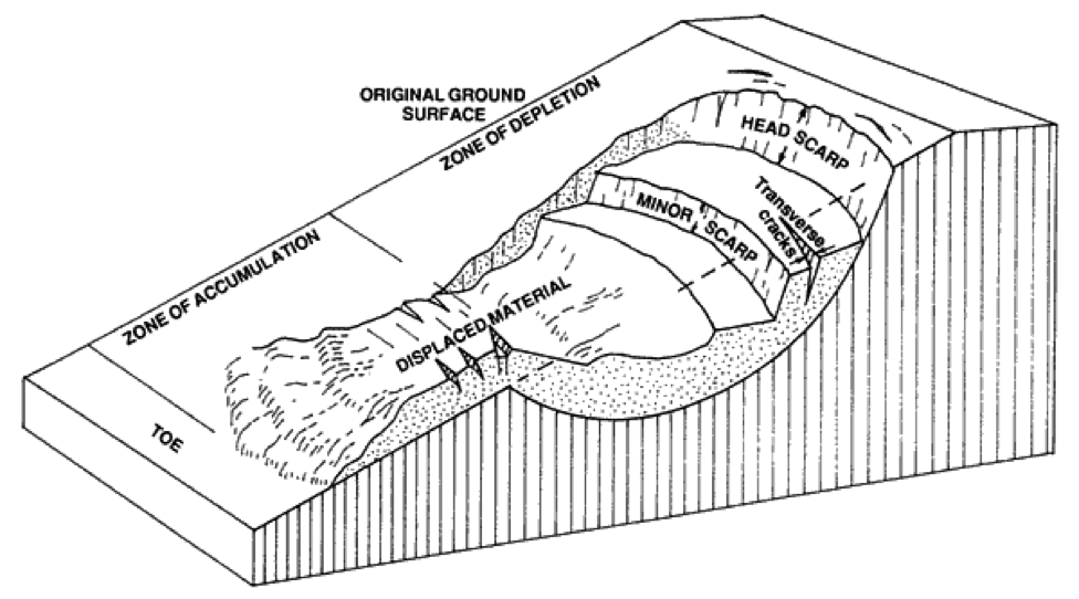
Figure 1, Diagram of slump-earth flow failure, modified from Varnes (1973). Image via http://www.for.gov.bc.ca/hfd/pubs/docs/sil/Sil411/A4110025.htm
Field observations have noted that rather than the rigid body failure idealized in most models, large deep-seated landslides are characterized by slow, increasing strain rates up to a threshold point, at which rapid failure occurs (e.g. Mazzanti et al., 2012; Crosta and Agliardi, 2003; Bozzano et al., 2011). This strain-acceleration behavior is well demonstrated in Figure 2 from Petley et al. (2002), which plots inclinometer data at four points along a rotational failure plane. These test data show a strong ground deformation signal, with steady displacements of ~7.5cm/mo at the toe of the slope (point 10) over the last 400 days prior to failure.

Figure 2. Inclinometer data showing cumulative displacement along the Selborne landslide test site, cumulative displacement in cm. From Petely et al. (2002)
Interferometry has been used in a wide range of locations recently to identify new landslides or monitor deformation of known slides (e.g. Roering et al., 2009; Zhao et al., 2012; Liu et al., 2011; Jebur et al., 2013). In most studies, ALOS data, collected using 24cm L-band wavelengths, is preferred to 5.6cm C-band (ERS1/2, ENVISAT, RADARSAT-1/2) systems given its relative insensitivity to vegetation and perpendicular baseline decorrelation. ALOS derived landslide mapping and deformation monitoring has been shown to be an effective technique from sparsely vegetated scrublands in northern California (Roering et al., 2009) to Malaysian tropical forests (Jebur et al., 2013). Additionally, Liu et al. (2011) have successfully shown an implementation of ENVISAT C-band data along the densely vegetated and steeply sloped riverbanks of the Yangtze to track deformation of two landslides using a persistent scatterer technique.
Site History and Geology
In this work, an active landslide zone of the North Fork Stillaguamish River (NFSRV), located along SR530 in Washington (Figure 3), is considered. The North Fork Stillaguamish River has incised steep hillslopes in glacial-fluvial outwash, till, and glacial-lacustrine deposits (Keaton et al., 2014; Troost and Booth, 2008) that have been host to many historic and recent landslides (Haugerud, 2014; Miller, 1999).

Figure 3, Location of study in the context of Washington State
On January 25, 2006 the Hazel landslide occurred just above the Steelhead Haven community. As shown in Table1, regular failures have occurred on this slope. A partially denuded slope, clear-cut land above, and homes below provide potential reflectors for SAR. In February 2006 cracks were observed just downriver of Oso at the Skaglund Hill site, leading to a $13.3M WSDOT remediation project to prevent losses to the road and utility lines located at the toe of the slope. Reactivation of movement at Skaglund hill occurred in early 2011 (Haugerud, 2014). Within the past half-century six significant movements have occurred along the North Fork Stillaguamish River valley study site (Table 1). Smaller movements in this time period are likely, but were not recorded by the Department of Natural Resources (DNR, 2014) nor impacted infrastructure managed by the Washington State Dept. of Transportation (WSDOT, 2013).

Table 1, Significant Landslides in the North Fork Stillaguamish River Valley since 1967
Methodology
14 SAR scenes were identified across two winters in the rainy months leading up to known failure dates for this work, augmented by one control winter (Table 2.) During the winter of 2005-06, prior to initial movements at Skaglund hill and the Hazel failure, four consecutive ENVISAT scenes are available along the descending track 156, frame 2637. In the winter of 2006-07, post failure and collected for use as a control year, six ERS2 scenes along track 156, frame 2637 were collected. Four ascending ALOS scenes from path 217, frame 960 were used from the winter of 2010-11 to capture reactivation movements at Skaglund hill.

Table 2, Available SAR scenes. Note the 12.13.2010 scene from ALOS was only available at full resolution for HV-polarization.
To improve the likelihood of developing coherent interferograms, initial perpendicular baseline limits of 200m for ERS2 and ENVISAT data and 1000m for ALOS data were set. Due to large baselines in the available ENVISAT data, all scenes with perpendicular baselines less than 1000m were processed. Time between data acquisitions was limited to consecutive scenes, i.e. Δt = 34 - 35 days for ERS2 and ENVISAT data, Δt = 45 – 46 days for ALOS, except in the case of one ALOS interferogram, which was processed at Δt = 92 days. Enforcing the above restrictions, only seven interferometric pairs (Table 3) remained. The Repeat Orbit Interferometry Package (ROI_Pac) (Rosen et al., 2004) was used to process interferograms at 4 range looks. 1-arcsecond SRTM Digital Elevation Model (DEM) data was used to remove the topographic component of phase information during processing. As shown in the results and Appendix A, baseline restrictions were not lifted in this work to create more interferograms given the poor coherence developed by small baseline pairs.

Table 3, Potential interferogram pairs in this work. Black: acceptable pairs, Grey: pairs with unacceptable perpendicular baselines, Red: cross-polarized images due to 12.13.10 data
Results
C-Band Data
Processing of ERS2 and ENVISAT C-band data yielded entirely (Appendix A) or mostly (Figure 4) decorrelated interferograms. All interferograms included here are filtered, wrapped, imaged sampled at 4 range looks to ~30m resolution. None of the interferograms processed in this work were capable of unwrapping within the ROI_Pac software.

Figure 4, ENVISAT data collected on 11-04-05 and 12-09-05, is the most coherent C-band interferogram available from this work. Urban areas, such as the I-5 corridor in the left of the image are reasonably coherent but no useful data is available along the North Fork Stillaguamish River valley (Oso to Darrington in the Figure.)
L-Band Data
The ALOS interferogram shown in Figure 5 for January 28, 2011 – March 15, 2011 is the most coherent image produced in this work and is the only interferogram of high enough quality to comment on with any degree of confidence. Results for the study site along the North Fork Stillaguamish River (Figure 6) do not contain any definitive signal of deformation that can be linked to pre-failure ground deformation.
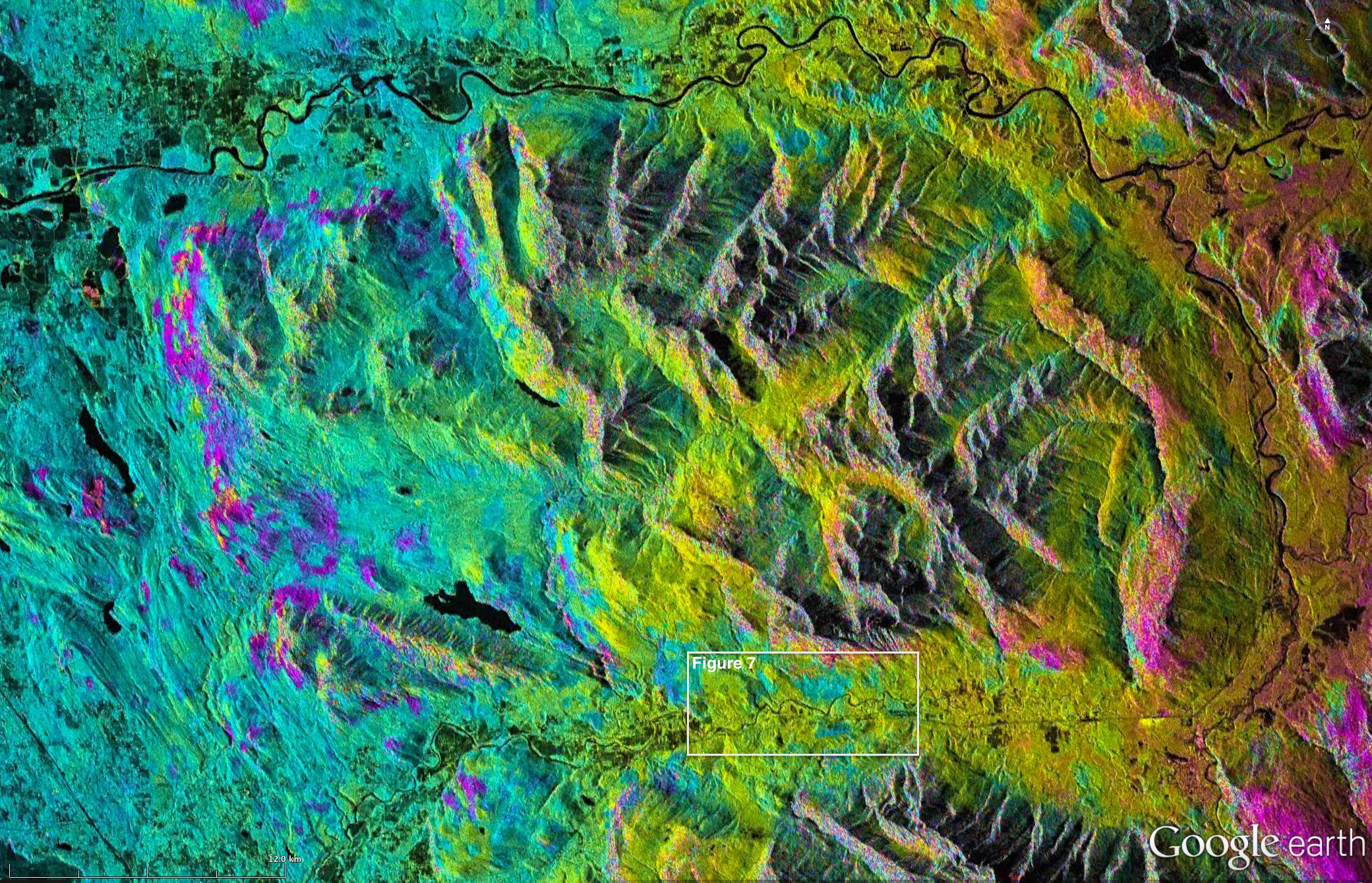
Figure 5, North Fork Stillaguamish River and surrounding area interferogram from ALOS January 28, 2011 and March 15,2011 data

Figure 6, North Fork Stillaguamish River Valley with no deformation signals observed in these data
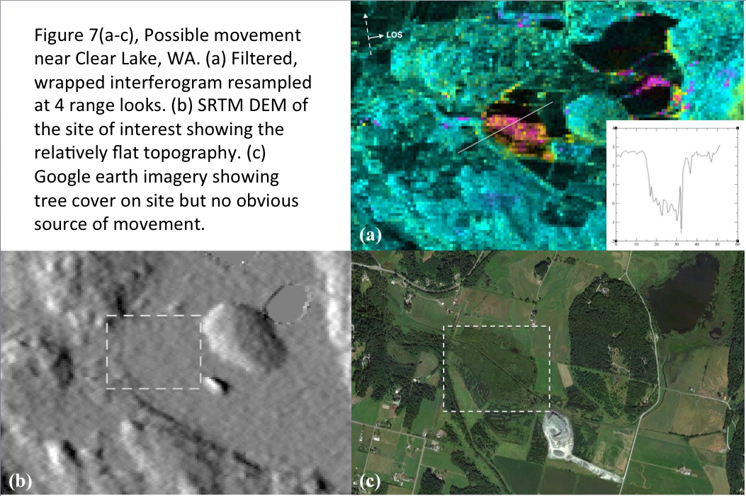
The most distinct signal present in the data is shown in Figure 7a, which shows a localized zone of decrease LOS range. Deformation at this location, representing movement towards the satellite, is unlikely to be associated with landsliding given the local topography (Figure 7b). Additionally, aerial photography of the site (Figure 7c) does not provide a definite source of deformation at this location, though a localized effect of vegetation may be responsible for this phase signal. Possible sources of this measured phase change include an atmospheric artifact, vegetation changes, or a concentration of groundwater causing swelling at the surface.
Decorrelation and the lack of definite ground deformation signals are the combination of several complicating factors. For most interferometry processing, atmospheric effects are the largest source of decorrelation (Zebker et al., 1997), which is of particular concern in this work where all scenes were collected during the wet winter months. Vegetation within the study area is typical of the region, consisting of dense, pervasive, conifer stands, actively managed lots, and rapidly growing Populus (aspen, cottonwood, and poplars) along the riverbanks. By constraining Δt to consecutive SAR scenes to minimize vegetation decorrelation effects, the number of potential interferograms for use in this work were greatly reduced. Even under the best of conditions, using consecutive SAR scenes with small baselines, traditional interferometry does not seem to provide useful data within the heavily vegetated North Fork Stillaguamish River valley for shorter wavelength C-band data.
As noted in previous studies (e.g. Balzter, 2001) C-band data are particularly sensitive to vegetative decorrelation, leading to the use of longer L-band data in several successful landslide studies (e.g. Roering et al., 2009; Jebur et al., 2013). In this work it is demonstrated that for consecutive, short baseline, ALOS scenes, forested slopes ranging upwards of 30° are capable of producing a coherent image. This study was only able to produce one interferogram of ALOS data from four scenes taken within 137 days of each other, which is an insufficient amount of data to draw conclusions but may indicate the fragility of interferometry within the study site. HH-polarization errors in the 12-13-2010 data reduced the possible consecutive interferogram pairs to one, and as shown in Appendix A, longer temporal baselines do not seem to provide high quality data.
Independent of which SAR data is being used in this work there are two major constraints in this work that could all contribute to the lack of detected ground deformation. The first of which are the line of sight angles these SAR scenes were collected at relative to the dominant direction of travel for the imaged slide locations. ERS2 and ENVISAT data was collected on a descending track looking ~285° (WNW) and ALOS data along an ascending track looking ~075° (ENE). Rivers draining the Cascades, such as the North Fork Stillaguamish River run East-West and develop landslides that move roughly North-South. Given the valley and LOS geometry, translational pre-failure movements of landslides in the NFSRV are roughly perpendicular, or blind, to the satellite. It is likely that only vertical ground deformations would be captured along the slides of this study. For example, for ALOS scenes used here (γ=75°, θ=21.5°), a 10cm ground displacement along Skaglund hill (assumed to move due north down a slope of 15°) would produce a line of sight displacement of only 3.3cm. Secondly, this study was developed to determine if pre-failure displacements are occurring along the NFSRV landslides, not to measure known displacements. It is possible that no significant pre-failure displacement was present in reality, leading to no actual displacements for this work to find. Evidence and field testing suggest that large failures, such as Hazel and Skaglund hill, would have some creeping behavior prior to any rapid failure, but these displacements may be too small to detect for these particular landslides.
Conclusions
Developing coherent interferograms in the winter months of western Washington poses several challenges. Dense vegetation, erratic precipitation, and adversely oriented slopes limit the applicability of interferometry for landslide pre-failure deformation detection. Results from this work support previous author’s claims that C-band data is inappropriate for use in heavily vegetated regions due to sensitivity to decorrelation. L-band data from like-polarized consecutive acquisitions were able to produce a coherent interferogram for forested regions within the study area. Ground displacement was not observed at the Skaglund hill site, but the unknown true ground signal and look geometry obfuscate the ability or inability of interferometry to observe these displacements. This work indicates that ALOS data, used either in traditional interferometry or using phase-PS, could be a viable resource for landslide identification and or monitoring, particularly if displacements have a strong vertical component or slides are oriented more favorably with the satellite line of sight.
References
Google Earth Base Imagery, accessed 12.09.14
Balzter, H. (2001). Forest mapping and monitoring with interferometric synthetic aperture radar (InSAR). Progress in Physical Geography, 25(2), 159-177.
Bozzano, F., Cipriani, I., Mazzanti, P., & Prestininzi, A. (2011). Displacement patterns of a landslide affected by human activities: insights from ground-based InSAR monitoring. Natural hazards, 59(3), 1377-1396.
Crosta, G. B., & Agliardi, F. (2003). Failure forecast for large rock slides by surface displacement measurements. Canadian Geotechnical Journal, 40(1), 176-191.
DNR, (2014). http://www.dnr.wa.gov/Publications/ger_list_large_landslides.pdf
DNR, (2013). http://www.dnr.wa.gov/publications/ger_qr_whidbey_island_landslide_2013.pdf
Elsner, M. M., Cuo, L., Voisin, N., Deems, J. S., Hamlet, A. F., Vano, J. A., … & Lettenmaier, D. P. (2010). Implications of 21st century climate change for the hydrology of Washington State. Climatic Change, 102(1-2), 225-260.
Haugerud, R. A., (2014). Preliminary Interpretation of Pre-2014 Landslide Deposits in the Vicinity of Oso, Washington, U.S. Geological Survey Open-File Report 2014-1065, U.S. Geological Survey, Reston, http://dx.doi.org/10.3133/ofr20141065.
Jebur, M. N., Pradhan, B., & Tehrany, M. S. (2013). Using ALOS PALSAR derived high-resolution DInSAR to detect slow-moving landslides in tropical forest: Cameron Highlands, Malaysia. Geomatics, Natural Hazards and Risk, (ahead-of-print), 1-19.
Keaton, J. R., Wartman, J., Anderson, S., Benoît, J., deLaChapelle, J., Gilber, R., and Montgomery, D. R., (2014). The 22 March 2014 Oso Landslide, Snohomish County, Washington. GEER Association Report No. GEER-036, 136p.
Liu, P., Li, Z., Hoey, T., Kincal, C., Zhang, J., Zeng, Q., & Muller, J. P. (2011). Using advanced InSAR time series techniques to monitor landslide movements in Badong of the Three Gorges region, China. International Journal of Applied Earth Observation and Geoinformation, 21, 253-264.
Mazzanti, P., Rocca, A., Bozzano, F., Cossu, R., & Floris, M. (2011). Landslide Forecasting Analysis by Displacement Time Series Derived from Satellite InSAR Data: Preliminary Results. Small,5000, 50-000.
Miller, D. J., (1999), Hazel/Gold Basin Landslides: Geomorphic Review Draft Report, Report to U.S. Army Corps of Engineers, 25 pp.
Petley, D. N., Bulmer, M. H., & Murphy, W. (2002). Patterns of movement in rotational and translational landslides. Geology, 30(8), 719-722.
Roering, J. J., Stimely, L. L., Mackey, B. H., & Schmidt, D. A. (2009). Using DInSAR, airborne LiDAR, and archival air photos to quantify landsliding and sediment transport. Geophysical Research Letters, 36(19).
Rosen, P. A., et al. (2004), Updated repeat orbit interferometry package released, Eos Trans. AGU, 85, doi:10.1029/2004EO050004.
Troost, K. G., & Booth, D. B. (2008). Geology of Seattle and the Seattle area, Washington. Reviews in Engineering Geology, 20, 1-36.
WSDOT, (2013). http://www.wsdot.wa.gov/Projects/SR530/SkaglundHillSlideRepair/
Zebker, H. A., P. A. Rosen, and S. Hensley (1997), Atmospheric effects in interferometric synthetic aperture radar surface deformation and topo- graphic maps, J. Geophys. Res., 102, 7547–7563, doi:10.1029/ 96JB03804.
Appendix A
Back to top