Exogenously constrained dynamic percolation is a stochastic model of fire spread we have developed to simulate fire histories. Each fire begins at a single point in the raster grid, then spreads to its neighbors with some constant probabilitity pspread. This represents the dynamic percolation propoerties of fire spread, an endogenous control that we interpret to represent fine-scale variability in topography and fuels. The fire continues to spread until either: 1) all random tests of spread fail; 2) the fire reaches some randomly drawn fire size (distributed about a mean fire size, μsize); or 3) the fire spans the raster grid. The μsize parameter represents the exogenous constraint on fire spread, interpreted as the duration of conditions conducive to fire spread. Absent the exogenous constraint, the system exhibits a percolation threshold with increasing pspread. This threshold near pspread=0.4951 separates systems with fires that always fail to span the raster grid from those that do span the raster grid.
We have access to an extensive fire history data set for sites of varying topographic complexity (Kellogg et al. 2008) that are located across a N-S and W-E geographic gradient in Washington state. Fire occurrence is indicated by the presence of a scar on a recorder tree, and these scars can be dated to infer the year a site experienced a fire. This data set is unique in that not only the presence of fire scars in a given year was recorded, but also their point locations on the landscape (Everett et al. 2000). This opens possibilities for spatial analysis of the scar patterns previously unheard of in fire history research.
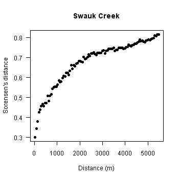
| A metric that we have applied to assess the synchrony of fire history between two trees is the Sorensen's distance (SD). The possible range of values for SD increases from zero (identical fire histories) to one (completely dissimilar fire histories), and we found that the value of SD between a pair of trees on a given site increases as the distance between those trees increases (Kellogg et al. 2008). That is, fire histories are more similar for pairs of trees closer together than pairs of trees further apart. The shape of the curve that describes the relationship between SD and distance (the SD variogram) differs among the sites of varying topographic complexity and we use a model to test whether we can characterize the curves with simple stochastic processes. |
|
In order to simulate the fire histories we require a process of recorder tree scarring. On the raster grid we overlay recorder trees in a point pattern of complete spatial randomness (CSR) and specify a probability that a tree that experiences fire records that fire with a scar (pscar). By spreading multiple fires and recording the fire history for each recorder tree across those fires, we are able to produce a fire history data set that is comparable to that observed for each site. By simulation many combinations of pspread, μsize and pscar we can generate SD variograms of varying shapes that mirror the range of shapes observed across sites. We use Monte Carlo inference procedures to find combinations of pspread, μsize, and pscar unable to be rejected relative to the observed pattern in each fire history site.
We discovered that the sites with the most complex topography had corresponding values of pspread near the percolation threshold, with ill-defined distributions of μsize. In contrast, sites that were less complex topographically had broad distributions of pspread well above the percolation threshold, with narrowly defined distributions of μsize. These results imply that there is a phase transition in the controls of fire spread, where at the dynamic percolation threshold the endogenous and exogenous controls on fire spread are in balance, whereas in less topographically complex landscapes exogenous controls play a stronger role. Replicated spatial patterns of fire spread differ predictably along the topographic gradient. Sites with high topographic complexity are characterized by irregular fire shapes and sites with lower topographic complexity are characterized by more regular (i.e., square) fire shapes. Taken together these results imply that we can use fuel treatments to mimic the strong endogenous controls imparted by topographic complexity in landscapes that exhibit less fine-scale variability in fuels and topography.
We are in the process of evaluating whether an appropriate surrogate for fire size distributions can be calculated for both the observed fire histories and the model outputs. We have indications that the fire size distributions are not similarly distinguished by sites of varying topographic complexity, which implies that bottom-up controls on fire spread do not explain fire size distributions.