- Vectors: Obs
Differences from 5m values Difference from vertical mean
Overlay 5m and 25m velocity - Zonal component: Obs Difference from 5m values Difference from vertical mean
- Meridional component: Obs Difference from 5m values Difference from vertical mean Time series
- u and v at 5m
- Current direction: Differences from 5m values
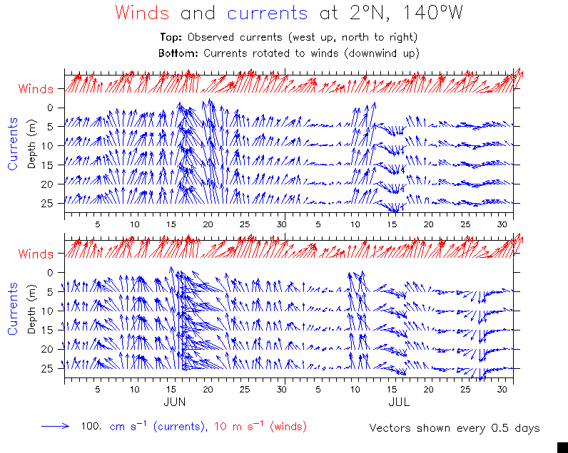
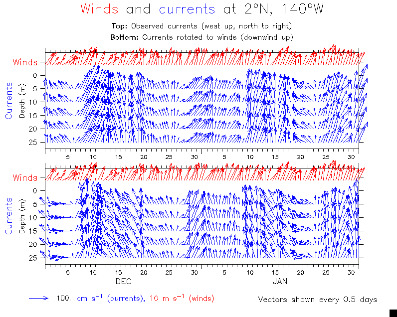
- Wind components
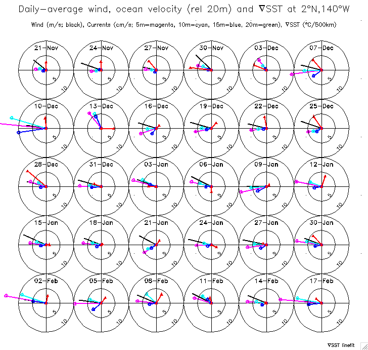
- SST, winds, currents
- Zonal winds and meridional current
- Temperature: Compare TAO Difference from 1m value Difference from vertical mean
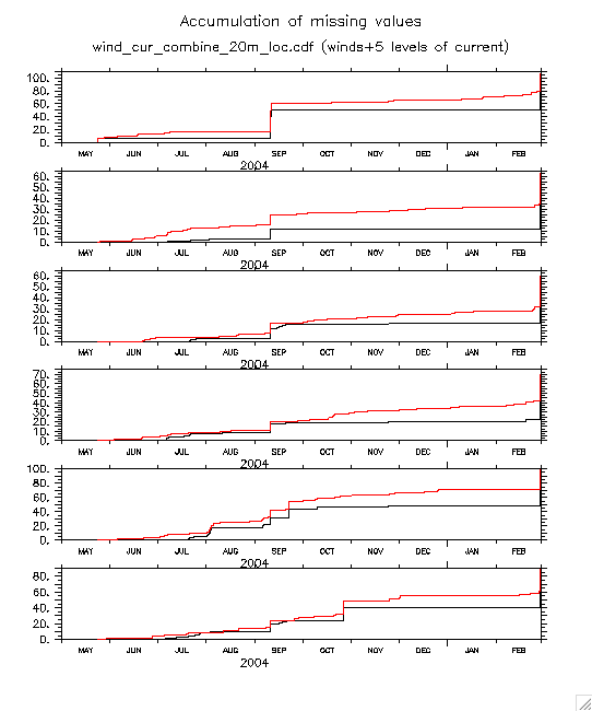
- Checking construction of daily averages: Accumulation of missing values Sep-Oct Sep 10 u interpolation Sep 10 v
- Temperature correction (finally done 15 June 07):
- Time series of correction at each depth
- Mean correction each depth
==>> Plots below are noted "Corrected T°" if made with the new temps. - See section 9 below for the original temperature time series and diagnosis that led to correction.
Subsequent work ....
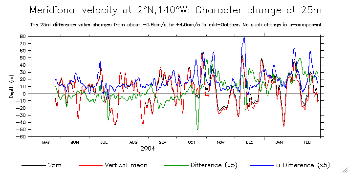
 Note: In interpreting plots showing velocities relative to 25m, keep in mind that v(25m) changed character around 25 Oct 2004. See v difference from vertical mean (Fig.1c) above. The u component did not have a similar change. What does this mean?
- Summary fill plots
- Documenting the short gaps:
- (u,v) (combined)
(u and v have the same gaps, but in some cases the gap may be relevant to resolving the diurnal cycle, so both are of interest) - Met
- Temperature
- (u,v) (combined)
- Total currents: Color-filled T (same but with N up, E right) SST line plot
- Currents relative to 25m: Color-filled T (same but with N up, E right) SST line plot
- Relative to 20m Detail of 1-17 December
- Add geostrophic currents from TMI SST (see TMI section below for description):
ug u-ug 7-day filter
Note that most of these (all the old ones) show shear rel 25m averaged over the whole period. Since we now know that the 25m Sontek crapped out after 7 Oct, these are wrong! See the new ones in 6.b.4 for correct vectors.
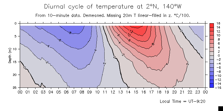
- Temperature: Temperature T difference from 5m Demeaned diurnal T(z)
Checks (examples): 25th day of each month: May-Sep Oct-Feb 3-day chunks: May-Sep Oct-Feb - Velocity
- Time series of diurnal u and v at 5m: Values Anomalies
- Overlay 5m and 25m: Values Anomalies
- Vectors: (These have conventional orientation (N up, E to right) unless noted on plot)
- Reference (vectors and components) Demeaned
- Anomalies
- Vectors relative to 5m
- Vectors relative to 25m
- Vectors rel 25m with overlaid temperature
- Some combinations for choosing among alternatives: West up, north to right North up, east to right
- Winds,temperature and wind/current components
- Find that the 25m CM failed on 7 Oct 2004. Comparisons showing that and consequences:
- Vectors rel 25m before and after Oct failure: 2 plots Overlaid Demeaned
(These are primarily of historical interest to document the failure)
(last 2 of the above plots have wrong labels for wind scale vector: should be 5 m/s) - Resolve above confusion, correct plots are rel 25m to 7 Oct, or rel 20m for the whole period:
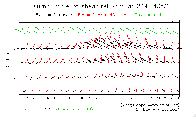
Measured and ageostrophic shear vectors:- Comparisons of 20 vs 25m, and part and whole period:
T and shear rel 20 and 25m (before and after 7 Oct) Overlaid shears different depths and times - Rel 20m, whole period To 7 Oct
- Rel 25m, to 7 Oct Overlay 20 and 25m vectors to 7 Oct
- Comparisons of 20 vs 25m, and part and whole period:
- Vectors rel 25m before and after Oct failure: 2 plots Overlaid Demeaned
- Final (correct) shear plots are rel 25m, to 7 Oct:
T and 25m shear Wind, u, uag vectors
- Met variables Wind and 5m current components overlaid
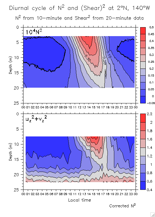
- N-squared and shear-squared Ri
- Line plots
- Diurnal cycle stack plots (Wind, u and uag = Ekman spiral and homogenizing? NO!):
- Night Afternoon
- Movie of hourly velocities (although the mathematical construct of ug and uag in these plots is not useful for the diurnal cycle, because the adjustment to the pressure gradient takes longer than a day, the changes in total u remain relevant, and show the nightly homogenization and consequent reduced shear, and the afternoon restratification, when the velocities become strongly sheared downwind.)
- Histograms of T(1m) - T(25m): Percent Log # of occurrences
- Also see plots from standard TAO in 13b below.
- u,v Shear
- Use only data before 10 Oct 2004: u,v Shear
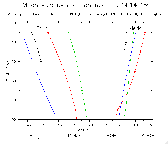
- Mean u and v comparing 2 periods (include table of mean values)
- Also see mean profiles in 15.e.1 below (include u_g)
- T differences among adjacent depths
- Examples (details): Temperature N-squared
- Histograms of N-squared: All depths grouped Overlaid depths
- See section 2f above for the corrections made.
- Whole time series
- Details (2-month chunks): Jun-Jul 2004 Aug-Sep Oct-Nov Dec-Jan 2005 Jan-Feb 2005
- Diurnal cycle rel 25m (meaningless)
- Mean currents:
- Total currents: May-Aug Aug-Nov Nov-Feb
- Currents rel. 25m: May-Aug Aug-Nov Nov-Feb
- Currents rel. 20m: May-Aug Aug-Nov Nov-Feb
- (These were made with Fusion TMI SST)
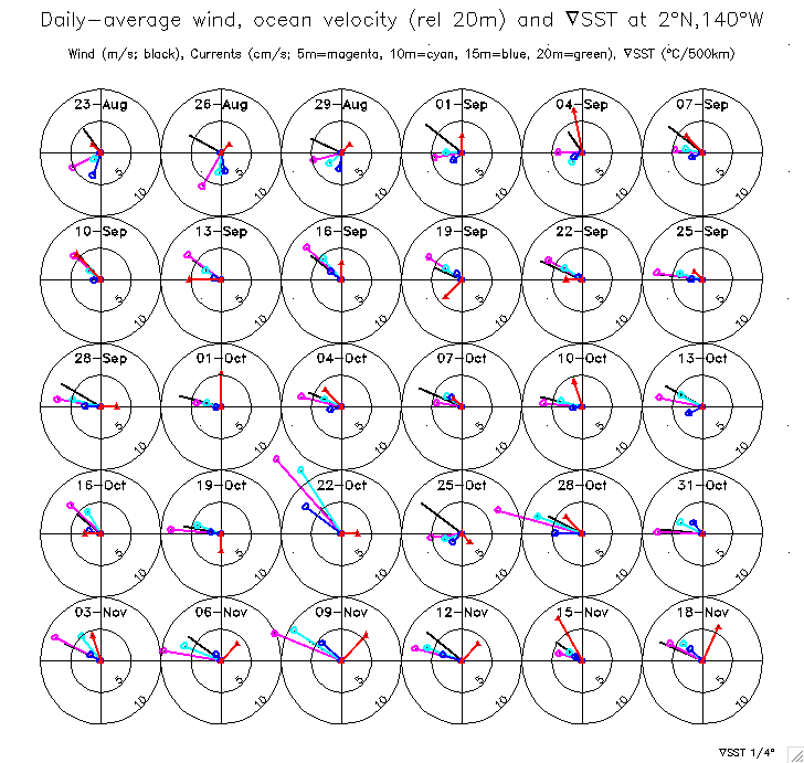
Currents rel. 20m with overlaid SST gradient (1/4° differences): May-Aug Aug-Nov Nov-Feb
Currents rel. 20m with overlaid SST gradient (fitted line): May-Aug Aug-Nov Nov-Feb - Diurnal cycle anomalies
(Includes some u_ag plots incorporating TMI SST gradients)
- Time series of meridional Ekman and total transport (Corrected)
Also compare Ekman at 5°N (Use standard TAO winds) - Check 2°N,140°W winds against climatology:
- ERS total V_Ek
- Schematic Ekman shears
- Checking interannual variability (how typical was this period?):
Zonal wind: 1987-2006 9-month period Dailies vs climatology - Ekman spirals (u_ag): Rel.25m (nice one)
Rel.20m: May-Oct Oct-Feb Whole period
Mean spiral rel 25m when r_s modifies PG flow as well
=> (Also see profiles of u, ug, uag in Figs.15.e.1, and related plots in 15.i and 15.h below) - Ekman and modifed Ekman (Wittenberg) transport time series
- Meridional shear transport time series (Includes v_ag from both ordinary and r_s-rotated u_g)
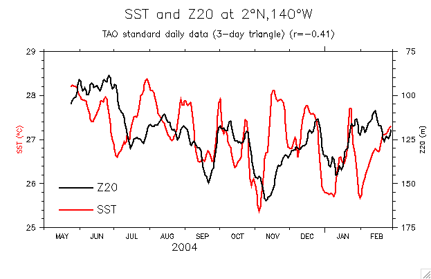
- Z20 and SST
- Near-surface temperatures (ML?):
Time series of T T-SST Detail Depth of SST-0.5,0.2,0.1°C
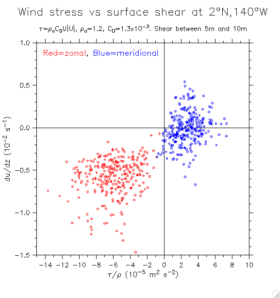
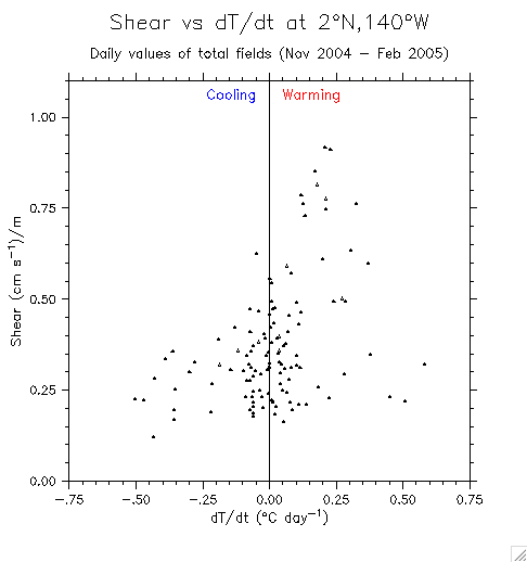
- Scatter plot of stress vs shear Better version
- Windspeed vs ageostrophic shear
- Shear vs stratification Nov-Feb only
- (Also see scatter plots of shear vs wind and SST in 16 below)
==>> This section includes everything that involves u_g due to the SST front!
(A few exceptions include the "Ekman spirals" involving u_ag with the other Ekman stuff in 12 above)
(Lots of confusion about TMI products. The "fusion" product seems to have a significant lag compared to buoy SST. The APDRC 3-day-running mean product is better (still a lag of a little less than a day. Earlier plots here are fusion, plots after about 5 April 2007 are APDRC. Hopefully the labels reflect this! However, for many purposes the lag makes no difference. It really matters only when comparing the phase with buoy values; the statistics and values of the two TMI products are very similar.)
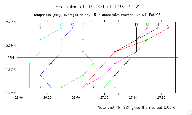
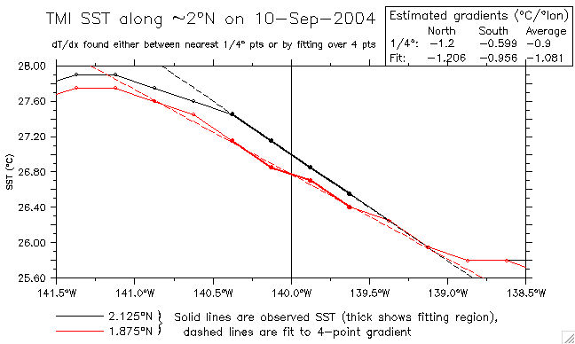
Note that the TMI SST is to nearest 0.05°C: gradient can be funky .... see examples below
- TMI grid structure (on 1/4°, not on integer degrees (interpolation necessary ....):
Over mean SST Over 10 Nov 2004 SST - Examples of SST gradient:
- Meridional: 5-day averages Daily values
- Zonal: 5-day averages Daily values
- 1.4Mb movie of TMI SST near 2°N,140°W
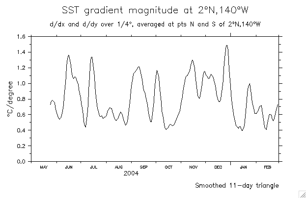
- Compare the gradient found between gridpoints nearest to 2°N,140°W (1/4° differencing) vs a best-fit line:
Examples: 10th day of each month, June 04 through Feb 05:- d(SST)/dx: Jun Jul Aug Sep Oct Nov Dec Jan Feb
- d(SST)/dy: Jun Jul Aug Sep Oct Nov Dec Jan Feb
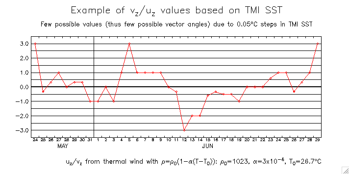
- Example of Ty/Tx (Note that only a few discrete values occur)
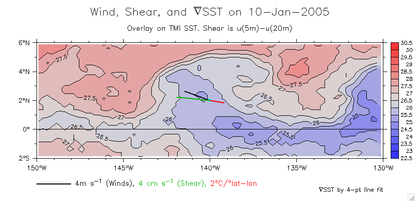
- SST gradient, Shear and Wind overlaid on SST map:
- 1/4° differencing: Jun Jul Aug Sep Oct Nov Dec Jan Feb
- Fitted line: Jun Jul Aug Sep Oct Nov Dec Jan Feb
- Maps at 3-day intervals (corresponding to stackplots in 11e above):
Group: 1 2 3 4 4 5 6 7 8 9 All together on one page
- See stackplots including these gradients (plots 11e above)
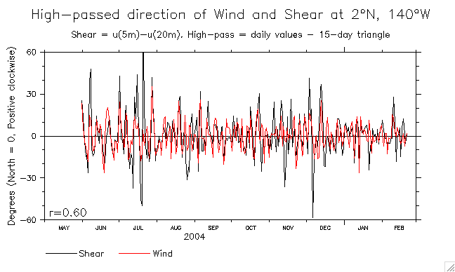
- Directions of wind, shear, and SST gradient
- Directions
- Difference from Shear direction: V1 From smoothed differences
- High-passed differences
- Example of shear, wind SST gradient on 22 Aug
- Compare 1/4° fitting to 2° fitting (APDRC) (Meghan insisted!)
- Use the SST gradient to compute ug. (Linear eqn of state, thermal wind to find ug(z=0) relative to 20m.)
- Mean u,ug,u-ug components:
- Rel. 20m: Whole period (original TMI) Whole period (APDRC SST) May-Oct
- Rel. 25m: May-Oct
- u and v components: Unsmoothed 5-day triangle Overlay SST 5-day filter
- Note the 0.05°C steps mean there are few possible vector angles
- ug overlaid on SST(y,t): Unsmoothed 5-day filter
- ug overlaid on obs currents: ug u-ug 7-day filter
- TMI gradients: Components Magnitude
- Mean u,ug,u-ug components:
- Examples (many examples) showing measured and geostrophic shear, over SST (APDRC)
- Is the shear downwind?
(Comparison between measured shear and geostrophic-adjusted shear vs wind) - Mean shear: u,ug,uag, and wind: Vectors Variance ellipses Over map of SST
Overlay 10, 15, 20m shear 5,10,15,25m rel 5m (til 15 Oct) - Wind, ug, uag shear (When does uag tilt the front?)
- Shear rel 10m Overlay both
- Relative directions of wind/uag/front: Scatter diagram of wind/uag angle difference Time series of angles
- Index of warm-over-cold tilting: time series Compare stratification
- SST advection terms: 7-day RM 31-day RM
7-day RM, 1°-gradient Grad(SST)
- Shear vs wind, a la Santiago and Firing: Direction Magnitude
- Include u-ug: Direction Magnitude Direction (2° SST gradient)
- Shear vs SST Shear vs d(SST)/dt Nov-Feb only
- (Also see scatter plots of shear vs stratification in 14 above.)
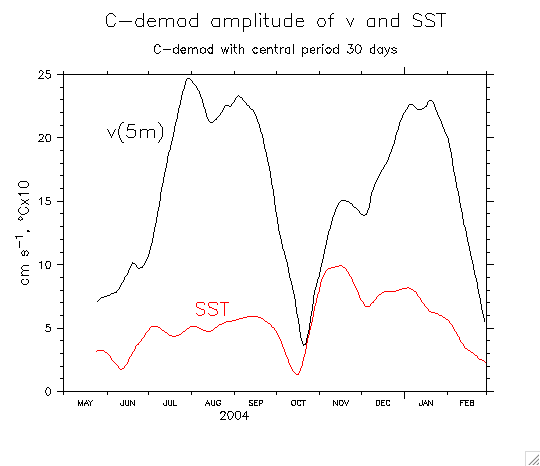
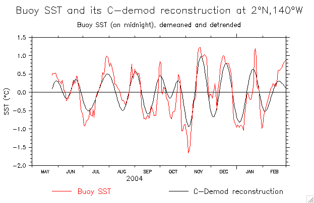
- u,v,T Periods: From 30-day guess 25-day guess
- u,v,T Phase time series: From 30-day guess 25-day guess Winds
- u,v,T Reconstructions: Velocity components Winds
- TMI SST time series and bandpass (Fusion TMI product):
- Along 2°N: SST(x,t) Bandpassed Compare APDRC
- At 2°N,140°W: Obs and bandpass/trend Obs and bandpass+trend
- Mean amp/phase of 30-day signal). Along 140°W: Amp Phase Along 2°N: Amp Phase
- Zonal section (x,t) along 2°N: Amp Phase
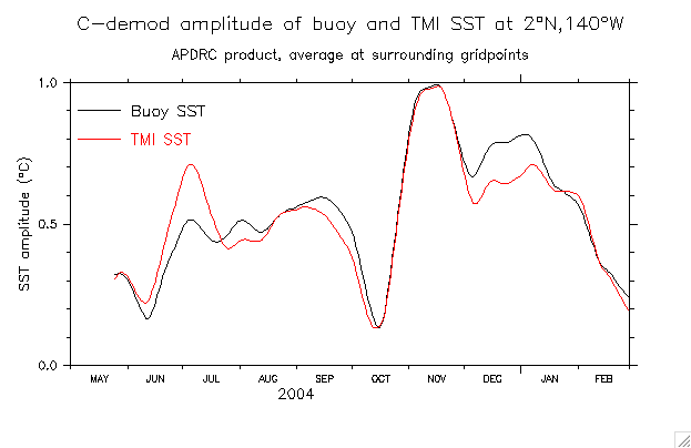
- Buoy SST: Obs and bandpass Bandpass+trend Bandpass and C-demod amplitude
- Winds/currents overlays and comparisons in various combinations:
- Zonal winds/current (obs and bandpass): current wind overlay wind/current bandpass
- Meridional winds/current (obs and bandpass): current wind overlay wind/current bandpass
- Overlay zonal and meridional amplitude/bandpass: current wind
- Overlay SST and current amplitude/bandpass (Fusion TMI product):
- u/SST: C-demod amplitude bandpass
- v/SST: C-demod amplitude bandpass
- Shear and geostrophic combos (Fusion): Amplitudes Overlaid time series
- Documenting APDRC TMI vs buoy SST (and some comparisons to Fusion TMI):
- Time series: Whole record Over a short interval: Fusion vs APDRC Kelly/Dickinson correction Example of K/D method
- Blanks in APDRC record
- Differences between APDRC and original (Fusion) TMI:
- (y,t) timeseries at 140°W: Fusion APDRC Difference
- Time series at 2°N,140°W: Data and difference Lag correlation
- Along 2°N (x,t): Fusion APDRC
- Comparisons between buoy and TMI (APDRC) SST:
- Time series overlay
- Complex demodulation:
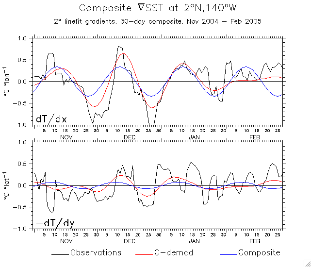
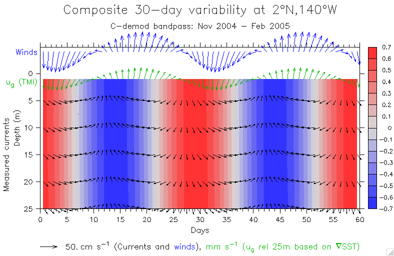
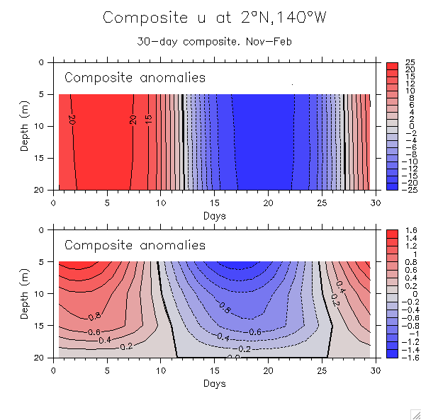
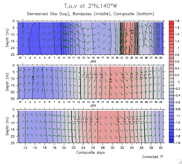
- First look at a composite (30 days)
- (Initial) Checks (overlay bandpass and composite over Nov 04-Jan 05):
u[k=1]=wind u[k=2]=ug u[k=3]=5m v[k=1]=wind v[k=2]=vg v[k=3]=5m Buoy SST TMI SST TMI SST (unshifted) - Composite over Nov-Feb:
- C-demod quantities:
Amplitude Phase Period (All periods overlaid) Reconstructions - Composite over reconstruction and data:
- T,u,v vectors Winds and Grad(SST) (1/4°) Grad(SST) (2° linefit) Windspeed and QE
- Phase agreement between winds and Grad(SST)? (Not! Wind signal is small. Grad(SST) phase varies so average phase is meaningless) (Redo with 2° fitting)
- Composite combinations (T,wind,shear,ug,ua):
- Anomalies (Anomalies over color T) Include mean vectors
- Lineplots: 5m 10m
- (OLD, IGNORE: (1/4° fitting) Composite combination: All Shear rel 20m u and u-ug)
- Phase advancement and cosine angle: Buoy SST APDRC SST gradient (2°) (u,v)
- Test using the cdmod phase to "unstretch" the bandpass
- Composite stratification:
- T and T-T(25m) Overlay vectors Add uag vectors Add mean shear vectors
- Bandpass time series T-T(1m)
- Corresponding velocity and shear: u v
- Qe, dT/dt and windspeed composites
- C-demod quantities:
- (Initial) Checks (overlay bandpass and composite over Nov 04-Jan 05):
- Some comparisons between d(SST)/dt and Grad(SST): d(SST)/dt magnitude Grad(SST) components
- Tauy and dvdt: Bandpass Composite
- Binned composites:
- T and u binned on SST
- 3-panel timeseries: Obs, Cdmod, Composites (both kinds)
- Validations (Obs, Cdmod, Composite): T,u,v u_g,v_g
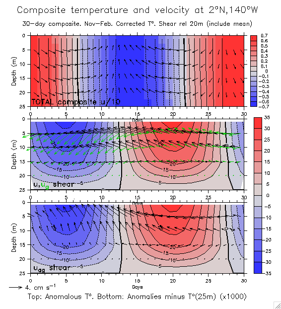
- (z,t) sections: Compare old vs new composite u,v,T Show u,u_g,u_ag shear Add mean velocity
- Ertel PV
- Time series: Total Q 3 components of Q
- Validate Ertel Q terms (obs, cdmod, composite) (1-D)
- Original composite on 3 depths (not useful?): Obs, cdmod, composite 30-day composites overlaid
Mean profiles: Full record Pre-7 Oct
(Note in the above means that the 22.5m value only includes pre-7 Oct in both cases).
- T and u binned on SST
- Observed shear and stratification during a TIW transition
- Obs, bandpass and composite T,u,v: Nov Dec Jan Feb
TAO u,v timeseries at 0°,140°35m: 2002-2006 1990-2006
- vg from TAO DH at 125°W to 155°W (missing most of our period)
- vg from BMRC:
- Time mean along 2°N
- vg(z,t) 150°W-130°W zonal average: May 2004 to Feb 2005 1995-2007
- vg(x,t) along 2°N

![u[k=1]=wind](check_composite_u_keq1.gif)
![u[k=2]=ug](check_composite_u_keq2.gif)
![u[k=3]=5m](check_composite_u_keq3.gif)
![v[k=1]=wind](check_composite_v_keq1.gif)
![v[k=2]=vg](check_composite_v_keq2.gif)
![v[k=3]=5m](check_composite_v_keq3.gif)