Figures from a lecture given at the Virginia Air and Space Museum
Figures from a lecture given at the Virginia Air and Space Museum
Hampton, VA, Feb 18, 1998
>>> Page still under construction. Browse if you want, but some important things are still missing ...
These are most of the figures (and a few extras) shown in this lecture.
In some cases I show the figure as I used it, in others there are links to the original source. This is done in cases where the figures are updated regularly by the source agency.
The figures are approximately in the order shown in the lecture.
Also see much more discussion of the mechanisms and processes of El Niño on my FAQ page.
Introductory figures:
Understanding the average conditions in the tropical Pacific:
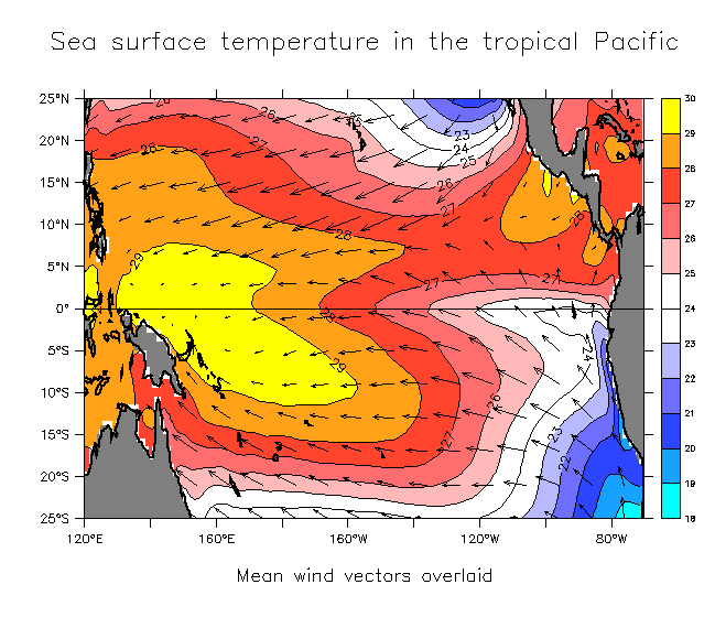
- Mean SST and winds in the tropical Pacific.
- Things to notice:
- Although in general the SST gets warmer closer to the equator, in the east the cool water is found on the equator. This is known as the east Pacific cold tongue.
There is a roughly 5-6°C (9-10°F) temperature contrast from east to west on the equator.
The winds blow from the cooler to the warmer water. In particular, winds converge on the west Pacific warm pool.
Where there is warm water in the tropics, air is heated from beneath and rises. Air from surrounding regions is drawn in to fill the gap.
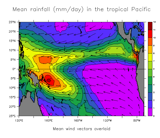
- Mean rainfall and winds in the tropical Pacific.
Note that the rainfall occurs over the warm water where the winds converge. As warm, humid air rises, heavy rain occurs. Amounts range up to about 12 mm (1/2 inch)/12 hours, averaged over the entire year. That is almost 9 meters (29 feet) of rain a year! This gives an idea of the strength of the rising motion over the warm pool.
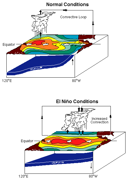
- Schematic diagram showing ocean-atmosphere coupling during non El Niño conditions:
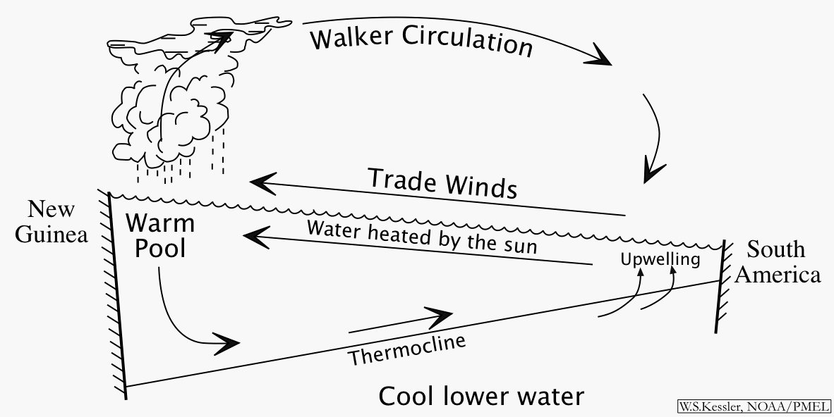
The ocean and atmosphere are a coupled system. They do not work in isolation, and the interaction and feedbacks between them are crucial.
In this system, we can start a description at any point in the cycle. For example, we observe that there is cool water in the east and warm in the west (see the above figure "Mean SST and winds in the tropical Pacific"). The winds blow towards the warm water, since that heats the atmosphere and makes the air rise, then other air flows in to fill the gap. (These are the trade winds, that the Spanish used to sail from their colonies in South America to the Philippines). I have drawn the sea surface (wiggly line) tilted up to the west for a reason. Because of the pressure of the trades, sea level at Indonesia is about 1/2 meter higher than at Peru. At the same time the trade winds act on the ocean as well. The westward winds along the equator push the warm water (heated by the sun) off to the west, drawing up the thermocline and exposing the cooler water underneath in the east. This upwelling cools the eastern surface water, and we have returned to the starting place of the description.
So if you ask me "Why are there trade winds?", I will say "That's simple, there are trade winds because there's warm water in the west". But if you ask me "Why is the water cold in the east and warm in the west?", I'll say "That's simple too, it's because there are trade winds". The ocean and the atmosphere are inextricably coupled together.
The thermocline is the boundary between the cold deep water (that extends to the bottom of the ocean and around the world) and the warmer upper layer. In the tropics it forms a relatively sharp boundary. The trade winds, in piling up warm water in the west, make a thick warm layer in the west that pushes the thermocline down there, while it rises in the east. The shallow eastern thermocline allows the winds to pull up water from below, water that is generally much richer in nutrients than the surface layer. (This is so because life lives mostly in the sunlit zone. Available nutrients there are quickly taken up by some form of life (plankton). Debris from the living creatures rains down into the lower layer, where nutrients dissolve, making the deep water rich, so that wherever there is upwelling, there is abundant life.)
Note that the rising air over the western Pacific is associated with rainfall (see the figure of rainfall and winds just above). When air rises it cools, and can hold less evaporated water. The water comes out as rain. But in returning to a liquid state, it releases the heat that was used to evaporate it from the ocean surface (heat that came from the sun), and this middle atmosphere heating amplifies the rising motion. This is a principal mechanism for heat from the sun to warm the atmosphere (the atmosphere by itself is relatively transparent to solar radiation).
What happens to cause El Niño?
- Schematic diagram showing ocean-atmosphere coupling during the onset of El Niño:
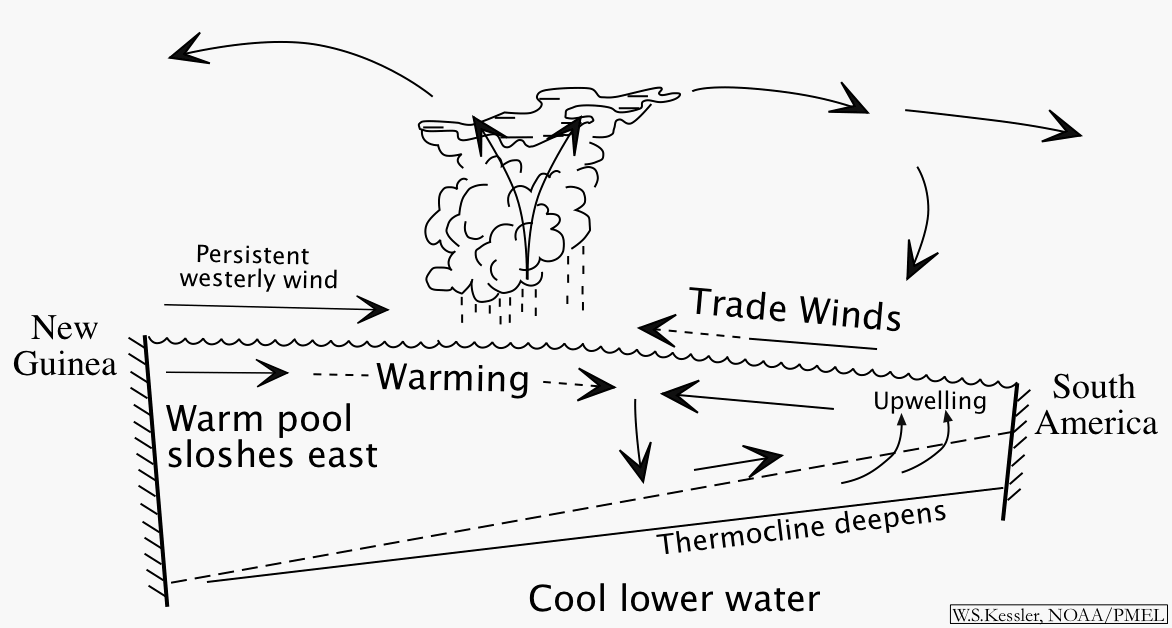
We don't know what initiates El Niño. But we do see that it apparently does not take much to destabilize the strong-trade-wind/large-temperature-contrast non-El Niño state discusses in the section above. This is because of ocean-atmosphere coupling.
Suppose a relatively brief opposing wind occurs over the west Pacific warm pool. It may last for as little as one month. This starts an eastward current that pushes the warm pool a little bit east of it's usual position. If the ocean and atmosphere were not coupled, then this motion would soon stop when it ran into the trade winds. But we know (see above diagram) that the trade winds exist because of the temperature contrast between east and west. If the central Pacific is warmed from the west, even a small amount, then the rising motion will tend to move east with the warm water. That means the trade winds will shrink back east a little. But then the pressure of the trades holding up the sea surface slope to the west is weakened, and even more west Pacific water tries to slosh eastward. That warms the central Pacific a little bit more, and the rising air moves further east, and the trades shrink more. This collapse continues until the water is warm across the Pacific, the trades are weak, and the thermocline and sea surface slope flatten out. That is El Niño.
While we can describe the collapse pretty well, we don't seem to know what makes the system ready to collapse, or what exactly causes the opposing winds in the first place.
There are two main theories at present. The first is that
the event is initiated by the reflection from the western boundary
of the Pacific of an oceanic Rossby wave (type of low-frequency
planetary wave that moves only west). The reflected wave is supposed
to lower the
thermocline in the west-central Pacific and thereby warm the SST
by reducing the efficiency of upwelling to cool the surface. Then
that makes winds blow towards the (slightly) warmer water and really
start the event. The nice part about this theory is that the Rossby
waves can be observed for months before the reflection, which implies that El Niño is predictable.
The other idea is that the trigger is essentially random. The
tropical convection (organized largescale thunderstorm activity)
tends to occur in bursts that last for about a month, and these bursts
propagate out of the Indian Ocean (known as the Madden-Julian
Oscillation). Since the storms are geostrophic (rotating according
to the turning of the earth, which means they rotate clockwise in the
southern hemisphere and counter-clockwise in the north), storm winds on
the equator always blow towards the east. If the storms
are strong enough, or last long enough, then those eastward winds
may be enought to start the sloshing. But specific Madden-Julian
Oscillation events are not predictable, and so to the extent that this is
the main element, then El Niño will not be predictable.
In my opinion both these two processes can be important in different
El Niños. Some models that did not have the MJO storms were successful
in predicting the events of 1986-87 and 1991-92. That suggests that
the Rossby wave part was a main influence at that time. But those
same models have failed to predict the events since then, and the
westerlies have appeared to come from nowhere.
- Another schematic diagram comparing mean and El Niño conditions.
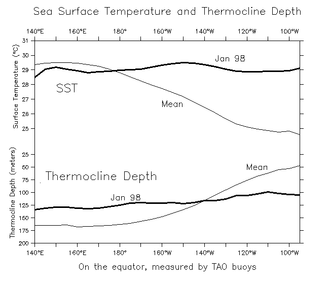
- Equatorial SST and thermocline depth during mean and El Niño conditions..
Compared to the mean gradients of thermocline depth and SST (light lines), during January 1988 both were nearly flat (heavy lines).
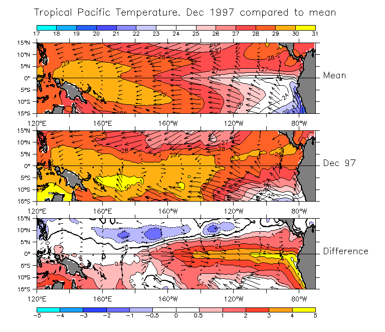
- Comparing SST and winds in mean vs El Niño conditions.
- Things to note:
- During the onset of El Niño, the warm pool sloshes east.
The usual east-west temperature contrast on the equator nearly vanishes.
Since the trade winds are partly driven by this temperature contrast, when there is no SST gradient the equatorial trade winds diminish greatly.
When the east is warm, the anomalous winds blow towards the anomalously warm water (bottom panel).
- Salinity along 155°W during November 1997
The extremely low salinity is an indication of the very heavy rainfall as the warm pool moves east. Compare salinity along the same section one year previously, when salinity at the equator was more than 1 PSU higher. (Also see other CTD sections from buoy cruises.)
Note that 0°, 155°W is
deg;W is not in the region that usually gets heavy rain (see Fig "Mean rainfall and winds" above).
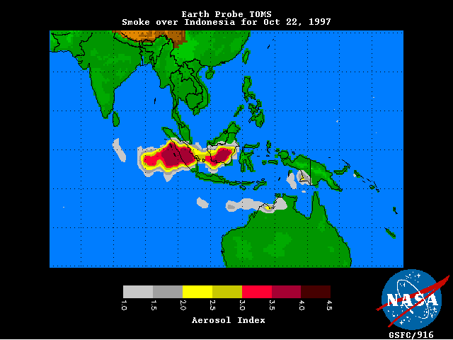
- On the west side of the Pacific, the eastward shift of the warm pool/rainfall region has left Indonesia suffering a severe drought. When plantation owners burn the forest to make room for crops (often oil palms for export), the absence of the usual monsoon rains this year led to massive forest fires that have spread smoke over the entire region.
When does El Niño occur?
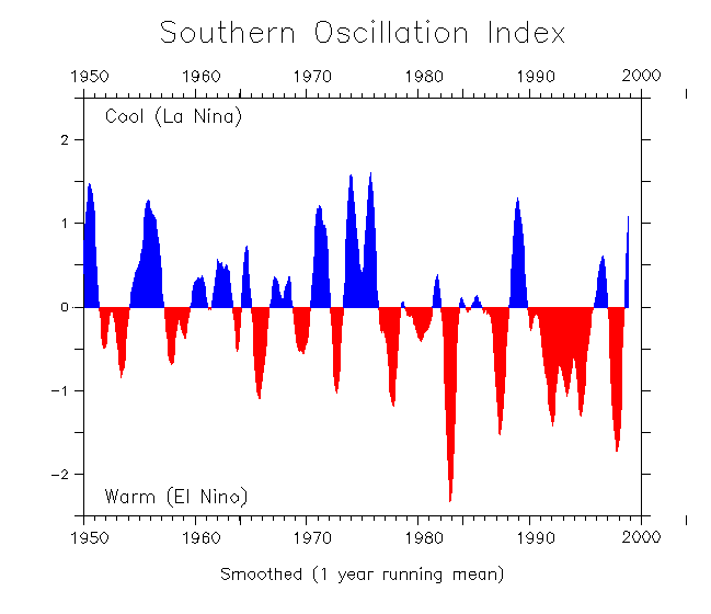
- Time series of the Southern Oscillation Index from 1950-99
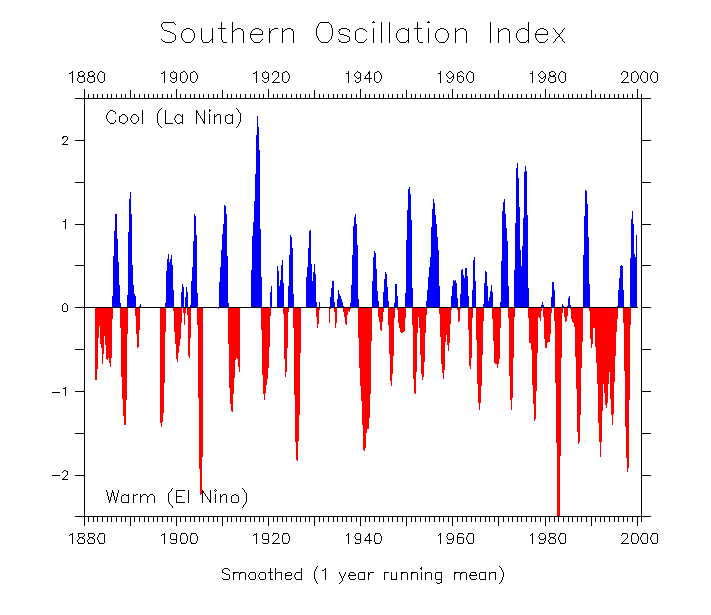
- SOI time series extending back to 1882
Read a discussion of the SOI on my FAQ page. (Then use your back button to return here).
Note that the SOI is defined as the normalized anomaly of surface atmospheric pressure between Tahiti and Darwin Australia. When the pressure difference is large (positive anomaly) then high pressure in the east drives the usual trade winds; when it is small (negative anomaly) the winds reverse. So negative values of the SOI indicate El Niño. But for the purpose of the museum talk I reversed the sign and plotted up for warm events.
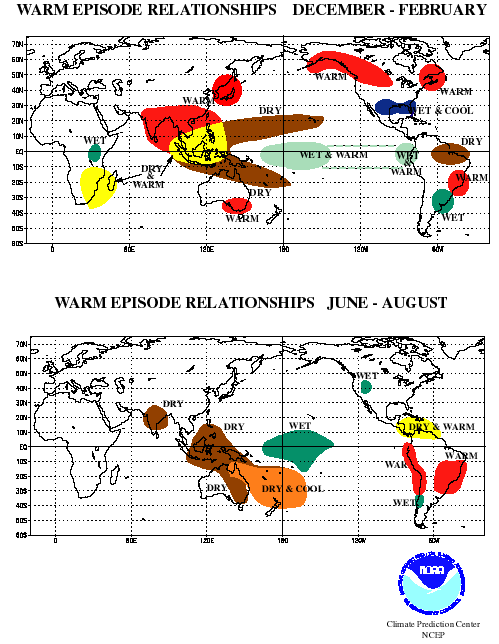
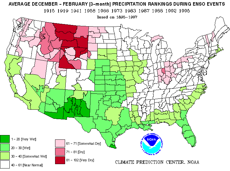
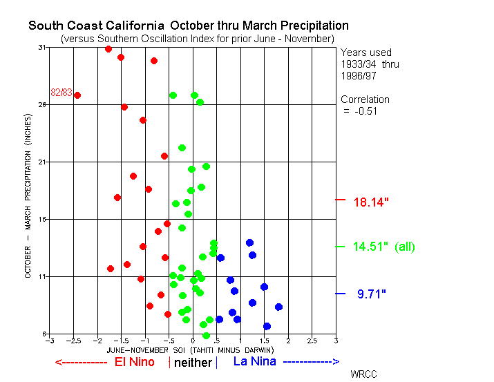
What are the remote effects of El Niño?
Some statistical relationships compiled by averaging over observed El Niños:
What is the mechanism by which El Niño affects U.S. weather?
- Schematic jetstream position figure coming to this space soon!
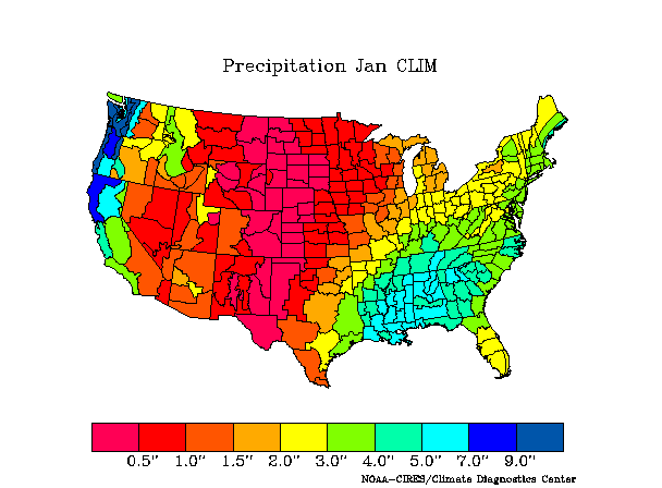
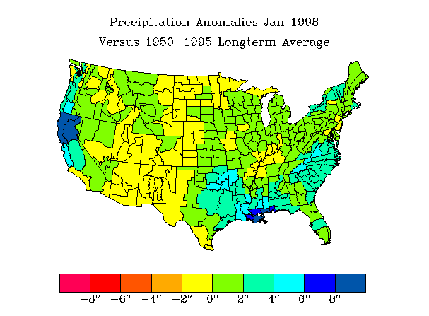
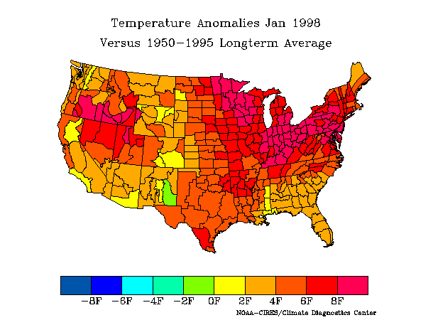
What has happened so far this year?
Compare the effects on the continental US temperature and precipitation during the winters of 1982-83 and 1997-98 (two strong El Niños).
Time series showing rainfall accumulation this winter in various locations.
These figures are updated daily by NOAA's Climate Prediction Center.
->->-> Note. As of July 2001, many of these links are out of date. Most of this stuff is still available under the web page of NOAA's Climate Prediction Center, but you have to look for it.
This brings home the point that close to the main action, in the tropical Pacific, the effects of El Niño are much stronger than in remote regions. If you're Peruvian, you don't need a TV weatherman to tell you that it's El Niño. But in the U.S., El Niño is only one of many influences on our climate. That's why we see such a large variance in the weather during El Niño winters.
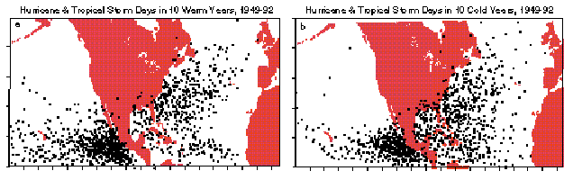
It is also worth noting that El Niño does not only have negative effects on our weather. During a typical summer, 5-6 hurricanes make landfall on our shores. El Niño changes the upper level winds so as to cause a large vertical contrast in the winds over the western tropical Atlantic. This tends to shear hurricanes (which extend high into the atmosphere) apart. During 1997, not a single Atlantic hurricane reached the U.S.
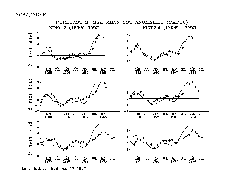
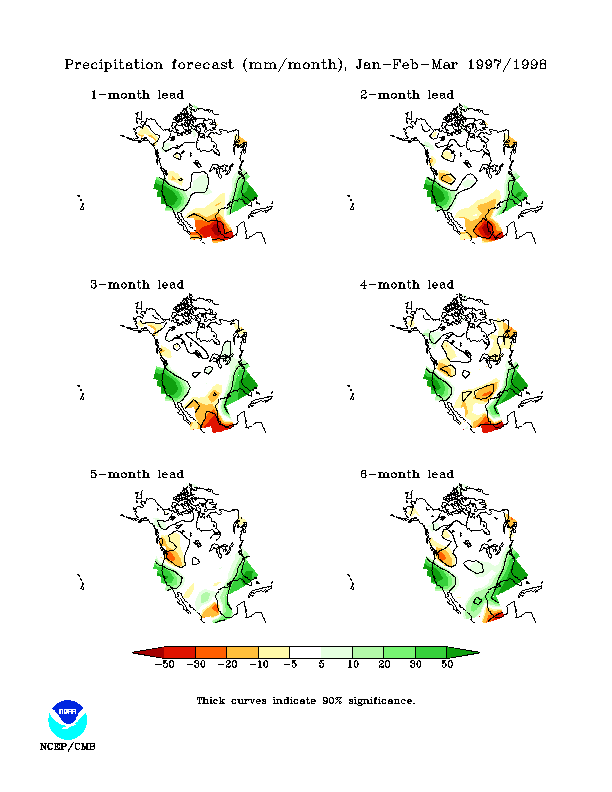
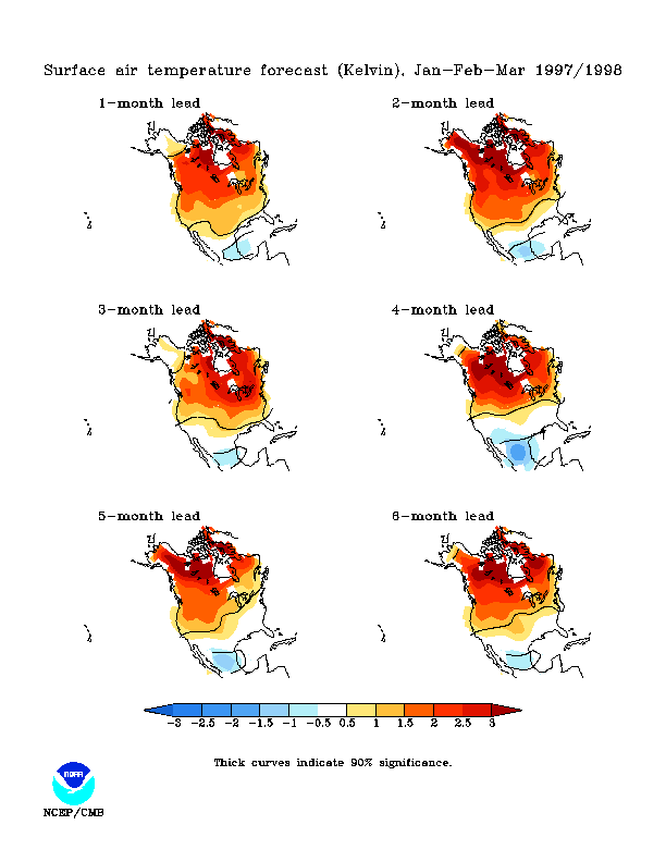
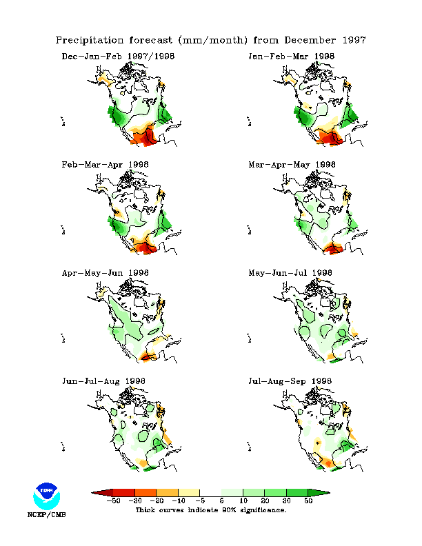
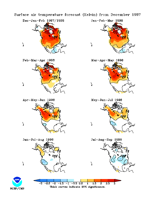
Forecasting El Niño and its effects on North America
Forecasts of future conditions made in December 1997:
Here's some links for current forecasts:
From the NOAA Climate Modeling Branch (my favorite):
->->-> Note. As of July 2001, many of these links are out of date. Most of this stuff is still available under the web page of NOAA's Climate Modeling Branch, but you have to look for it.
Does El Niño cause particular storms? It's a hard question.
Much more in-depth discussion of the mechanisms and processes of El Niño is given on my FAQ page.
Stuff below here is work in progress, notes, junk ....
! compare tropical Pacific SST in LN/normal/EN conditions
en-ln-normal-sst.gif
! timeseries
kaimi-155w-salinity.gif
! other seagoing Kaimi links
atlasrt/kaimi.html
! tao home page www.pmel.noaa.gov/toga-tao/home.html
realtime.html
pmel-graphics/gif/atlas.gif
buoy.html
! also want particular storm impact page