Billy Kessler
Oceanographer
Pacific Marine Environmental Laboratory / NOAA
Seattle
"Your tax dollars at work"
![]()
Billy Kessler
Oceanographer
Pacific Marine Environmental Laboratory / NOAA
Seattle
"Your tax dollars at work"
1. What is El Niño and how does it relate to the usual situation in the tropical Pacific?
2. Where did the name El Niño come from? When was it discovered?
3. Has there been any research to cause a small man-made El Niño?
....If it were possible to change the temperature of the water, would it reverse an El Niño?
4. An idea for a science fair project.
5. Some words of caution on El Niño forecasts.
6. Does El Niño cause specific storms (Florida tornadoes of February)?
7. Why don't you see much publicity about the causes of El Niño?
8. Does El Niño originate solely in the tropics, or do the midlatitudes play an important role?
9. Do volcanoes or sea-floor venting cause El Niño?
9b. What is a fluid "instability"?
10. Does Mother Nature have a purpose for El Niño?
11. Will El Niño affect the tides and ferocity of the water in Drake Passage?
12. What are El Niño teleconnections?
13. What are the differences between statistical and dynamical forecast models of El Niño?
14. How can I understand the conflicting El Niño forecasts I find on the web for this coming winter (1997-98) in California?
15. How do models used to predict El Niño work? How accurate are they?
16. Why can't I find any information about links between El Niño and global warming?
17. Is there a scale for the intensity of El Niño?
18. Why do diagrams of El Niño show a pointy wedge of warm water pointed west from South America?
19. Why do El Niño and La Niña only occur in the Pacific?
20. Why is the ocean salty?
21. What have been the major new developments for in situ monitoring of SSTs?
22. Does El Niño create dangerous conditions for marine life, and will it have a lasting effect on marine animals?
23. Is El Niño a theory or a proven fact?
24. Is the periodicity of El Niño events (every 2-7 years) the same as La Niñas?
25. How come the sea surface temperature of Savannah, GA and San Diego are different ... since they lie at the same latitude?
26. Is El Niño caused by pollution or global warming?
27. Why is the annual increase in atmospheric CO2 concentrations smaller during El Niño years than La Niña years?
28. What initiates El Niños?
29. What effect would a well-placed tsunami have on El Niño?
30. Frustrating student question.
31. Most absurd El Niño theory yet.
El Niño is an intermittent disruption of the climate system centered in the equatorial Pacific that has effects on short-term climate around the Pacific basin.
To understand El Niño, it is necessary to understand the normal trade-wind system in the tropical Pacific. (Click the thumbnail for a schematic diagram of this system 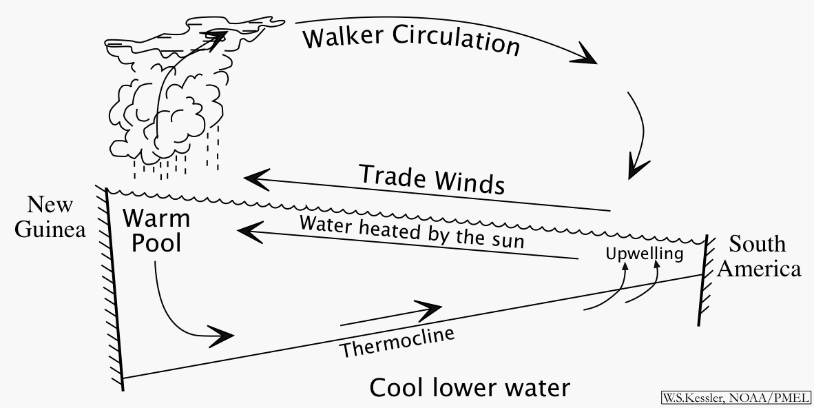 ). The sun heats the equatorial regions more strongly than the rest of the globe, so air tends to rise from the surface there, replaced by inflow from the subtropics. The Coriolis effect turns these inflows to the right in the northern hemisphere and to the left in the southern, resulting in the great trade-wind belts that blow equatorward and westward over the width of the the tropical Pacific.
This sets up the coupled ocean-atmosphere interaction in the tropical Pacific in which the winds determine the water temperature but the water temperature also determines the winds, in a chicken and egg situation.
In this system, we can start a description at any point in the cycle. For example, we observe that there is cool water in the east and warm in the west (see the figure "Mean SST and winds in the tropical Pacific"). The winds blow towards the warm water, since that heats the atmosphere and makes the air rise, then other air flows in to fill the gap. (These are the trade winds, that the Spanish used to sail from their colonies in South America to the Philippines). Because of the force of the trades, sea level at Indonesia is about 1/2 meter higher than at Peru. At the same time the trade winds act on the ocean as well. The westward winds along the equator push the warm water (heated by the sun) off to the west, drawing up the thermocline and exposing the cooler water underneath in the east. This upwelling cools the eastern surface water, and we have returned to the starting place of the description.
). The sun heats the equatorial regions more strongly than the rest of the globe, so air tends to rise from the surface there, replaced by inflow from the subtropics. The Coriolis effect turns these inflows to the right in the northern hemisphere and to the left in the southern, resulting in the great trade-wind belts that blow equatorward and westward over the width of the the tropical Pacific.
This sets up the coupled ocean-atmosphere interaction in the tropical Pacific in which the winds determine the water temperature but the water temperature also determines the winds, in a chicken and egg situation.
In this system, we can start a description at any point in the cycle. For example, we observe that there is cool water in the east and warm in the west (see the figure "Mean SST and winds in the tropical Pacific"). The winds blow towards the warm water, since that heats the atmosphere and makes the air rise, then other air flows in to fill the gap. (These are the trade winds, that the Spanish used to sail from their colonies in South America to the Philippines). Because of the force of the trades, sea level at Indonesia is about 1/2 meter higher than at Peru. At the same time the trade winds act on the ocean as well. The westward winds along the equator push the warm water (heated by the sun) off to the west, drawing up the thermocline and exposing the cooler water underneath in the east. This upwelling cools the eastern surface water, and we have returned to the starting place of the description.
So if you ask me "Why are there trade winds?", I will say "That's simple, there are trade winds because the water is cold in the east and warm in the west". But if you ask me "Why is the water cold in the east and warm in the west?", I'll say "That's simple too, it's because there are trade winds". The ocean and the atmosphere are inextricably coupled together.
The thermocline is the boundary between the cold deep water (that extends to the bottom of the ocean and around the world) and the warmer upper layer. In the tropics it forms a relatively sharp boundary. The trade winds, in piling up warm water in the west, make a thick (150 meter) warm layer in the west that pushes the thermocline down there, while it rises in the east. The shallow (30 meter deep) eastern thermocline allows the winds to pull up water from below, water that is generally much richer in nutrients than the surface layer. (This is so because life lives mostly in the sunlit zone. Available nutrients there are quickly taken up by some form of life (plankton). Debris from the living creatures rains down into the lower layer, where nutrients dissolve, making the deep water rich, so that wherever there is upwelling, there is abundant life.)
Note that the rising air over the western Pacific is associated with rainfall (see the figure of rainfall and winds just above). When air rises it cools, and can hold less evaporated water. The water comes out as rain. But in returning to a liquid state, it releases the heat that was used to evaporate it from the ocean surface (heat that came from the sun), and this middle atmosphere heating amplifies the rising motion. This is a principal mechanism for heat from the sun to warm the atmosphere (the atmosphere by itself is relatively transparent to solar radiation).
Because the warm pool pumps great amounts of heat and moisture into the upper atmosphere, this system is one of the major driving forces of world climate. The huge source of heat helps set the path of the jet streams (storm tracks) that control temperate-zone weather, much as a large rock in a stream determines the pattern of water flow, including wavey motions that extend well downstream of the rock. Therefore, when the warm pool changes shape or position, the effects ripple outward to affect much of the world's weather.
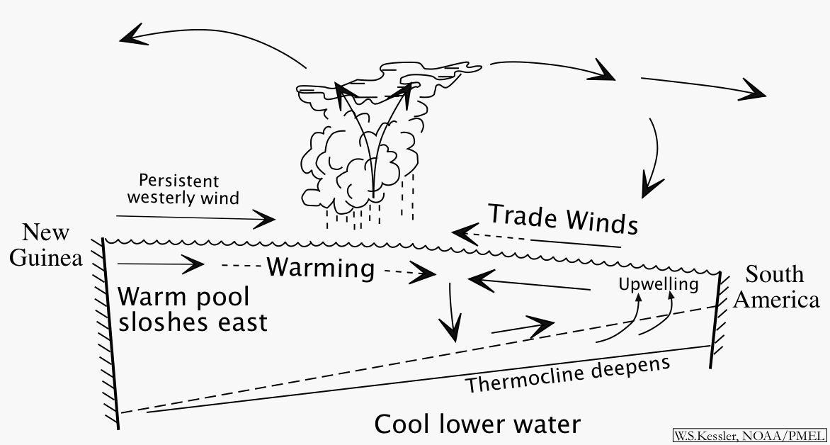
During El Niño events, this entire system relaxes. The trade winds weaken, particularly west of the Dateline, and the piled-up water in the west sloshes back east, carrying the warm pool with it. The region of rising air moves east with the warm pool, and so does the pumping of heat and moisture into the upper atmosphere, distorting the usual paths of the jet streams, which eventually causes the changes in weather around the world. With weakened trade winds, the upwelling in the east correspondingly weakens; as the warm pool moves east the upwelled water is also not as cool as during normal periods. When eastern SST becomes warm the east-to-west temperature contrast is small, and so the trade winds weaken even further, leading to a complete collapse with essentially flat conditions across the entire equatorial Pacific.
We don't know what initiates El Niño. But we do see that it apparently does not take much to destabilize the strong-trade-wind/large-temperature-contrast non-El Niño state discusses in the section above. This is because of ocean-atmosphere coupling.
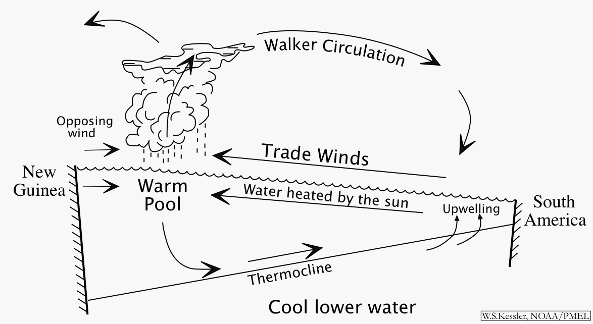
Suppose a relatively brief opposing wind occurs over the west Pacific warm pool. It may last for as little as one month. This starts an eastward current that pushes the warm pool a little bit east of it's usual position. (See schematic diagram at right). If the ocean and atmosphere were not coupled, then this motion would soon stop when it ran into the trade winds. But we have shown that the trade winds exist because of the temperature contrast between east and west. If the central Pacific is warmed by flow from the west, even a small amount, then the region of rising air will tend to move east with the warm water. That means the trade winds will also shrink back east a little, since those winds are caused by the rising air. But then the pressure of the trades holding up the sea surface slope to the west is weakened, and even more west Pacific water tries to slosh eastward. That warms the central Pacific a little bit more, and the rising air moves further east, and the trades shrink more. This collapse continues until the water is warm across the Pacific, the trades are weak, and the thermocline and sea surface slope flatten out. That is El Niño (See schematic diagram at right). Note that this collapse extracts its energy from the background state of the Pacific (the fact that sea level is higher in the west), which is a signature of instability (see question 9b below).
 While we can describe the collapse pretty well, we don't seem to know what makes the system ready to collapse, or what exactly causes the opposing winds in the first place.
There are two main theories at present. The first is that the event is initiated by the reflection from the western boundary of the Pacific of an oceanic Rossby wave (type of low-frequency planetary wave that moves only west). The reflected wave is supposed to lower the thermocline in the west-central Pacific and thereby warm the SST by reducing the efficiency of upwelling to cool the surface. Then that makes winds blow towards the (slightly) warmer water and really start the event. The nice part about this theory is that the Rossby waves can be observed for months before the reflection, which implies that El Niño is predictable.
The other idea is that the trigger is essentially random. The tropical convection (organized largescale thunderstorm activity) in the rising air tends to occur in bursts that last for about a month, and these bursts propagate out of the Indian Ocean (known as the Madden-Julian Oscillation). Since the storms are geostrophic (rotating according to the turning of the earth, which means they rotate clockwise in the southern hemisphere and counter-clockwise in the north), storm winds on the equator always blow towards the east. If the storms are strong enough, or last long enough, then those eastward winds may be enought to start the sloshing. But specific Madden-Julian Oscillation events are not predictable much in advance (just as specific weather events are not predictable in advance), and so to the extent that this is the main element, then El Niño will not be predictable.
In my opinion both these two processes can be important in different El Niños. Some models that did not have the MJO storms were successful in predicting the events of 1986-87 and 1991-92. That suggests that the Rossby wave part was a main influence at that time. But those same models have failed to predict the events since then, and the westerlies have appeared to come from nowhere. It is also quite possible that these two general sets of ideas are incomplete, and that there are other causes entirely. The fact that we have very intermittent skill at predicting the major turns of the ENSO cycle (as opposed to the very good forecasts that can be made once an event has begun) suggests that there remain important elements that are await explanation.
The most severe effects of El Niño are found close to the equator. The usual pattern of deserts in Peru and heavy rainfall over Indonesia and the west Pacific reverses. Forest and range fires can occur in Indonesia (as has been happening in recent months, exacerbated by deliberate burning) and Australia, while Peru suffers flooding, with accompanying epidemics of cholera and other sewage-borne diseases. The food chain in the rich upwelling region is disrupted, so fish die off, with consequent hardship for the birds, mammals and people that survive on that stock. The warmer water near Central America spawns more and stronger hurricanes, which can go as far west as Hawaii. The entire sequence of the event lasts about one year, and events are usually separated by 2-7 years, in an irregular and not-well-understood pattern (see a time series of occurrences of El Niño since 1950, and since 1882).
Effects of El Niño and La Niña on North America are shown in a schematic diagram with text explanation from NOAA's Climate Prediction Center.
Back to top
The name El Niño (referring to the Christ child) was originally given by Peruvian fisherman to a warm current that appeared each year around Christmas. What we now call El Niño seemed to them like a stronger event of the same type, and the usage of the term changed to refer only to the irregular strong events. It wasn't until the 1960s that it was widely realized that this was not just a local Peruvian occurrence, but was associated with changes over the entire tropical Pacific and beyond.
The following quote is given in the introduction to an excellent (scholarly) book by George Philander of Princeton University ("El Niño, La Niña
and the Southern Oscillation", Academic Press, 1990). These
are remarks quoted from Senor Federico Alfonso Pezet's address
to the Sixth International Geographical Congress in London
in 1895.
The Paita sailors, who frequently navigate along the coast in small craft, either to the north or the south of that port, name this countercurrent the current of "El Niño" (the child Jesus) because it has been observed to appear immediately after Christmas.
As this countercurrent has been noticed on different occasions, and its appearance along the Peruvian coast has been concurrent with rains in latitudes where it seldom if ever rains to any great extent, I wish, on the present occasion, to call the attention of the distinguished geographers here assembled to this phenomenon, which exercises, undoubtedly, a very great influence on the climatic conditions of that part of the world.
The Southern Oscillation was named by Sir Gilbert Walker in 1923, noting that "when pressure is high in the Pacific Ocean it tends to be low in the Indian Ocean from Africa to Australia". This was the first recognition that changes across the tropical Pacific and beyond were not isolated phenomena but were connected as part of a larger oscillation. Walker was Director of Observatories in India and was mostly concerned with variations in the Indian monsoon.
The first real description of El Niño/Southern Oscillation in
terms of physical mechanisms was by Prof Jacob Bjerknes of the
Univ of California, Los Angeles in 1969.
Back to top
Asked by a college student (and in various forms by people around the world).
To answer this question we need to consider how much heat change is involved in climate oscillations such as El Niño.
The increase in SST during January through July 1997, averaged over the equatorial Pacific (10S-10N, 150E-75W) was about 1.62°C.
But the quantity we need is heat content, which proportional to the mass of water times its temperature. This can be estimated from the TAO buoy array, by multiplying the density of water (1030 kg/m3) times the heat capacity of seawater (4000 J/kg/K) times the area of the TAO array times the vertical integral of buoy temperature with depth. (see the note on units and symbols below) (The area was estimated by dividing the array into regions each assumed to be represented by one buoy. Each day, the above calculation was made summing over the area of only those buoys with data for that day). Performing this calculation with TAO temperatures, the time series of heat content in the upper 500m shows that this quantity increased by about 3.5e22 J ("3.5 times ten to the twenty-second Joules") during July 1996 through March 1997, then decreased slightly. (See also other related calculations).
Now we can compare that heating to human engineering power. One of the most powerful devices humans have created is the H-bomb. The heating during El Niño can be related to the power of the H-bomb as follows. One kiloton of TNT is about 4.18e12 J. Therefore. 3.5e22 J is about equivalent to 8e9 kilotons, or about 400,000 20-Mt bombs. That assumes the power of those bombs could be directed entirely to heating (i.e. not to moving) the water.
Another way to look at this is to estimate the heating that would be done by a bomb if all the energy went into heating. Consider a 1-Mt H-bomb, releasing 4.18e15 J of energy. That energy would heat a volume of about 1 cubic kilometer of seawater 1°C. That certainly seems like a lot of energy, but the volume of just the upper water of the equatorial Pacific (10°S-10°N, upper 200m) is about 6 million cubic kilometers. Compared to H-bombs, climate changes are a different order of beast entirely.
Another way to look at it is in terms of power plants. Increasing the heat content by 3.5e22 J over the period July 1996 to March 1997 is a heating rate of about 1.5e15 W (1.5 PW). A large power plant can generate about 1000 MW, so the El Niño-related heating is equivalent to the total output of roughly 1,500,000 power plants working continuously for 8 months.
Of course, this argument is misleading in that El Niño probably does not actually heat that much water. What it does is redistribute the heat already in the ocean, first moving it in to the TAO array region, then out. However, it probably is the case that the work required to move that much water is similar in magnitude to the work required to do the heating as above. This calculation is harder to do because we can't measure the currents nearly as well as the temperatures.
Other ideas to avert El Niño might be conceived. In principle, one could imagine some mechanism that would lower the temperature of the surface water by mixing with deeper water. Obviously, any kind of stirring would take work, a lot of it. What about dissolving a huge amount of salt in the surface water, increasing its density without changing the temperature, and thereby causing it to sink, and cooler water to rise? A rough calculation shows that raising the salinity by about 2 parts per thousand would make water at 28°C denser than water at 23°C, and thus cause it to sink significantly (and consequently cooler water would rise). To do this to a 50 meter high column of water 1 meter square (50 tons) would take about 100 kg of salt. For a smallish area of the equatorial Pacific (say 1000 km square) would take about 10 to the 11th tons of salt. Let's say a pile 1 km square and 100 km high. I guess not!
Even if we could make the kind of deliberate changes of ocean temperature suggested above, it is not at all clear that this would be desirable. It is useful to remember that El Niño is a normal part of the climate system of the Pacific, as much as, say, winter is a feature of continents. While it might seem convenient to make winter go away, in practice much vegetation and animal life has evolved to require either the rain or cold of winter and would be severely disrupted if these changed. (Not to mention the difficulty of keeping children in school through endless summer!). Similarly, El Niño serves the function of draining excess warm water from the equatorial Pacific, and preventing this function would reverberate through the rest of the system in unpredictable ways. Some of those we might not like, and we are not in a position to predict what those would be. The ecology of the Pacific has adapted to El Niño fluctations, so even though there can be devastating effects in certain areas, in the long run El Niño is part of the ecosystem; not to be messed with lightly. One example of this is that it is hypothesized that the unusual eastward winds and currents associated with El Niño have allowed some species of plants, fish and birds to colonize the islands of the central Pacific, whereas if there were only the westward trades winds this could not have happened. I have even read that it may have been only because of these anomalous El Niño winds that the Polynesians were able to reach as far east as the islands around Tahiti. During the normal trade wind regime the westward winds would have made such voyages much more difficult. Also, in El Niño conditions Polynesians could undertake exploratory voyages to the east with the knowledge that the winds would change in a few months, guaranteeing them a ride home.
In any case, even if we had a way to channel these effects into direct heating of ocean water, it is clear from the magnitudes involved that people are nowhere near the ability to modify the climate on this scale.
There is one exception. By burning fossil fuels at the rate we do, we increase the CO2 concentration in the atmosphere in a way that could well cause climate changes (global warming), as most scientists think is now happening. The difference is that this change represents the "efforts" of all the industrial world acting over a century to just get the change under way.
A note on units used here:
kg = kilogram.
m = meter.
K = degrees Kelvin (same units as °C, but starting from absolute zero or -273.15°C)
J = Joule. This is a unit to measure work or energy.
W = Watt. 1 W = 1 J/second. This is the power (rate of doing work).
Abbreviations for large numbers: M = meta (10e6 or 1 million). P = peta (10e15 or 1 million billion).
Back to top
Requested by a parent.
Here's an idea. This experiment is similar to what actual scientists are doing right now.
The project is to construct some forecast models of El Niño's development over the next few months. We don't know what it will do. Will it get more intense?, weaken?, remain strong?, and if so for how long? These are the subject of much debate in the scientific community right now, and many efforts are under way to predict and understand it.
The models would be forecasts made using several assumptions, and the main result would be graphs showing how the forecasts compared with actual evolving conditions.
One model would be called "persistence". That is, whatever conditions are occurring now, they will continue. Surprisingly, persistence is often a hard-to-beat forecast, and weather forecasters score themselves on how much better than persistence thay can do. A second model is continuation of the trend. That is, if the sea surface temperature (SST) is warming up it will continue to warm at the same rate. Obviously that can't go on forever but in many ways a trend is a good indicator of future trends. A third model is random changes. Get a random number generator (or pick numbers out of a hat). Each day or week, use the random numbers to predict what the change of SST will be (scale the numbers to keep it reasonable). Those are three simple models that can be used to project forward from current conditions. Essentially that's what weather forecast models do, just more sophisticatedly (see question 13). Maybe you can think of some other ways to make forecasts (if you get something that works, send it in!)
Choose a few buoys from our network in different regions of the tropical Pacific (for example, on the equator, off the equator, in the east, and the west). Get the data from our web page (click for detailed instructions to get this data). Make and graph predictions for each buoy chosen for a month or two ahead, then collect observations as they come in (the data files are updated daily). Graph the observations against the three predictions. My guess is that each model would be successful in some regions for some periods of time. Other extensions would be to compare forecasts beginning at different times. Perhaps a forecast begun with September comditions is good for 3 months, but one begun in December is only good for one month. Etc.
Another simple project is to determine how significant an effect El Niño has on your local region. Do this by gathering an assortment of local weather time series from your region (monthly rainfall, temperature, etc) (available at the web pages of the National Weather service). Then get an index of El Niño like the Southern Oscillation Index (see Question 17 for a description and graphic, and download the values at NOAA's Climate Prediction Center. The specific data links are: values for 1951-today and 1882-1950. Note that the SOI monthly values are very jumpy and must be smoothed by a 5-month running mean). Compare the turns of the El Niño/La Niña cycle with changes in your local weather; this could either be through a listing of El Niño/La Niña years and good/bad local weather, or by correlation of the two time series (send me e-mail for how to do correlation). You will probably find out that some aspects of your local weather are related to the El Niño/La Niña cycle and some are not. Also that some strong El Niño or La Niña years make a difference but some do not. This reflects the fact that, far from the center of action in the tropical Pacific, El Niño is only one of many influences on weather.
If your are pretty good at math and computer programming (at least 8th-grade math), then I have a more advanced project that you can find here.
There are many other sites for classroom lessons on El Niño on the web, including:
"The Long Paddock", Queensland (Australia)
The Univ of Illinois
PBS (Nova)
NOAA Climate Diagnostics Center
NOAA El Niño theme page
Back to top
Written for a middle school class in San Diego at the request of their teacher.
It is important to remember that El Niño is not the only effect on weather. It is but one fluctuation among many, and the weather we experience is the sum of all of these overlaid and interacting. Most of these interactions are poorly understood, particularly the longer-term ones, and as we get longer and longer records we become aware of more and more complexity. The different El Niños occur on different background states, at different times of year, and therefore have different total effects. Therefore, one cannot simply speak of the isolated effects of El Niño on weather in San Diego. There is only the ever-changing combination of influences. That is the main reason why we cannot produce reliable long-term forecasts.
Scientists study El Niño partly for its own effects, but also partly
as an example of how this kind of climate oscillation interacts with
the rest of the climate system. We know there are many such oscillations,
and we would like to be able to fit the whole picture together. We
hope that what we learn about the climate system from studying El Niño
will help us understand other, less obvious, variability.
Back to top
Asked all the time by many people
El Niño is not "responsible" for any particular storm. But El Niño is a vital element all the same. For example, winter is not responsible for any particular snowstorm; but winter is certainly a crucial part of why the northern hemisphere has snow in January.
There are two ways in which El Niño adds punch to the storms over North America. First, it draws the jet streams further south in the eastern Pacific. That means more storms in general across the southern tier of the U.S. Second, El Niño adds punch to the storms because the stronger and eastward-displaced warm pool (see question 1) pumps additional moisture into the upper atmosphere, where it is blown towards North America and caught up in the more-southerly jet streams.
So while it is impossible to prove that El Niño caused the particular tornadoes that struck central Florida in late February, just as it is impossible to say that winter caused a particular snowstorm, it is the likely suspect. Perhaps there would have been strong tornadoes on this day in Florida without El Niño, but it appears not.
We cannot run experiments to see what a parallel earth without an El Niño this year would do. But a group at NOAA's Climate Diagnostic Center in Boulder, CO, is trying something similar using numerical forecast models. First, they run the model with the actual conditions (that is, including this year's (1997) El Niño-induced SST anomalies in the Pacific) and produce weather forecasts, just like the regular ones. Then they make another run, in which everything is the same as the first one except that they change the Pacific SST to be like a "normal" year. The difference between these forecasts gives an indication of the effect of El Niño conditions in the Pacific on the specific weather events being forecast. The results for forecasts of Florida precipitation during the tornadoes of Feb 23 suggest that El Niño did indeed add punch to these storms. Visit the web site of this forecast group.
Back to top
Asked by a research analyst at the Univ of North Carolina.
The reason that you don't see much publicity about the causes of El Niño is that we don't understand the origins of the event. We do, however, have a pretty good understanding of how it evolves once it has begun, and that gives a useful ability to make forecasts 6-9 months ahead for some regions. That is the information you see because that is the present state of reasonably-secure knowledge. Of course, there are a variety of theories, and many scientists are working on various aspects of the genesis, which would presumably extend the predictive skill out another few months or even years.
The fact is, at several points over the past two decades we thought we had working theories of what causes El Niño. Unfortunately (or perhaps fortunately for those who like scientific challenges), nature has shown that those theories were at best incomplete. For example, during the mid-1980s a group at Columbia University developed a fairly simple theory and wrote a computer model to produce predictions based on it. This was successful in predicting the 1986-87 and 91-92 events almost a year in advance, and they were (figuratively?) breaking out the champagne. Then along came the event of 1993, then another in 94-95, and most prominently the present event, none of which developed according to the ideas in their theory.
The main reason this is so difficult is that the processes that cause El Niños involve the full complexity of ocean-atmosphere interaction on a global scale. We have developed a reasonably good understanding of how the atmosphere works (at least in theory), once the sea surface temperature (SST) that drives the atmospheric circulation is known. (We are somewhat further behind when it comes to the ocean, which is much harder to observe). That works pretty well to run the atmospheric models to make short-term weather forecasts, because the ocean changes rather slowly. But, when you consider longer-term phenomena like El Niño, it is not enough to specify the SST; one must consider how the ocean will evolve under the winds, and then how the altered ocean will modify the winds, and so on, in many tricky and sensitive feedback loops. We are just beginning to be able to see how these fundamentally coupled disturbances work, and generally only in very idealized cases. Remember that for a long time meteorologists only talked to meteorologists, and oceanographers only to oceanographers. Now we are really at the initial stages of being able to think about these coupled problems.
Nevertheless, it seems to me that we are able to a lot of good for society
even at our present stage of ignorance, since even without knowing what
drives El Niño, we can recognize it, and then know (largely from statistics
of past events) what the effects will be on regions far removed from the
tropical Pacific. That's what the publicity is about, and that is appropriate,
although perhaps not so satisfying to those such as yourself who ask "why?".
Back to top
Asked by a State Park naturalist in Oregon
We observe that large-amplitude climate signals occur well outside the tropics during El Niño events. The question is, are those precursors of El Niño, or are they far-field effects essentially incidental to the equatorial Pacific "main event"? Both points of view have their advocates.
On the one hand, there is no doubt that the entire ocean-atmosphere system is interconnected, and each El Niño event occurs on the background of existing conditions, which includes the positions of the mid-latitude jet streams as an important component. In addition, newly-developing theories of the slow (decadal) evolution of the equatorial circulation point to a key role for water masses that originated in the subtropics or higher latitudes. These water masses are part of a global-scale meridional overturning circulation, in which water sinks at high latitudes (due to evaporation or winter cooling making it more dense), and travel a circuitous subsurface route to the equator, where they upwell. Then the water flows poleward at the surface back to the subtropical gyres, warming under the sun to complete the cycle, which probably takes several decades or so. Now researchers have shown that the sinking water masses can have different temperature and salinity properties, and that as these reach the equator, they modify the conditions prevailing there, and it is thought that these slow changes may be the reason why some periods have many El Niños (like the 1990s) while others don't.
On the other hand, numerical models of the equatorial ocean-atmosphere system (including both fairly simple to quite complex formulations) commonly develop interannual climate oscillations similar to El Niño. This indicates that at least the basic phenomena is intrinsic to the general situation of a wide ocean spanning the equator, and theory bears this out. Therefore I think the prevailing sentiment among climate researchers is that the mid-latitude influences referred to above can modify individual El Niños, but that fundamentally it is an instability of the equatorial ocean-atmosphere system (see question 9b below) that would occur in recognizable form regardless of what happens poleward of say 15-20 degrees latitude.
However, at present we do not know with any certainty how El Niño
events are initiated. Therefore the tropical/extra-tropical debate cannot
be said to be resolved. Another regional influence that is cited by some
is the Asian monsoon. As with the mid-latitude situation, the fact that
El Niño develops in models without an Indian Ocean again indicates
that the Pacific ocean/atmosphere system is probably sufficient, but we
really don't know for sure. These topics are the subject of much current
research.
Back to top
Asked by a New Englander.
The idea that volcanoes cause El Niño events originally gained prominence because of the eruption of Mt Chichon in Mexico in Feb 1982 (preceding the El Niño of 1982-83), and the eruption of Mt Pinatubo in the Philippines) in June 1991 (preceding the El Niño of 1991-92). However, when the time series of El Niños is compared to the time series of volcanic eruptions it becomes clear that the relationship is coincidental. There are numerous large volcanic eruptions around the world and almost as many El Niños. In that situation there is almost always an eruption at some time preceding any El Niño. Scientists are now convinced that this relation is coincidental.
Certain experiments bear this out. For example, several computer models predicted the onset of the 1991-92 event as early as January 1991, based on the state of the ocean-atmosphere system at that time, well before Pinatubo. That indicates that the ocean-atmosphere system was already generating the El Niño, and Pinatubo occurred coincidentally. Computer models integrating the equations of fluid motion and the flow of heat routinely produce El Niño-like variability completely on their own. Of course, computer models are not reality, but these experiments suggest that El Niño is a natural mode of variability of the ocean-atmosphere system, as much as, for example, a thunderstorm. While we do not have a complete picture of how the El Niño cycle operates, these models (and a developing theoretical understanding) suggest that the fluid envelope of the earth is prone to developing various kinds of instabilities, ranging from storm systems lasting a few hours or days, to El Niño, to longer-term fluctuations that we are just beginning to explore (see question 9b below). There is no reason to think that external processes such as volcanoes are a necessary element.
None of this is to say that volcanoes don't affect the climate. They most certainly do, and since El Niños occur against the background existing climate, there is little doubt that volcanic eruptions that eject large amounts of dust into the stratosphere must modify the frequency, character and strength of El Niño events, possibly in important ways. The distinction I make is between "slowly modify the background" and "cause" El Niño.
As far as deep-ocean vents modifying the ocean temperatures, researchers now think that this source of heat does contribute to the long-term evolution of the ocean state. The chemical signatures of undersea vents are of great interest as tracers of the slow deep circulation of the ocean, and therefore these signatures are studied carefully. (The deep circulation is so slow that its currents cannot be measured directly, so we look at tongues of chemical tracers to estimate the speed, direction and transport of the flows). Numerous scientific papers discuss these questions, studying a variety of chemical constituents. What is consistently found is that the traces spread extremely slowly through the water column and are vastly diluted. There is little doubt that over very long periods the effects of undersea venting on the ocean are large, both for their heat and for their contribution to the chemical makeup of the ocean. However, these effects occur on timescales of thousands of years, and certainly do not produce the kind of rapid signals that characterize El Niño. To trigger an El Niño event, one would look for a signal that produced surface variability on a month to month or year to year timescale, and undersea venting has never been observed to do that.
It is indeed tempting to look for nice clean causes of complex oscillations
like the El Niño cycle. Unfortunately (or perhaps fortunately for those of
us who like scientific challenges), it seems that the ocean-atmosphere
system is well-capable of generating these oscillations on its own, and
the task now is to understand how this happens. Volcanoes and sea-floor
venting are part of the slowly-changing background state on which phenomena
like El Niño occur, and add to the complexity of the task.
Back to top
9b. What are instabilities?
(Part of a later answer expanding on the question of volcanoes and El Niño.)
Fundamentally, El Niño is an instability, which means it is a fluctuation that gains energy from the background state. It also implies a strong element of unpredictability. Instabilities are almost by definition hard to pin down, but some examples may be helpful. When two adjacent flows of water move at different speeds (for example in a small river where the center flow is faster than near the sides or where rocks disrupt the smooth flow, or where two rivers join, or where two ocean currents flow in opposite directions), then we see eddies forming and spinning. Why do such eddies grow? Why don't the two flows simply slide by each other smoothly? The answer is that when the contrasting flows are fast enough, friction at a molecular level prevents the water from sliding smoothly. So the boundary between them breaks down into tiny spinning blobs. Once the tiny blobs form, they have their own friction with the surrounding water, including the other tiny blobs, and tend to join and absorb others, growing into larger blobs. Picturing a fast creek with rocks, we see a series of spinning eddies some of which can grow fairly large, apparently from nothing, gaining their energy from the initial flow of the river. This means that the eddies slow the overall flow, so they can be seen as a kind of fluid friction. Much of the effort in computer modeling of fluid flows involves representing this friction; since it often occurs on smaller scales than the gridbox size of the models, this is done by estimating an "eddy viscosity" that parameterizes these effects, which is an important source of the uncertainty in climate modeling. A key point is that although we can predict that eddies will form behind certain rocks, we cannot know precisely where and when, or which ones will get large and which ones will remain small.
A thunderstorm is a weather instability that gains energy from the initial state of the atmosphere. Moist air in effect "stores" the energy from the sun that originally evaporated the water ("latent heat of evaporation"). When the moisture condenses into rain, that energy is released to warm the air at the level of condensation. In a thunderstorm, an initial rising motion (perhaps over a sun-warmed field or forest), lifts air enough to condense, then the latent heat gives additional warming, and the rising is amplified. This pulls in adjacent air, and the process accelerates an initially tiny upward pulse into a full-blown thunderstorm that gains its energy from the background conditions (the stored latent heat). But like the eddy in the river, although we can predict in general that thunderstorms will occur in a particular region on a summer afternoon, most of the time we cannot predict precisely where and when they will form. Though two summer afternoons may be apparently identical, they will produce different thunderstorms. The hallmark of instability is unpredictability in detail.
El Niño has similar characteristics on an oceanic scale. There is a cascade of events that feed on the initial conditions of the ocean-atmosphere system (see question 1 above), as in the thunderstorm, but the initial trigger, like the initial heating that started a thunderstorm, is probably unpredictable in advance (and probably also unknowable in hindsight). But the key point regarding geothermal heating is that the trigger for El Niños is probably winds, not heat.
Back to top
Asked by a college student in Alabama, and many other people since.
El Niño is part of the natural rhythm of the ocean-atmosphere system, as much as winter cold or summer thunderstorms or any other weather phenomenon.
In a complicated system like this, each feature fills a role in
the grand scheme of things. We cannot say exactly what the role
of El Niño is, but we do observe that these events drain the west
Pacific of heat that is built up over several years by the trade winds. In
any case El Niño does not exist in isolation, and any changes in
it would reverberate around the whole system in unpredictable
ways. Further, as part of the natural environment of the Pacific
basin that the animals, fish, birds and plants have adapted to
over the millenia (we know that El Niños have been occurring as
far back as we can see), it is not clear that stopping El Niño
would even be desirable. Even if it were possible to make El Niño
disappear, we have no idea what the result would be. Very possibly
we wouldn't like it!
Back to top
Asked by a dutiful son.
As you probably know, Drake Passage has some of the worst weather on the planet. Anyone going there should be prepared for severe conditions at any time of year, even the height of summer. However, one goes to Antarctica to experience the majesty of wild nature, and I'm sure it will be rewarding and beautiful nonetheless.
As far as I know there are no reported effects of El Niño on Drake Passage. That doesn't mean there aren't any, but they haven't made it into the mainstream scientific literature, at least the part that I've read. Despite all the present media hype, it is important to remember that El Niño is not the only game in town. El Niño is only one fluctuation among many, and all these things are overlaid and interacting. That's one of the main reasons why we can't produce reliable forecasts for all regions. In some places, such as the U.S. Gulf Coast, the correlation of cool, rainy winters with El Niño is well-established, and we can give a forecast with some confidence. In others, such as the U.S. northeast, the correlations are weak and may be coincidental. Perhaps some of the year-to-year variations we see in such regions are due to El Niño, but perhaps not. There have only been 10 or so El Niños since the 1950s, so we really have a weak basis on which to compute statistics, unless the signal is very clear.
The tides are controlled by the sun-moon-earth geometry. El Niño has little effect on this and so has little or no effect on the tides anywhere. (Of course, El Niño does affect sea level, by perhaps 20-30 cm, as seen in satellite altimetry data, but these changes happen over a period of months and are completely different than the tides). Perhaps surprisingly, during the largest El Niño in 1982-83, it was noted that the anomalous eastward motion of the atmosphere (due to weaker trade winds, see question 1) actually did cause the earth's rotation to slow measurably, increasing the length of a day by almost 1 millisecond. This occurred because the rotation (more precisely the angular momentum) of the entire mass of the earth/ocean/atmosphere system remains constant, so when the atmosphere "went faster" in the direction of rotation (towards the east), the solid earth slowed down! This presumably had a tiny effect on the tides.
I have seen nothing to indicate that El Niño might pose an extra danger
to travellers in Drake Passage, who presumably are going on well-maintained
ships with well-trained crews prepared for weather. Your Mom should enjoy
her trip. I always wanted to go there myself and would not let El Niño
change my plans.
Back to top
Asked by a magazine writer in Switzerland
Teleconnection modes can be visualized as the preferred ways the atmosphere oscillates (in a manner roughly akin to a drum head) on time scales of weeks and longer. El Niño disturbs the atmosphere by moving the west Pacific warm pool (region of sea surface temperature greater than 28C, usually found from Indonesia to the dateline) eastward. The warm pool is one of the main sources of heat driving the atmosphere, comparable to a continent during summer. The effects of the warm pool extend upward through the atmosphere because the warm water tends to produce and support extensive organized thunderstorm activity and tropical cyclones. These pump large amounts of heat and moisture to high levels. When the warm pool is displaced east during El Niño, the the enhanced thunderstorm activity in the central equatorial Pacific perturbs the flow in the upper atmosphere, with a ripple effect downstream consisting of a series of alternating high and low pressure regions along a great circle route into North America. One might make an analogy to placing a large rock in a mountain stream. The disturbance spreads downstream in a series of waves, whose length is determined by the size of the rock and the speed of the flow. On a planetary scale, the waves take particular forms and directions due to the sphericity and rotation of the earth, and the general westerly flow of the temperate-latitude jet streams.
The principal teleconnection mode between the tropical Pacific and the Northern Hemisphere circulation is called the Pacific-North American pattern or PNA. The downstream wave appears as higher pressures than normal over western Canada and lower pressures than normal over the southeastern United States. This in turn modifies the winds and jet streams which are responsible for the temperature and precipitation anomalies over North America.
The mid-latitude jet streams occur fundamentally because of the temperature gradient between the equator and the poles. This gradient is not evenly spread over that entire distance, but tends to be concentrated in relatively narrow bands. For example, in winter it is fairly uniformly hot between the equator and, say, central Mexico, while it is fairly uniformly cold between the northern U.S. and the north pole. The whole gradient is concentrated in perhaps one quarter or less of the equator-pole distance. The jet stream flows in this region. During non-El Niño periods the eastern equatorial Pacific is cool, and the equator-pole gradient is weaker there than in the west. During El Niño periods, the eastern Pacific warms up as much as 4-5°C and the gradient is consequently larger. This contributes to strengthening the jet approaching North America.
Another element affecting North America is that when the eastern Pacific is warm, increased evaporation occurs, as well as tropical convection, and the moisture pumped into the upper atmosphere can be carried northeast by the subtropical jet stream, contributing to heavier rainfall across the southern tier of the U.S., from California to Florida.
Other important teleconnections that have been noted include droughts that often occur in Africa and northeast Brazil during El Niños. In this case the mechanism has to do with eastward displacement of the circulation in the equatorial plane. In non-El Niño years, this circulation consists of rising motion over the warm pool and sinking over the eastern Pacific, connected by surface westward winds and upper eastward winds, known as the Walker cell. (This pattern of vertical motion is why it is usually wet in Indonesia but dry in Peru). When the cell moves east, the sinking motion is correspondingly displaced, producing drought in the equatorial Atlantic region. There are also probably other effects due to the anomalous Atlantic winds changing the local SST. There may also be far-downstream effects associated with the PNA.
Other notable effects in the Atlantic include a reduction in the frequency
of hurricanes that usually strike the Caribbean region and the south-
eastern U.S. in late summer and fall. It is thought that this is also
due to the eastward displacement of the Walker cell, as stronger winds
in the upper atmosphere shear off the tops of developing tropical storms
in that region, tending to prevent them from becoming hurricanes.
Back to top
There are two main types of forecast. First are statistical forecasts, based on historical records. Second are dynamical forecasts, based on forward integration of numerical models of the coupled ocean/atmosphere system. Each has its strengths and weaknesses, and the results from these can be quite different.
Statistical forecasts correlate observed weather conditions with indices of the occurrence of El Niño. Typically sea surface temperature (SST) in key regions of the equatorial Pacific are used to define "El Niño periods". Alternatively an index known as the "Southern Oscillation Index" (SOI) (see Question 17) is used, based on the surface pressure difference between Tahiti and Darwin, Australia. The advantage of the SOI is that records at those two locations go back a century, while we have only a few decades of SST observations in mid-ocean. Then the correlation of one of these indices with, say, rainfall in California, is the basis for a forecast of the likelihood of reoccurrence of heavy rains in that region during an El Niño winter. These are probably the most common type of forecast that is reported in the media. In some regions, such as the U.S. Gulf Coast, these correlations are quite robust and the statistical forecast is fairly reliable. In others the correlations are weak or marginal.
The strength of statistical forecasts is that they are based on events that actually did occur, but they can fail because El Niño is not an exact, repeating phenomenon. We observe that different events evolve in different patterns, can occur at different times of year, etc. In addition, there are many climate oscillations on all timescales occurring simultaneously, and the weather we experience in any location is the sum of these oscillations and the interactions among them. Most of these are as yet poorly understood, particularly the longer-term ones, and as we get better and longer records we become aware of more and more complexity. Therefore, it is not straightforward to isolate the specific effects of El Niño by averaging over previous events. All these things result in blurring the statistics and reducing the confidence in such a forecast.
Another problem with statistical forecasts is that we do not have good, long-term records of many of the important quantities of interest. Once you go back further than the mid-1950s, the ocean records are sparse and ambiguous, making it hard to determine which are strong El Niño years and which are weak (or even whether or not there is really an El Niño at all). But if attention is limited to the period of good data, then there are really only a handful of events, and the statistics become quite unreliable. (If you measured 5 children from a classroom of 30, you might not get a good estimate of the mean height of the class). Many of the differences among statistical forecasts reported in the media are due to the choice of different averaging periods.
Dynamical forecasts are based on the hydrodynamical equations numerically integrated forward from present observed conditions. These computer models range from relatively simple representations to complex models such as are used in weather forecasting. The simple models are useful in that specific processes can be analyzed and dissected. For a while during the 1980s it appeared that much of the El Niño cycle could be understood in terms of planetary waves bouncing around the Pacific, and this could be reasonably well simulated in a simple model. However, this theory failed to predict the series of El Niño events during the 1990s, and it appears that we must simulate the full complexity of ocean-atmosphere interaction. This is a task of utmost difficulty, compounding the problems of ordinary weather forecasting by the addition of numerous interactions between the ocean and atmosphere.
One of the major difficulties of dynamical forecasting is that we cannot simulate every molecule of air and water, but must reduce the various phenomena to a relatively crude grid mesh representation of the world. Such grids have spacing of typically tens to hundreds of kilometers, due to limitations of computer speed and storage. Consider, for example, the problem of representing clouds in such a model. The grid is far too coarse to resolve individual clouds, and therefore parameterizations are sought to simulate the processes within clouds as an aggregation. But it is the motions and thermodynamics within the individual clouds that actually produce precipitation. In general, rising air produces precipitation, and then condensation of water vapor releases heat which accelerates the rising. To correctly estimate the amount of water and heat released by a cloud one must know the actual speed and humidity of rising air. Therefore the amount of precipitation produced by a group of individual clouds is not the same as that which would be produced by a cloud that had the average properties of the whole region, which includes both cloudy and cloud-free areas. Making an analogy to economics, the total business activity in a society is the sum of the initiatives of the individuals living there, but the net result is not the same as it would be if the society was composed of many identically-behaving "average" individuals. Much current research is devoted to figuring out how to represent complex interactions like these in a way that computers can work with.
Nevertheless, it is my belief that as computers become faster and as our
understanding of the physical processes becomes better, we will rely more
and more on the dynamical forecasts. They have the tremendous advantage
of working forward from the actual present observed conditions, and so
avoid the problem of statistically averaging over a number of events that
differ in important details. In addition, for low-frequency events like
El Niño, it will take decades or centuries to accumulate sufficient
realizations to really improve statistical confidence. I suppose I have a
personal bias towards this point of view, in that this field offers the
opportunity for scientists to make significant progress by advancing the
understanding of physical processes within the coupled system, as we have
already seen over the past several years.
Back to top
Asked by a firefighter in Laguna Beach
There is a lot of confusion about what El Niño will do this winter. It is true that the media have given it a lot of play, perhaps more than is justified by the uncertainty of the forecasts. Please remember that weather forecasting is not an exact science, particularly when we are forecasting months ahead. However, some things are certain:
* There is a strong El Niño in the tropical Pacific this year (1997-98).
* Such events "often" lead to heavy winter rains in southern California.
The hard fact is that we do not know very well what will happen in California. We can be more confident about some areas (like the Gulf Coast), where the response to El Niño is pretty robust, but California can go either way so no forecast can be taken too seriously, particularly more than about 3 months in advance. Sorry to be mealy-mouthed, but it's true. There definitely is a good possibility of flooding over the next few months. That's more than a roll of the dice, but it is not certainty. What action you take depends on how you would be affected. It's similar to earthquake preparedness. It makes sense to have your earthquake supplies up to date and handy, but you can't spend your whole life preparing for disaster. One thing can be said reliably: if it's not this El Niño that produces flooding in S. California, it will be another one not too far off.
One of the best forecasts is what we call "persistence". That is, when a pattern is established it tends to remain. If the winter begins rainy, then probably it will continue as such. If there is lots of rain in November that would be a good indication that this El Niño has set up the jet stream to direct moisture there (as opposed to further east), and it would then be more likely to continue.
One of the hardest things for non-specialists to get good information on is the basis behind the various forecasts. A lot of what you hear is based on statistics of past events. But remember, there haven't been very many El Niños since we started being aware that it was a global phenomenon (not just a bunch of unconnected anomalies). There have been 10 since 1950 and only 6 since 1970. That's not a very good basis for statistics, particularly when we observe that different events evolve in different ways. It would be like measuring 5 kids in a classroom. Would that give you a good estimate of the average height of the kids? Maybe you'd happen to get the 5 shortest. So statistical forecasts (noting that El Niño "usually" brings rain to California) are not on a good foundation. How many of those 10 events means "usually"? Then you find that if you just look at the ones since 1970 (observations were extremely spotty before that), then your statistics are probably going to be different. So when you surf the web sites looking for information, you can easily find statistics telling you different things. It doesn't mean they're wrong, or trying to mislead, it just means that we have a very small sample of a highly variable phenomenon.
Another type of forecast is based on a dynamical model of the ocean-atmosphere system. Such a model uses a computer to solve the equations that govern fluid motion and is initialized with the present conditions and then run forward. It has the advantage that is is based on the actual present conditions, not a statistical average, but it has the problem that those conditions are not known with great accuracy. Also, such models are necessarily crude since we can't simulate every molecule. In particular, we can't simulate every cloud, but have a grid structure in which the average cloud amount is estimated at each gridpoint (say 20-50km apart). That's a tricky business, since some effects of clouds are not well simulated by an average cloud. For example, thunderstorms and tropical convection, in addition to dumping a lot of rain, pump a huge amount of heat and moisture into the upper atmosphere in their rising motion. (That is one of the main ways that El Niño affects N America, since that heat and moisture can be carried great distances on the upper winds). But the dynamics of a thunderstorm cloud are specific, and can't be well- resolved with a coarse gridpoint model. Scientists spend a lot of effort trying to make these things approximately right, but the wide spacing between gridpoints is an inherent flaw. (The way we work on these things is to make fine-grid models of single storms, then try to extrapolate those properties to the global models). That is the weakness of the dynamical forecasts. As computers get faster these will improve.
A final thing to remember is that El Niño is not the entire story. Many other oscillations are going on at the same time, so whatever the effects of El Niño, we see them all jumbled up with many other signals. Since we really have only a relatively few years of decent observations, picking these signals apart is a matter of guesswork.
Sorry to not be able to give a more definite answer. In
another decade we will probably be at that point (but I realize that doesn't
help you this winter).
Back to top
Asked by a (typically anonymous) AOL e-mailer
Computer models of the climate system are a sophisticated way of evaulating ideas that are too complicated for the human mind to think through. Perhaps a simple example (that the mind can think through) would help. We know that ocean surface water is heated by the sun during the day and cools off at night. Say the amount of heating is determined just by the length of the day. That means the water would heat more in the summer, since the days are long and the nights short, and cool off more during the winter. We could write these ideas down in equations, specify the values of heating due to various amounts of sunlight, and use a computer to solve them and give us a plot of what the predicted water temperature would be at any time in the future. That's an (overly-simple) computer model of climate.
In reality, of course, we have much more complicated ideas of how the climate system works. For example, there are clouds, and the clouds not only block the sun during the day, cooling off the water, but also tend to insulate it at night, preventing cooling. Do these balance out? Depends on how the amounts of cooling and insulating are specified. Parameters that describe these relationships have to be estimated from observations, then programmed into the model. In addition, clouds are not independent of the water temperature; for example very warm water tends to produce a lot of evaporation, and also rising air above itself and consequently there are tropical rainstorms (similar to the thunderstorms we find occurring over warm summer land). But if there is wind, the clouds may be blown somewhere other than where they were formed. So the pattern of where clouds occur can quickly become extremely complicated. Since we have already specified in our model that the clouds affect the water temperature, that, in turn, means the pattern of water temperature gets more complicated, which feeds back on the cloud pattern, and so on.
Things continue to get more complicated. When air rises over warm water, other air must flow in from the sides to make up the deficit. Therefore if water temperatures are not uniform, there will be wind. When there is wind, this causes ocean currents, which moves water of various temperatures around. If the winds are such as to move the surface water away from some region, colder water from below may be pulled up. Cold water weighs more than warm water, and the difference in density also causes currents to flow.
So I think you can see that computer models of the climate system can start with some fairly simple ideas, but quickly become extremely complicated in practice. The computer power necessary to work through these equations is as large as that in any field of study. As we get more observations, we learn more about the system, and modelers are constantly struggling to represent these processes more accurately. One of the main difficulties is that while we know pretty well how the system will change over a short time (like a day or so), once we ask for longer predictions we come up against the problem that we don't know the initial state perfectly. Therefore there will be some error in the forecast since it won't be starting from exactly where the real system starts from. For a one day forecast, the error probably won't be too great, perhaps some clouds in the wrong place. If we run the model further into the future, soon those wrong clouds will produce erroneous water temperatures, which will produce an even worse cloud pattern, and pretty soon the whole solution is garbage. So there is an inherent limit to the predictability of a system as complicated as the ocean-atmosphere system.
How accurate weather and climate models are depends on how far in advance you want a prediction, and how much detail you want. If I want to know the weather in Seattle for a specific day, then I can get it no more than 3-4 days out. If I only want a general forecast for a season, averaged over a large region, then sometimes our models have useful skill for as much as a few months, particularly if there is a major influence, such as El Niño, that has reasonably-well understood effects. Other times, when there is a more complicated mix of weaker processes, there may be little long-range skill at all.
In general, I don't take seriously forecasts for more than a few months
in advance. For example, right now (February 1998) most of the models are suggesting that
El Niño will wind down by early summer 1998, and next winter will be a
strong La Niña (the opposite phase, in which it is abnormally cold
in the tropical Pacific and many, but not all, of the far-field effects of
El Niño are reversed).
Frankly, I don't have much confidence in a forecast that far ahead. I agree that El Niño is winding down (the signs are obvious in the observations),
but I don't think anyone knows what will happen next winter. However,
the scientists who make these forecasts do it publically as a means of
"ante-ing up" to the forecast competition. Believe me this is a real
competition. Everyone wants to be the first to develop a successful El
Niño model. And if you don't publish a forecast in advance, you
can't claim later that you had it right.
So you see a lot of long-range forecasts, but that
doesn't mean that anyone, including the authors, necessarily has much
confidence in them. Unfortunately, with the media frenzy about El
Niño this past year (1997), many of these experimental forecasts were
trumpeted around the newspapers and TV shows as if they were truth.
Back to top
Asked by a writer in Egypt (and many other people)
The reason you won't find much information connecting El Niño and global warming is that we (meaning the mainstream scientific community) don't really have too much useful to say about it at this point. While we know that El Niño occurs on the background of the large-scale climate, and assume that as the background changes that some aspects of El Niño might also change, we are nowhere near the ability to say what those changes might be. The models are inconclusive on this point, with some saying there might be a strengthening and others saying not. (Note that that "global" warming is likely to be much stronger at the poles, with much less signal in the tropics.) So rather than speculate about such a politically-charged subject, we usually keep our mouths shut.
The above cautionary note does NOT, however, mean that one should discount the possibility. Since we see that El Niños in different years vary greatly in their strength it appears the process may be quite sensitive to changes in the background state.
Much of the uncertainty in the question of whether greenhouse warming is affecting the ENSO cycle revolves around the problem of how one would measure the statistical significance of changes in recent El Niños. Some say that the string of warm events during the 1990s are evidence that a general warming trend is starting to change the weather; others say that these variations are within normal limits. The fact is we have only a few events to talk about, which means there is no statistical rigor to any argument for or against this idea. It is simply shooting the breeze. We won't have good statistics about El Niño for another hundred years or so (perhaps even longer if it is truly chaotic), so I don't bother with such arguments at all. To me the interesting stuff is the dynamics and thermodynamics anyway, and on that front we stand a chance of making progress in my lifetime.
The connection could also go the other way, although this is not often considered. The forest fires in the Amazon and Indonesia, due to the El Niño of 1997-98, are contributing strongly to the increase of C02 in the atmosphere, and also reducing the forest cover that absorbs C02. Therefore El Niño appears to be part of the problem of greenhouse warming.
See also Question 26
Back to top
Asked by a student in Britain
The most widely used scale is known as the Southern Oscillation Index (SOI), which based on the surface (atmospheric) pressure difference between Tahiti and Darwin, Australia. It was noted as far back as the 1920s that these two stations were anticorrelated, so that when Tahiti pressure is high, Darwin pressure is low. This reflects the very large scale of the phenomena, since one would not usually expect such a close relation between such faraway places. When Tahiti pressure is high, that indicates winds blowing towards the west (normal trade winds), and when it is low winds blow to the east (El Niño).
We use the Southern Oscillation Index for three main reasons, even though it is an indirect measure of El Niño, and these locations are not ideally sited for this purpose. First, the time series at Darwin and Tahiti are more than 100 years long, and there is no other record that would allow us to categorize the El Niño cycle that far back. Second, the measurement of atmospheric pressure is simple (it is just the height of a column of mercury in a barometer) and not subject to calibration problems, as, for example, thermometers are. A column of mercury is just a measure of length, which is accurate and easily convertible among inches or centimeters, whereas thermometers are inherently less accurate since they rely on a carefully-made glass tube than may be subject to expansion or irregularities; also the placement of the thermometer (in the sun or shade or breeze, near buildings, etc) can have a large effect. (For example, temperature measured in cities shows a longterm rise associated with the heat generated by urban activities and the increased absorption of solar heat by pavement compared with forest. This is one of the things that makes it hard to detect the signature of greenhouse warming). Therefore, pressure measurements are highly desirable for interpreting long records. Third, pressure tends to be similar over wide regions, whereas more directly-important quantities (SST and winds) can have many local effects that make it hard to interpret single point measurements as representative of the large-scale situation.
The SOI is given in normalized units of standard deviation. It can be used
as an intensity scale. For example SOI values for the 1982-83 El Niño
were about 3.5 standard deviations, so by this measure that event was roughly
twice as strong as the 1991-92 El Niño which measured only about 1.75
in SOI units. By this standard, the present El Niño is about as strong as 1991-92. However, the sea surface temperature anomaly now (November 1997) is about as large as in 1982-83, and some might say that is a more important measure. This shows that there is no single number that summarizes the intensity of events.
See a plot of the SOI since 1950.
And the full record since 1882.
A detailed discussion of the historical background of the SOI can be found at the Climate Diagnostics Center
Back to top
Asked by an Adult Ed weather instructor
For example, here's a sea surface temperature plot showing the pointy wedge (December 1997) (bottom panel)
And for reference, here's yesterday's sea surface temperatures
You see the westward-pointing wedge in plots of anomalies, not in plots of the actual temperatures (compare the top (actual) and bottom (anomalies) panels of the first plot above).
Anomalies mean the normal temperatures in each location have been subtracted from the observed values at the time of the plot. An anomaly plot therefore shows whether the water is warmer or cooler than its normal state, and the normal state is different in different places. For example, if on some (very unusual!) day the temperature was 20°C (68°F) everywhere in the ocean, that would be normal along the coast of Baja California, but anomalously warm here in Seattle, and anomalously cold in the Philippines. An anomaly map for this hypothetical flat 20°C day would show positive values in mid-latitudes and negative values in the tropics.
In the tropical Pacific, normal sea surface temperatures (SSTs) are much colder in the east than in the central/western Pacific (say 23°C (73.4°F) in the east vs 29°C (84.2°F) in the west). (See a plot of the mean SST in the tropical Pacific). Further, the cold water in the east is concentrated in a band along the equator. That may sound strange, since we usually think of the equator as warm, but upwelling of deeper (hence colder) water occurs on the equator in the east, resulting in the cool water found there.
During El Niño, water of about 28°C is found across a huge region
from the central Pacific along the equator to South America (See a plot of SST during the height of El Niño (December 1997)).
In terms of anomalies, this is near-normal in the central Pacific, but gets progressively more anomalous along the equator to
the east. That's why there appears to be a wedge.
Back to top
Asked by a resident of the East Coast
This question does not have a simple or straightforward answer, since this is not a settled issue. Fundamentally we are not exactly sure why the Pacific should have an El Niño/La Niña cycle and the Atlantic not. We observe that this is the case and can think of reasons why this makes sense, but if we had no observations to tell us the answer in advance I don't think we would deduce it from theory. For example, if earth did not have an Atlantic or Pacific, and we were studying a new planet with such features for the first time, I doubt that anyone would predict such a distinction. It's always easier to come up with a theory when you know what the answer has to be! Please take my answer below in this spirit.
A principal difference between the Atlantic and Pacific is the width of the equatorial region. The Pacific is more than twice as wide. This is important to their capacity to sustain an El Niño/La Niña cycle because of the peculiar dynamics of equatorial waves. Equatorial waves are not the familiar surf or swell seen on the surface, but very largescale motions that carry changes in currents and temperature over thousands of kilometers. The period of these waves is measured in months, and they take typically 3 months to more than a year to cross the Pacific. Surprisingly, these waves do not spread out equally in all directions like waves made by dropping a rock in a lake, but preferentially propagate eastward or westward. When winds blow over a large area of the ocean consistently for a month or more, equatorial waves are usually generated, and these then modify conditions over a very large region, including places far removed from where they were generated. For example winds over the far western Pacific make waves that carry the signal to the coast of South America, even though the winds in the South American region may not change at all. The subsurface changes due to the arriving waves can then cause sea surface temperature changes, entirely due to winds occurring many thousands of kilometers to the west.
With the huge distances across the Pacific, one side of the ocean can be reacting to conditions due to one set of waves, while the other can be doing something completely different. As the waves propagate back and forth, a cycle can be set up that oscillates (El Niño/La Niña). The much smaller Atlantic, on the other hand, is not large enough to sustain much of an oscillation, since the waves cross it so quickly, often in only a month or so. This does not allow a cross-ocean contrast to be created, nor an oscillation to be set up. Some indications suggest that some kind of weak oscillation may in fact occur in the Atlantic, but it never gets to the amplitude of that in the Pacific.
A second reason that the Pacific is more important in this regard is that the fundamental driver of the whole ocean-atmosphere circulation is heat. The large width across the Pacific allows the existence of a huge pool of warm water in the west (see Question 1 for reasons why the warm pool is created). The smaller distances across the Atlantic mean that the Atlantic warm pool is very much smaller. The Pacific warm pool is a gigantic source of heat that is one of the main controls on the atmosphere. When the warm pool shifts east (during El Niño) or shrinks west (during La Niña), the effects reverberate around the world, causing the weather disruptions associated with this cycle. In the Atlantic, there is simply not enough of a warm pool to make that much difference to worldwide weather. So even if there is an analogue to El Niño in the Atlantic, it has much less power to cause weather disturbances that affect more than local conditions.
This is not to say that there aren't significant oscillations that occur in the Atlantic and Indian Oceans. These have been getting more attention lately, but in the past were ignored because the Pacific El Niño is so powerful and has such obvious effects.
Back to top
Asked by a teacher in California
The ocean is salty because of the weathering of rocks in the early stages of the formation of the oceans and continents. The ocean probably is continuing to become saltier very slowly (on geologic timescales) as rivers bring dissolved material to the sea. Even though the concentrations of dissolved salts in "fresh" river water is tiny, evaporation from the ocean surface (which is how water gets back to the rivers) removes only pure water so whatever salt enters from rivers remains in the sea and slowly builds up.
Seawater is about 3.5% salt by weight, which means the total quantity of dissolved salt, if dried, would form a layer 45m thick over the entire earth, or 153m thick over the present land area.
The salt in seawater is composed of a variety of components, primarily sodium chloride (table salt), magnesium chloride, magnesium sulfate and calcium carbonate, along with many trace elements. One of the remarkable aspects of ocean salinity is how constant the relative ratios of these constituents are in seawater, no matter where in the oceans one looks. This suggests that the oceans are "well-mixed" on the timescale of salt input. Total salinity, however, varies from about 3.3% to 3.8% in open-ocean surface waters, depending on the rainfall/evaporation/river runoff in different regions. Salinity in bays or near the mouths of rivers is less, for example the salinity of Puget Sound near Seattle is about 2.9-3.2%. Deep-ocean salinity is much less variable.
It should also be noted that a fascinating controversy is now unfolding,
regarding the hypothesis that about 10 million small water-rich comet-like
objects, each about the size of a small house and weighing about 20-40 tons,
bombard the earth annually, depositing water vapor into the upper atmosphere.
The protagonists of this theory suggest that this process may have introduced
sufficient water into the earth system to fill the oceans over geological time. The evidence was first presented by Frank and Sigwarth of the Univ. of Iowa
from images taken by NASA's Polar spacecraft. It is a highly controversial
idea about which I can offer no guidance. But if the hypothesis proves viable,
it will fundamentally change the ways we view planetary accretion, the origin
and evolution of the ocean, and the interplay between the solid earth and
the oceans.
Back to top
Asked by a college student in Singapore.
There have been two major developments: First is the much better satellite coverage. Second is the development (by my laboratory) of a simple, inexpensive design for buoys that can be deployed in mid-ocean and remain active for a year or more. Previously, most buoys were placed only in shallow coastal waters or for short times in deep water. Our lab was the first (in the early 1980s) to develop the technology to place and maintain a large network of buoys in mid-ocean for a full year or more. We maintain the TAO (Tropical Atmosphere Ocean) buoy array across the equatorial Pacific that measures SST, surface winds, air temperature and humidity, and subsurface temperature (sometimes currents, too) in the upper 500m. Check the buoy page link for access to the real-time buoy data.
These buoys transmit data daily (in some cases hourly) to the weather forecast network and for research and
prediction. The big advantage of moored buoys is their high temporal resolution.
Also, knowledge of subsurface processes is necessary to understand and predict how
the SST is likely to change over the next few weeks and months. Finally, there
is the need for ground-truthing AVHRR (satellite SST) values. SST products are usually a blend of satellite AVHRR ground-truthed by means of
buoy and other data. AVHRR by itself can be biased because of unknown amounts
of water vapor in the atmospheric column that affects the radar returns. (The
AVHRR must be corrected based on an estimate of the atmospheric water, which
affects the SST measurement, and many AVHRR satellites have instruments to make
these estimates). But where there are buoys, as in the equatorial Pacific,
the AVHRR estimate can be fixed by the buoy SST, and this is a better check
than a satellite estimate of water vapor.
Back to top
Asked by a sophomore in high school.
First, there is no question that El Niño has serious effects on marine life in many regions. You can read about some of these through links on our El Niño impacts page.
At the bottom of this page is a huge list of links to information about many regions.
Second, it should be remembered that El Niño is part of the normal rhythm of our earth, and of the environment that marine life has evolved to face. A plant or creature will not last long in a place in which it can only handle the easy conditions. In the natural variability, some winters are colder than others, some years drier, etc. El Niño is part of this normal climate, along with other influences that are less known. Living things may have varied success in these natural fluctuations, but "That's life". So El Niño may cause a temporary die-back of some forms of marine life in some regions, or reduce the survival rate of young, but it probably does not have a lasting effect. For example El Niño devastates the population of seabirds off Peru, by reducing the fish stock on which they live. But those birds will bounce back soon after El Niño was gone. If, however, El Niños became more frequent, then one might find the overall composition of marine life changing in that region. But the individual events themselves probably do not cause a permanent change.
Since normal variations can have large swings, such as occur during
El Niño, the boundaries of where particular forms of life can survive
are somewhat smaller than they would be if the climate were more constant.
For example, palm trees can survive in Seattle (my home town) during
most years, since we have generally mild winters. But every 10 years
or so we'll have a killing frost, so natural palms do not occur
here. But many people (including myself) grow them in gardens and
find that they thrive with only occasional protection.
Back to top
Asked by a Florida high school senior (to settle an argument with her teacher).
El Niño as a physical occurrence is a proven fact. The way it works is a theory (actually several different theories).
El Niño is as real as other weather phenomena: thunderstorms, for instance. We recognize its characteristics as similar to previous occurrences, and note that its life cycle is roughly the same each time. (Of course each one is somewhat different, as each thunderstorm is different, but the basic evolution is similar enough that we know an El Niño when we see it).
On the other hand, a difference from thunderstorms is that we have a very good idea what triggers thunderstorms, what conditions make it likely for them to occur, to the point where weather forecast models commonly pinpoint the locations and predicted severity of thunderstorms a day or so in advance. We do not have such knowledge for El Niño. Once an El Niño has started, we have reasonably good skill in predicting the subsequent evolution over the next 6-9 months, but before it has started we have very little skill in predicting the onset before the event has become obvious. There are a variety of theories for why El Niños start, but none of them has given us real skill in making a forecast in advance, the way we can for thunderstorms.
It must be said that there is still plenty of social utility in predicting the evolution of an El Niño after it starts, since that gives 6 months or so warning before the effects come to the US. For instance, a fairly weak El Niño started earlier this year (2002), and that enables forecasters to predict that the coming winter is likely to be warmer than normal across the northern states, and wetter than normal along the Gulf Coast (sorry!). Such forecasts are certainly useful for farmers and water managers, but from a scientific point of view they are unsatisfying because they do not answer the fundamental question of why the event started in the first place.
One reason for this state of affairs is that El Niños only come along every 4-5 years or so, so there aren't very many to study (we've had decent instrumentation in the tropical Pacific for less than 20 years). Thunderstorms happen every day in summer, so there's been lots of opportunity to carefully observe their development.
I wonder if you are asking a deeper question, though, concerning
the meaning of the word "theory". In science, we use the word
theory somewhat differently from ordinary usage. Ordinarily, to
say something is a theory means it is kind of a guess, not proven.
Scientists, on the other hand, speak of the "theory of gravitation",
or the "theory of evolution", and in that case it means the precise
description of the mechanism. In no way does it indicate that the
phenomenon in question is less than a fact. No one doubts that
gravity is a fact, but the exact way it works is still a subject
of research (Einstein spent the last 40 years of his life trying
to explain gravitation without simply postulating it, that is, to
explain it in connection with the other atomic forces. This is
still a major question of physics, and you may have heard of the
search for a "unified field theory"). Similarly, no serious
scientist doubts that evolution is a fact, but there is plenty
of discussion about its specific mechanisms, whether it happens
fast or slowly, what size population of an organism is likely to
produce new species, under what conditions a species will die out,
etc). All these are part of honing the theory. In the case of El
Niño, one theory is that these events are the means by which heat
is drained from the equatorial oceans after a period of accumulation.
Such a theory predicts that by observing the growth of heat content,
it should be possible to forecast when an El Niño will occur. That
seems to be at least partly true, but it was contradicted by the El
Niño of 1993, which occurred immediately after one the previous year,
and no accumulation had occurred. Another theory argues that El Niños
are triggered by random events occurring in other parts of the climate
system, and suggests that we will never be able to predict them. Some
scientists argue for an opposite (cold) phase called La Niña, and see
the whole thing as an oscillation swinging back and forth, while
others think there is just the normal situation disturbed by occasional
El Niños. However, you can see that despite the existence of competing
theories for El Niño, there is no doubt that it is a real, factual
occurrence.
Back to top
Asked by a curious Californian.
No! It is wrong to think of this as an oscillation, simply swinging
back and forth. There can be several El Niños in a row, as we had in
the early 1990s. Many scientists are coming to the view that there
may not be such a thing as La Niña, or at least that it is not just
the opposite of El Niño. Perhaps there is just the normal situation
that is disturbed every few years by an El Niño. In that case the
swinging back to cool temperatures should not be called La Niña but
just plain normal. Also that means that the word "periodic", which
implies an oscillation, is not appropriate. This is a controversial
subject, and there is no accepted result. But in any case it is
definitely not a simple oscillation.
Back to top
Asked by a curious Californian.
In general,
the east coast of continents have much warmer SST (sea surface temperature)
than the west coasts. The ocean temperatures are controlled by the great "western boundary currents" (WBCs) that carry warm water poleward against the east coasts of all the continents. In the North Atlantic there is the Gulf Stream, the North Pacific has the Kuroshio. The South Atlantic has the Brazil Current, and the South Pacific the East Australian Current. The Indian Ocean WBC is the Agulhas Current. All these currents carry the return flow from the subtropical gyres, which are the basin-scale circulations that rotate clockwise in the northern hemisphere and counterclockwise in the southern. The
east sides of all ocean have (weaker) currents that carry cool water towards the equator. This east-west difference in the current structure ("western intensification") was explained by the preeminent oceanographer Henry Stommel in 1948. The Coriolis effect, due to the rotation of the earth, means that a given pressure difference produces a larger current closer to the equator, so the westward flow on the equatorial side of all the gyres is larger than the eastward flow on the poleward side. As a result, the gyres are compressed to the west and the WBCs are stronger than the corresponding eastern boundary flows. The locally-warm water due to the western boundary currents can be a significant moderating influence on land temperatures within a few kilometers of the coasts in winter.
However, there is an opposite effect for areas further inland. In mid-latitudes, westerly ("from the west") winds (the "jet streams") blow persistently in the latitude band from about 30° to 60°. As they traverse the wide oceans, they acquire the temperature of the water, which in winter is warmer than the land, then carry this heat hundreds of km eastward over the land on the east sides of oceans and moderating winter air temperatures. Similarly, when the westerlies blow over winter continents, they become cold and carry that temperature to the east coasts. Thus air temperatures over Japan in winter are colder than those of California, at the same latitude, even though the nearby ocean temperatures are warmer off Japan. It is estimated that the westerly wind effect is more important than the ocean current effect in giving Europe mild winters.
Back to top
Asked by a 9th grader in the Middle East.
Neither pollution nor global warming is causing El Niño. We have instrumental records dating back to the 1870s, and other kinds of records (tree rings, coral growth rings) going back much further, and these all suggest that El Niño has existed long before people caused pollution or global warming. El Niño is part of the natural variability of the Pacific ocean-atmosphere system. (See question 1).
On the other hand, it is certainly possible that global warming will modify the way the El Niño cycle behaves. In fact it would be surprising if it didn't, since everything in the climate system is connected. However, we don't know enough about how this all works to be able to say what such a modification would be. Paleoclimate records suggest that El Niños have changed somewhat in past climates. This evidence is based on things like bottom cores in lakes in the Andes Mountains that show the occurrence of severe flods. It suggests that the events were perhaps 20% stronger than today during the last glacial maximum (20 thousand years ago) and 20% weaker about 10 thousand years ago. It is not clear why this should be the case, but it shows that changing climates can be expected to change the way El Niño behaves.
See also Question 16
Back to top
Asked by a Brazilian
The equatorial Pacific is the largest oceanic source of CO2 to the atmosphere. Much of the ocean absorbs CO2 from the atmosphere, and this tends to slow down the increase due to fossil fuels. However, the equatorial Pacific is the site of extensive upwelling of waters from the lower layers in the east Pacific cold tongue. (See Question 1). The upwelled water is nutrient rich, and also CO2 rich. This is because organic matter sinks below the surface throughout the ocean, decomposes, and releases its nutrients and carbon into the water. In locations where there is upwelling, this water comes into contact with the atmosphere again and some of its CO2 can be released.
During El Niño, the upper layer becomes very thick (again, see
Question 1). While there may still be some
upwelling, it no longer can reach down to the lower levels where
the nutrients and CO2 are. Thus, we see extensive die-offs of
plankton, fish that feed on the plankton, and birds and mammals
that feed on the fish. The CO2-rich waters are covered up, and
as a result the CO2 release to the atmosphere is reduced during
El Niño periods. During La Niñas, the lower layers comes even
closer to the surface than usual, and the CO2 release is enhanced.
Back to top
Asked by a British student
It is necessary to state outright that we do not know why El Niño events begin. It's not that the answer is obfuscated behind scientific jargon. It's that we don't know. Not only don't we know, we're not really that close to knowing. Having said that, what we DO know is how an event evolves once it has started. Although that may not be so satisfying scientifically, it is certainly useful societally, since we are usually well able to recognize the start of an event, and then the models do a reasonably good job of forecasting the subsequent changes. Since the start is typically 6-9 months before the effects start hitting the Americas, that gives us a useful forecasting ability. For example, no model (nor anyone's scientific intuition) forecast the massive 1997-98 El Niño until the first signs were already visible (say in Dec 1996). The models then began forecasting a weakish event; after the big westerly winds in March 1997, then the model forecasts for the next year were quite realistic.
Very roughly the theories fall into two categories: that the Pacific ocean-atmosphere system has a natural frequency of oscillation which is perturbed by chaotic processes (weather) to be irregular; or that the system is stable until an event is triggered by some kind of outside forcing. Since we have only very short records relative to the timescale of the events (say we have observed only about 5 of them with decent resolution), it is not possible to make a statistical distinction, so people are free to theorize aimlessly. Personally I lean to the second (trigger) idea, but I would not bet my life savings on it, small though that is. It seems to be true that unless the Pacific is "ready" for an El Niño that even with the appropriate trigger it is not possible to get a large event. By "ready" I mean "with high sea level in the west having been built up by several years of strong trade winds". For example in early 1993 there were large westerly events that would have been a great trigger if the Pacific were built-up, but since there had been an El Niño the year before the Pacific had nothing to offer.
Perhaps I should back up. During El Niño the equatorial Pacific
releases a large amount of heat (and mass) to the subtropics. This
occurs as the warm water of the far west sloshes eastward and then
poleward along the shores of the Americas. Before the event, the
trade winds have "built up" a large thick warm pool in the west.
If that build-up has not happened, then there is nothing to release.
So now maybe you can understand why one can interpret this two ways.
If you focus on the buildup, then that takes several years and
produces the natural timescale. But the buildup by itself is not
sufficient (in my opinion). The trigger is necessary, too. Which
one is the "cause"?
Back to top
Asked by a South African.
It would have no effect. The time and space scales are completely different. El Niño represents the large-scale, but slow, redistribution of heat across the tropical Pacific. A tsunami is a short-lived pulse in which the entire thickness of the ocean shifts position a small distance. The actual horizontal motion of each water particle in a tsunami is very small, probably less than 30 meters in the open ocean (it can become much greater when the wave runs up on the continental shelf, of course, but that does not affect the open-ocean temperatures). El Niño, on the other hand, involves the transport of water masses over thousands of kilometers, but over a period of months.
For a possible analogy, consider a bathtub filled with cool water. If you turn on the hot water tap, the heat spreads around the bathtub over a period of a few minutes (assuming it goes in gently and you don't stir it). That's like El Niño. But if you drop a pebble into the tub, the wave it generates crosses the tub in a couple of seconds. That would be like the tsunami. That wave would have little influence on the mixing of heat, though. Nor would any differences in temperature have much influence on the wave propagation. The two processes should be considered independent.
Back to top
Asked by a couple of 6th graders in Hawaii.
Note: I get a LOT of questions from students doing projects. I enjoy helping them (and have 2 school-age kids myself, so I'm familiar with the situation), but a fair number of them are writing the evening before their project is due. The following is classic. First, they asked about 5 of the questions that are already on this page, then concluded:
I know a lot of these questions are from your faq site but our project
is due tomorrow and we don't have time to read it. So please just put the
awnsers from your site in plain and simple terms. PLEASE!!!! Sorry to bother
you so much I think this will be my last e-mail so I guess this good bye and
thank-you for all your help!!!
Back to top
Believe it or not, this theory was suggested by an employee of a major international climate research institute. To save them from embarrassment, identification has been omitted. Otherwise this is his entire message. I checked and this is not a joke.
I think the reason for el-nino is the large difference in salinity near the Glaciers. I have a strange feeling that the sea beavers are playing havoc with us. There might be high sand dunes at the ocean bed and these might be affecting the ocean flow and hence the difference in temperatures. As most people think the el-nino is not due to the weakening of the trade winds.
Where can I get some references to study the life style of sea beavers?
Does any organisation measure the ocean salinity near the glaciers?
Back to top
|
Dr. William S. Kessler
NOAA / PMEL / OCRD 7600 Sand Point Way NE Seattle WA 98115 USA |
Tel: 206-526-6221
Fax: 206-526-6744 E-mail: william.s.kessler@noaa.gov |
|
| See also: | Kessler home page PMEL home page | |
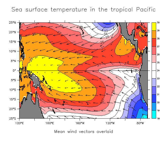
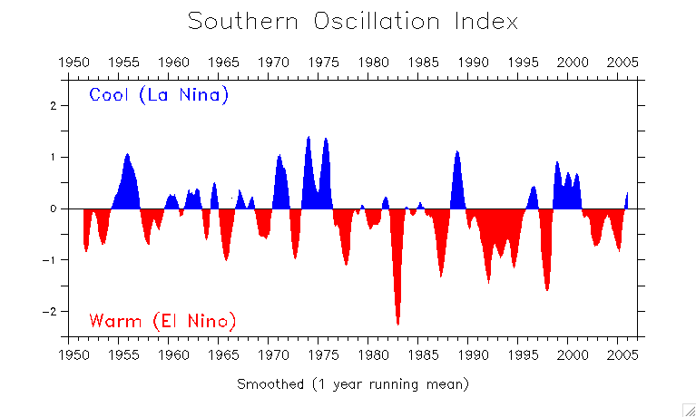
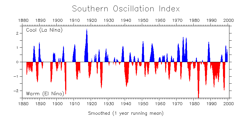
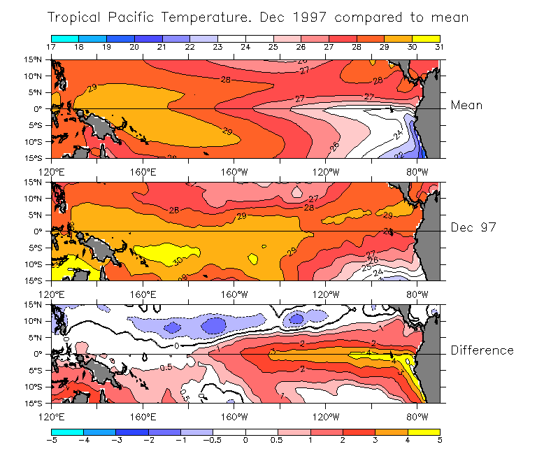