[Created to display at 1024x 768 pixels; also seems to work fine at 800
x 600.]
Peak Lenin
The information here is based on personal experience on Peak Lenin in 1991
plus my reading of several standard sources. You should realize that conditions on
this and any other mountain may vary substantially during any given season and from year
to year. Here I am providing detailed information and a lot of photographs here on
the "standard" route (Razdelnaya Route); I have not attempted to discuss the
others. Likewise, with one exception, I do not deal in detail with how you might get
to the mountain--that is, whom to contact, what services and costs to expect, etc.
Some information relevant to that is in the references provided,
but my personal experience in 1991 was distinctive, and even then the situation regarding
expedition support was changing rapidly. I do know of several reliable service
providers and will eventually post their contact coordinates linked to my main mountain
page. If you want to skip some preliminaries, click here.
One other note for starters, regarding copyright and credits. This
page is © 1999 Daniel C. Waugh as are most of the photographs on it. A few photos
are copies provided me by Kirk Hall and Jim Prichard and are copyrighted under their
names; Asia Travel in Tashkent has given me
permission to copy from their fine topographic map of the mountain. Please feel free
to link to this page without permission or use the material for any non-profit
purpose. Furthermore, if you are wanting to refer your commercial clients to this
page, that is fine. If you wish to use the material otherwise for a commercial
purpose, please have the courtesy to ask me in advance for permission (dwaugh@u.washington.edu); you should contact
Asia Travel for permission to use their map. In general, I always appreciate knowing
when someone is using the material, since that gives me a sense of whether it is worth the
effort to provide it.
My climb on Peak Lenin in 1991 was through an exchange between The
Mountaineers (based in Seattle) and the Soviet Alpine Federation (based in Moscow).
We were a group of relative unknowns who were treated like royalty--the president of the
Federation, Vladimir Shatayev, whose name is tragically tied to Peak Lenin (see below),
met us in Moscow. Several climbing guides were assigned to us, one of them being the
former president of the Federation and one of the first team of Soviet climbers to summit
on Everest, Edvard Myslovsky. We had good conditions; four members of our team
(about half) summited. Unfortunately, I was not one of them. As you probably
know, 1991 was the last year of the existence of the Soviet Union, a fact that has changed
control of access to the mountains in Central Asia. In fact, those changes were
already visible when we were there in July and early August, since the Kyrgyz authorities
had just taken control of the main international base camp on the mountain (Achikh Tash),
and the Russians, who had established and formerly controlled it, were complaining
bitterly about having been ousted. In fact, this seems to have had little effect
either on access or on services for us. Today, there are many independent
entrepreneurs within former Soviet space who can get you to the mountain, the base camp
still functions in pretty much the same fashion, etc. If there are uncertainties,
they may focus primarily on issues of political stability in the region, but so far it
seems Peak Lenin has been little affected by such matters. Unfortunately, the same
cannot be said for access to some other areas in Central Asia that have in recent years
been frequented by international climbers and trekkers.
At 7134 m.(23,405 ft.), Peak Lenin is normally considered one of the easiest 7000-m.
climbs. Indeed its most popular route poses no technical challenges (it is commonly
climbed unroped), and in good weather it can be a relatively warm, if somewhat dull, slog.
The main challenge in good conditions is acclimatization. However, the
mountain also has acquired a different reputation, as the scene of major tragedies,
especially in 1974 and again in 1990. In 1974, it hosted a major gathering of
international climbers (one of the first instances where foreign climbers had been allowed
on peaks in the region). A combination of unusually bad weather (significant
snowfall, then a major storm), an earthquake, and bad judgment resulted in a dozen deaths.
In 1990, an earthquake touched off an avalanche that wiped out Camp II on the
standard (Razdelnaya) route, killing 43 climbers in the worst accident in mountaineering
history. Even if not the scene of tragedy, thanks to high winds on the upper
reaches of the mountain, where one has to endure a very long, exposed slog at above 6300
m., Peak Lenin has defeated climbers who had been successful on much higher and more
demanding climbs. In 1999, unstable weather and heavy snowfall that persisted into
the summer caused some groups to give up on the climb before they even got very far onto
the mountain, although others summitted as the season progressed.
How long does one need to climb the peak? The standard offerings for Peak Lenin
will probably be for trips of a little over three weeks (including travel to and from the
mountain once in the former Soviet space). A typical schedule for the actual
climbing would be some 15-18 days, including any acclimatization. Click here for
details of a planned schedule and then the reality.
Obviously the realities will depend on climbers' fitness, weather and snow conditions,
etc., but this projection seems to be reasonable for an "average" group that was
fit but not necessarily well acclimatized before arriving at base camp.
I can provide suggested gear and food lists, but since personal preferences vary so
much, this may not be very helpful. I tend to climb warm; in 1991 we had what I
would term "warm" conditions--temperature inside tents generally never got below
the 'teens (F.); while it was very windy and cold some of the time on the summit ridge,
layering of heavy polypro, good pile, a light down jacket, and a wind shell seemed
adequate. I had good boots (Lowa Denalis) and used only regular gaiters with them.
There were climbers trying to ski the peak; in a couple of cases I heard they got
frostbitten feet, presumably because their ski boots were not adequately insulated.
There should be no need for a lot of technical gear beyond crampons, ice axe, a light
rope, harness. Although some descriptions of the climb stress crevasses on the route
and recommend roping up for extensive sections of it, plus one or two short places where
there is fixed rope (one might want a belay/rappel device or ascender), in 1991, few
people on the mountain roped on any part of the route, and the section with fixed rope was
negotiable without using it. Obviously one should go prepared for roped glacier
travel. We were fed in the permanent mess hut at base camp and at Camp I, but took
our own freeze dried food for higher on the mountain. Your food requirements would
depend on the agreement you have with your particular outfitter, but most assume you will
bring your own food for above base camp. Stoves such as MSRs work fine even high on
the mountain; ordinary gasoline can be purchased at base camp, although it may not always
be best quality, which may mean frequent cleaning of the stoves. Some outfitters
will offer to provide base camp tents, stoves, and more.
Enough for preliminaries.
Let's assume we have flown into Osh, a sizeable city at the head of
the Ferghana Valley (in Kyrgyzstan, just across the border from Uzbekistan). In
1990, there were significant riots in Osh between the Kyrgyz and Uzbeks; so in 1991 we had
a police escort as we headed from the airport up into the mountains. Now things seem
to be peaceful, although in other parts of Osh province, there has been an only recently
resolved incident involving hostage-taking by armed groups that had crossed over from
Tajikistan. The drive across the mountains to Achikh Tash can take
10-12 hours, with the last two or three on very rough roads/tracks. The route
crosses a 3600 m. pass and goes through the small town of Sary Tash just before turning
west along the Kyzyl Su (Red Water) valley. If one were to follow this valley
directly east, one would arrive at Irkeshtam, which in earlier times was the main portal
on the historic trade route from the west to Kashgar in Xinjiang. Although there is
talk of re-opening that road to normal traffic, we are still waiting for it to
happen. Here is a map showing the route to Achikh Tash
from Osh. This an image map, on which, by following the route with your
mouse, you can find clickable hotspots that will lead you to pictures taken along
the way. Since we flew back to Osh in a helicopter at the end of our climb, some of
the views are from the air.
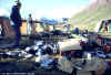
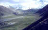 At Achikh Tash (elev. approx. 12,000 ft.), there is
a permanent base camp, with a mess hall, sauna, shop that sells booze, and, for those who
At Achikh Tash (elev. approx. 12,000 ft.), there is
a permanent base camp, with a mess hall, sauna, shop that sells booze, and, for those who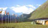 negotiate this ahead with their outfitters,
stand-up tents (in 1991 it was hit or miss whether they leaked; a heavy snow sometimes
caused them to collapse). Here, on the left, is a view looking south across the camp
(note, all photos are thumbnailed--click to enlarge). The photo on the right reveals
the summit of Peak Lenin. Many groups which choose not to pay for the services
at base camp will pitch camp farther up the valley. The map on the left gives
a sense of the topography and shows the location of the camps along
negotiate this ahead with their outfitters,
stand-up tents (in 1991 it was hit or miss whether they leaked; a heavy snow sometimes
caused them to collapse). Here, on the left, is a view looking south across the camp
(note, all photos are thumbnailed--click to enlarge). The photo on the right reveals
the summit of Peak Lenin. Many groups which choose not to pay for the services
at base camp will pitch camp farther up the valley. The map on the left gives
a sense of the topography and shows the location of the camps along 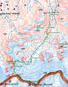 the Razdelnaya Route. The dotted line indicating the
route should be taken as an approximation.
the Razdelnaya Route. The dotted line indicating the
route should be taken as an approximation.
Near base camp, there are many reminders of the tragedies on Peak Lenin.
On a knoll to the northwest is the burial place for the members of the women's climbing
team which got caught in the storm when at the summit in 1974 and all died there.
They were attempting a traverse of the peak on the first all-female ascent. The
leader of the group was Elvira Shataeva, whose husband left this tribute on her grave
marker: "To my loved one full of sunshine and life, the fairy-spirit of the
peaks, a person with a generous soul. Forgive the way it ended."
South from Base Camp through the fields of wild onions is a large boulder, which serves
as the main memorial to climbers who died on the mountain. The large plaque lists
the victims of the 1990 avalanche, including 23 members of a climbing team from St.
Petersburg which was in training for the Himalayas. A group of their freinds is
planning to return to Peak Lenin in the year 2000 to commemorate the tenth anniversary of
their loss. Among those commemorated here is the American Gary Ullin, who died in
1974 on "Peak 19" (=Nineteenth Congress of the Communist Party Peak), shown here
in the last picture in the sequence. He suffocated in his tent, when an avalanche
loosed by the earthquake that year buried it half way up the face.
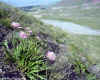 Although it is occasionally blanketed with snow
even during the middle of the summer climbing season, Achikh Tash is usually a green oasis
Although it is occasionally blanketed with snow
even during the middle of the summer climbing season, Achikh Tash is usually a green oasis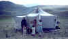 amidst the rubble and ice of the surrounding
peaks. Apart from the wild onions, there are many other wild flowers. Eons
ago, glacial action carved the valley; the old terminal moraine is just below the base
camp, dotted with small lakes. Over time, vegetation took hold and covered the
valley floor, making it ideal pasture land for the Kyrgyz herders who were there long
before the first Russian explorers espied the imposing peak they named for the Russian
Governor General of Turkestan, Kaufman, and which we now know as Lenin (probably re-naming
will occur eventually, but certainly not to honor once more the administrator of the
Empire's Central Asian
amidst the rubble and ice of the surrounding
peaks. Apart from the wild onions, there are many other wild flowers. Eons
ago, glacial action carved the valley; the old terminal moraine is just below the base
camp, dotted with small lakes. Over time, vegetation took hold and covered the
valley floor, making it ideal pasture land for the Kyrgyz herders who were there long
before the first Russian explorers espied the imposing peak they named for the Russian
Governor General of Turkestan, Kaufman, and which we now know as Lenin (probably re-naming
will occur eventually, but certainly not to honor once more the administrator of the
Empire's Central Asian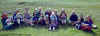 colonies). It is traditional for the Kyrgyz to welcome visitors into their homes; if one
goes down the valley a ways from Base Camp, one may be invited into a yurt for ayran
(yoghurt), nan (flat bread), tea, and perhaps even kumys (fermented
mare's milk). It is probably a good idea to check ahead of time with someone at base
camp and not just arrive unannounced. Note that since the whole area around Base
Camp is pasture, one should not drink unfiltered/unboiled water from the streams.
colonies). It is traditional for the Kyrgyz to welcome visitors into their homes; if one
goes down the valley a ways from Base Camp, one may be invited into a yurt for ayran
(yoghurt), nan (flat bread), tea, and perhaps even kumys (fermented
mare's milk). It is probably a good idea to check ahead of time with someone at base
camp and not just arrive unannounced. Note that since the whole area around Base
Camp is pasture, one should not drink unfiltered/unboiled water from the streams.
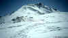
For acclimatization, many parties will do a day ascent of Peak Petrovsky (approx. 4700
m./over15,000 ft.) which rises just to the west of base camp. The ascent involves
scrambling up to a saddle and then climbing along the ridge, where one steep section
likely requires crampons and ice axe, and possibly a rope. Above that, it is a
gentle ascent to the summt, from which there is a grand panorama across to Peak Lenin on a
clear day.
 Back at base camp, you sort gear. Since you
likely will use Camp I as advance base, you will want to take everything up that you need
for the
Back at base camp, you sort gear. Since you
likely will use Camp I as advance base, you will want to take everything up that you need
for the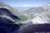 mountain. Either this means
several loads or, as most do, paying for the helicopter to do the hauling. If you do
the latter, it is a good idea to have one of your team accompany the load to Camp I
(and later do the reverse when you leave the mountain). From base camp to CI takes
an estimated 4-6 hours, although the first time, if loaded and still not well
acclimatized, may take longer. Our group actually camped just below Travelers' Pass
(4150 m.) which must be crossed before dropping down to the nearly level Lenin
Glacier. The hike up to the pass
mountain. Either this means
several loads or, as most do, paying for the helicopter to do the hauling. If you do
the latter, it is a good idea to have one of your team accompany the load to Camp I
(and later do the reverse when you leave the mountain). From base camp to CI takes
an estimated 4-6 hours, although the first time, if loaded and still not well
acclimatized, may take longer. Our group actually camped just below Travelers' Pass
(4150 m.) which must be crossed before dropping down to the nearly level Lenin
Glacier. The hike up to the pass  offers
good views back down Achikh Tash, a lot of wild flowers (even at the otherwise stark
summit of the pass), and then dramatic views down
offers
good views back down Achikh Tash, a lot of wild flowers (even at the otherwise stark
summit of the pass), and then dramatic views down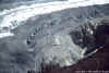 to the Lenin Glacier moraine and across to the peak. Also it is a
good location to get telephoto shots of the route (one or two reproduced later). The
trail leading down to the moraine can be seen on the left side of the photo. Once
down, there is a relatively short walk along the moraine before going out onto the glacier
itself. For those who have not been on a large relatively low angle glacier such as
this before, a few warnings are in order. A fresh snowfall can make it a treacherous
place, but in normal conditions, the
to the Lenin Glacier moraine and across to the peak. Also it is a
good location to get telephoto shots of the route (one or two reproduced later). The
trail leading down to the moraine can be seen on the left side of the photo. Once
down, there is a relatively short walk along the moraine before going out onto the glacier
itself. For those who have not been on a large relatively low angle glacier such as
this before, a few warnings are in order. A fresh snowfall can make it a treacherous
place, but in normal conditions, the 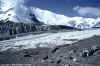 ice is
firm and any crevasses obvious. Most people would not rope up. The hardest
part of getting to CI may be the one or two stream crossings,
ice is
firm and any crevasses obvious. Most people would not rope up. The hardest
part of getting to CI may be the one or two stream crossings, since such glaciers usually have streams running their length that have
even carved little canyons. Crossing them can require care, as to fall in may mean
being swept down, eventually perhaps to disappear under the ice....As the picture here
shows, it was possible to jump the largest stream on the Lenin Glacier; after that, the
way was pretty smooth all the way to CI.
since such glaciers usually have streams running their length that have
even carved little canyons. Crossing them can require care, as to fall in may mean
being swept down, eventually perhaps to disappear under the ice....As the picture here
shows, it was possible to jump the largest stream on the Lenin Glacier; after that, the
way was pretty smooth all the way to CI.
 At least in 1991, there was regular helicopter
service between base camp and CI, although not according to a fully predictable schedule,
since
At least in 1991, there was regular helicopter
service between base camp and CI, although not according to a fully predictable schedule,
since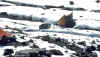 the same copter also serviced one of
the base camps below Peak Communism. When there are a lot of climbers on the
mountain, getting your load in queue for the copter can be a problem--those who push
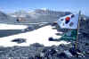
hardest may be end up in front of the line. (In case you wonder, yes, there was a Korean
expedition on the peak that year.) Camp I is located on a moraine in the middle of the
glacier at about 4300 m/14,000 ft. There is a semi-permanent hut there used by the
guides; generally a latrine is erected straddling one of the crevasses. In 1991, as
the season wound down and the glacier melted, one fine day while in use the latrine fell
into the crevasse taking its occupant with it (he survived and understandably may have
found the whole thing amusing only after he was home...). During the day there
generally is enough melting, so that one can get water and not have to melt snow.
the same copter also serviced one of
the base camps below Peak Communism. When there are a lot of climbers on the
mountain, getting your load in queue for the copter can be a problem--those who push
hardest may be end up in front of the line. (In case you wonder, yes, there was a Korean
expedition on the peak that year.) Camp I is located on a moraine in the middle of the
glacier at about 4300 m/14,000 ft. There is a semi-permanent hut there used by the
guides; generally a latrine is erected straddling one of the crevasses. In 1991, as
the season wound down and the glacier melted, one fine day while in use the latrine fell
into the crevasse taking its occupant with it (he survived and understandably may have
found the whole thing amusing only after he was home...). During the day there
generally is enough melting, so that one can get water and not have to melt snow.
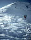
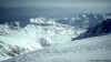
Now let's look more closely at the route as seen from Base Camp. The first two
pictures (courtesy of Asia Travel) are a topographic map and a schematic showing both the
"normal" Razdelnaya Route (on the right) and the Lipkin Route. Then there
is a shot with a detail of the latter, and a photo of the former taken from Base Camp,
with a telephoto detail of the lower part of the route.
From Camp I to Camp II. Asia Travel's time estimates are 1-2 hours from CI to the
base of the slope, 2-3 hours to do most of the serious climbing to 5100 m., and another
1-2 hours, including dropping down slightly before the final ascent, to reach CII.
They stress the presence of crevasses along much of the route and recommend doing it all
roped. Normally the steepest part of the climb (at the beginning of the slope) has a
fixed rope for up to 100 m. In 1991, this part of the route was done largely
unroped; the crevasses (this was early August) were not a problem. Note however
that once up above the steep slope, there is some potential avalanche danger along much of
the traverse. After the snowfall for a couple of days in the middle of our climb,
avalanches along the face came down just about to the route. Major fresh snow and
an earthquake (such as touched off the avalanche that destroyed Camp II in 1990) could
cause the whole face to let loose. The photos here start below the steep slope and
then continue from above it. In the fourth picture, climbers can be seen on the left
approaching CII. The ice cliffs in the cirque above Camp II and the corniced slope
below the pass and sweeping around to Razdelnaya Peak have the potential to avalanche (see
photo for one of "small" ones that came down during and after the snowstorm we
sat out at CII). It is very important to pitch camp well up on the scree slope to
the right, to avoid being in the path of a major slide such as that of the 1990 tragedy).
Camp II to Camp III. Asia Travel's times for this section include 1.5-2 hours to
the ridge above CII, 2-4 hours more to CIII either over the top of Razdelnaya (6210 m.),
or along the slope just below it above the cirque. In 1991, the gully above CII was
a bit icy before the fresh snow; however, it did not require more than crampons and an ice
axe. The snow below Razdelnaya can have breakable crust with powder underneath and
thus take a lot of energy. The photos here show the route up the gully, a telephoto
of Razdelnaya, in which the track can be seen, then climbers ascending it. From
Razdelnaya one looks down 100 m. or so to the saddle and up along the ridge, with the
summit hidden off to the left (photo 4). Camp III is very exposed; so it is a good
idea to dig in and anchor tents well.
 Above CIII. Apart from the thin air above
6000 m.and the fact that it can be wind-blown and icy, there is nothing particularly
difficult about the
Above CIII. Apart from the thin air above
6000 m.and the fact that it can be wind-blown and icy, there is nothing particularly
difficult about the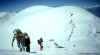 slope
leading out of CIII (on the right the view is down to CIII and across to Razdelnaya).
Asia Travel estimates it takes 1.5-3 hours to reach the shoulder at its top.
One then passes a bit of a depression where some establish a CIV. In the
photo, I am shown with a Russian tent which is probably typical of the ones in which the
Soviet women's team perished in the 1974 accident. When I was descending from my
unsuccessful summit attempt, the three inhabitants of the tent kindly allowed me to
slope
leading out of CIII (on the right the view is down to CIII and across to Razdelnaya).
Asia Travel estimates it takes 1.5-3 hours to reach the shoulder at its top.
One then passes a bit of a depression where some establish a CIV. In the
photo, I am shown with a Russian tent which is probably typical of the ones in which the
Soviet women's team perished in the 1974 accident. When I was descending from my
unsuccessful summit attempt, the three inhabitants of the tent kindly allowed me to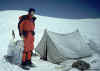 spend the night there. It was cramped but
warm enough even though I did not have a sleeping bag, since the weather was benign.
For many climbers, doing a short day from CIII and establishing CIV may
substantially improve the possibility of summiting, as the ridge beyond that point seems
to go on forever.
spend the night there. It was cramped but
warm enough even though I did not have a sleeping bag, since the weather was benign.
For many climbers, doing a short day from CIII and establishing CIV may
substantially improve the possibility of summiting, as the ridge beyond that point seems
to go on forever.
 Asia Travel estimates another 3.5 to 6.5 hours from
from the shoulder to the summit. This involves traversing a fairly flat plateau,
then ascending the ridge as shown in the photo (there are some climbers in the upper
center, giving a sense of the huge scale). In 1991 in this stretch there was a
fierce headwind which was very draining. Asia Travel notes that beyond is the
"Knife," where there may be fixed rope. Clearly above my high
Asia Travel estimates another 3.5 to 6.5 hours from
from the shoulder to the summit. This involves traversing a fairly flat plateau,
then ascending the ridge as shown in the photo (there are some climbers in the upper
center, giving a sense of the huge scale). In 1991 in this stretch there was a
fierce headwind which was very draining. Asia Travel notes that beyond is the
"Knife," where there may be fixed rope. Clearly above my high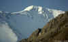 point of approx. 6500 m.(the snow dome upper left
center) there was a ridge that had to be ascended before actually getting onto the huge
summit plateau. Here all I can offer for the last part of the route is a telephoto
from Achikh Tash, where that ridge is right at the point where the peak is obscured by the
diagonal slope in the foreground. It is important to realize that in poor visibility
the summit plateau can be a featureless trap. This is probably the main reason that
the women's team in 1974 did not attempt to descend before it was too late. In 1991,
Edvard Myslovsky strolled to the summit by himself in bad conditions, managing to pick up
along the way some lost climbers, whom he safely herded down. (Although it is likely
other groups or the Russian guides on the mountain will have placed some wands, having
your own for the climb may make sense.) A few days later, he went back up with the
three members of our group who summited in perfect weather.
point of approx. 6500 m.(the snow dome upper left
center) there was a ridge that had to be ascended before actually getting onto the huge
summit plateau. Here all I can offer for the last part of the route is a telephoto
from Achikh Tash, where that ridge is right at the point where the peak is obscured by the
diagonal slope in the foreground. It is important to realize that in poor visibility
the summit plateau can be a featureless trap. This is probably the main reason that
the women's team in 1974 did not attempt to descend before it was too late. In 1991,
Edvard Myslovsky strolled to the summit by himself in bad conditions, managing to pick up
along the way some lost climbers, whom he safely herded down. (Although it is likely
other groups or the Russian guides on the mountain will have placed some wands, having
your own for the climb may make sense.) A few days later, he went back up with the
three members of our group who summited in perfect weather.
 As the final picture shows, the view back in the
direction of Achikh Tash even from short of the summit is spectacular. Everything is
covered with fresh snow down below (Achikh Tash got a foot or so); beyond can be seen the
Kyzyl Su valley, stretching East-West, one of the important branches of the famous Silk
Road.
As the final picture shows, the view back in the
direction of Achikh Tash even from short of the summit is spectacular. Everything is
covered with fresh snow down below (Achikh Tash got a foot or so); beyond can be seen the
Kyzyl Su valley, stretching East-West, one of the important branches of the famous Silk
Road.
For the record, note that in 1991 while I was waiting for the helicopter out of CI at
the end of our climb, a Russian guide, Gleb Sokolov, established what was then a speed
record on the mountain--12 hours, round trip from Camp I to the summit on
Razdelnaya Route. Another year and in another place he won the Soviet speed climbing
championship.
Back to my mountain
travel home page.
Copyright © 1999 Daniel C. Waugh. This page was posted October 27, 1999.
 At Achikh Tash (elev. approx. 12,000 ft.), there is
a permanent base camp, with a mess hall, sauna, shop that sells booze, and, for those who
At Achikh Tash (elev. approx. 12,000 ft.), there is
a permanent base camp, with a mess hall, sauna, shop that sells booze, and, for those who negotiate this ahead with their outfitters,
stand-up tents (in 1991 it was hit or miss whether they leaked; a heavy snow sometimes
caused them to collapse). Here, on the left, is a view looking south across the camp
(note, all photos are thumbnailed--click to enlarge). The photo on the right reveals
the summit of Peak Lenin. Many groups which choose not to pay for the services
at base camp will pitch camp farther up the valley. The map on the left gives
a sense of the topography and shows the location of the camps along
negotiate this ahead with their outfitters,
stand-up tents (in 1991 it was hit or miss whether they leaked; a heavy snow sometimes
caused them to collapse). Here, on the left, is a view looking south across the camp
(note, all photos are thumbnailed--click to enlarge). The photo on the right reveals
the summit of Peak Lenin. Many groups which choose not to pay for the services
at base camp will pitch camp farther up the valley. The map on the left gives
a sense of the topography and shows the location of the camps along  the Razdelnaya Route. The dotted line indicating the
route should be taken as an approximation.
the Razdelnaya Route. The dotted line indicating the
route should be taken as an approximation.


