|
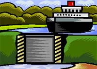
Navigation and the Watershed The operation of the Lake Washington Ship Canal (LWSC) project, including the Hiram A. Chittenden Locks uses a tremendous amount of water to support navigation, fish passage and water quality. With so many competing interests for the water including M&I water supply and water needed to support anadromous fisheries, trade-offs are inherent in how the overall system is managed. Balancing the human use activities of water supply, navigation and commercial fishing with broader environmental objectives is challenging. Not only are there numerous stakeholder groups but also many environmental statues that need to be addressed. The Lake Washington Ship Canal project encompasses the Hiram A. Chittenden Locks and associated lakes of Lake Washington and Lake Union. The project includes an 8-mile ship canal, large and small lock, salt-water drain, spillway and fish ladder. The hydraulic effects of the Locks include the Lake Washington Basin, Cedar River Basin and the Sammamish sub-basin. The Lake Washington hydrologic system drains 706 square miles and is comprised of tree major sub-basins: the Cedar (188 square miles) the Sammamish sub-basin (240 square miles) and the Lake Washington sub-basin (181 square miles). The Cedar River flows into the southern end of Lake Washington, approximately 12 miles downstream of the Landsburg Diversion, at the City of Renton. The Cedar River was diverted into Lake Washington in approximately 1914 by a commercial waterway district, concurrently with the construction of the Ship Canal and the Locks and the lowering of Lake Washington by 9 feet. The history of the project is fascinating and provides a reference point for how public values have shifted from meeting purely economic needs in the early 1900s to balancing environmental and economic needs over the past 30 years. The Lake Washington Project was initially undertaken by local businessmen and municipalities in the late 1800s to improve transportation of timber and coal from the foothills of the cascades to Seattle. In addition to water transportation, other advantages of the envisioned project would include:
The local efforts were unsuccessful due to financial and engineering difficulties and eventually assistance from the federal government was sought. The Lake Washington Ship Canal project as it is known today, was authorized by congress in 1910 to provide a navigable link between the salt water of Puget Sound and the fresh water of Lake Union and Washington. The Army Corps of Engineers completed construction of the project in 1916.
The navigation improvement not only provided safe fresh water moorage for commercial vessels, but also provided inexpensive transportation to the communities surrounding Lake Washington. Today the project is used for both commercial navigation and recreational vessels. The total number of commercial vessels using the Locks averages about 11,000 per year and includes cargo, fishing vessels, tows and other commercial craft. The number of recreational or pleasure craft averages 55,000 per year, the highest recreational use of any lock system in the country. Operation of the project takes into account other project purposes including storm damage reduction, water conservation, water quality and fisheries. As part of the authorizing documents, Lake Washington is to be held between elevation 20’ (during the winter months for flood control and storm damage reduction and 22’ (for water conservation during the mid-spring and summer). The 8- mile-long Ship Canal links Puget Sound with the fresh waters of Salmon Bay, Lake Union, and Lake Washington. The Locks protect water quality from potential impacts of salt-water intrusion into Lake Washington. In accordance with Department of Ecology guidelines saltwater cannot exceed 1 part per million at the Mount Lake Bridge. The Cedar River is now the major tributary in the basin (approximately 65% of freshwater input to Lake Washington) with significant runs of sockeye, chinook and coho salmon and steelhead trout. The Lake Washington inflow to the Ship Canal from 1980-1995 has been only 80% of the long-term historical average (1939-1995). This combined with the recognition of need for additional flows in the lower Cedar for anadromous fisheries, additional flows over the spillway for out migrating juvenile salmon, and providing attraction flows for returning adult salmon must all be factored into how the project is managed today. Over the past 20 years there have been a variety of committees and commissions established to help determine how best to manage the trade-offs inherent in water supply. The "water budget" is so tight in the basin that management decisions from stakeholder groups must be made on a continual basis. The following presents a "water budget" for the LWSC project which breaks down the different uses of water at the locks over a three month period between May and July.
The Corps must operate the project to meet the "demand" flows above and operate the project to stay within the authorized lake levels. During the late spring, once the threat of winter storms passes and the majority of smolts have migrated out of the system, the Corps begins refill of the lake to the conservation height, 22’, in order to supplement flows for the locks during the months of August and September. Other competing uses of water during this critical time of the year are the flows on the Cedar River for M&I water supply and flows for anadromous fisheries.
|