Development of a Model for the Assessment of Biogeochemical Dynamics and
Restoration Strategies in Penn Cove
Supplemental Resources
for the Northwest Straits Foundation Application
for funding from USEPA Region 10
Puget Sound Scientific Studies and
Technical Investigations Assistance Program
Submitted March 8, 2010
![]()
|
|
|
|
Proposal Submissions |
|
|
|
|
|
Attachment
A – Maps |
|
|
Attachment
B – Budget Narrative |
|
|
Attachment
C – Logic Model |
|
|
|
|
|
Supplemental Items Referenced in the Proposal |
|
|
|
|
|
|
|
|
Aerial
photo of Penn Cove from Google Earth. |
|
|
|
|
|
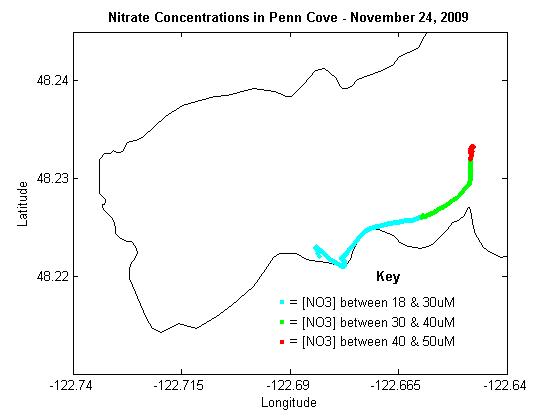
Plot
of surface nitrate concentrations in Penn Cove from 11/24/09 (Data
collected with Satlantic SUNA nitrate sensor during test research cruise) |
Why
concern ourselves with Penn Cove? Check
out this Washington
State Department of Ecology poster by Maloy et al., (2007) that assesses
the environmental problems of Penn Cove.
Just how does Penn Cove rank in Puget Sound? |

Other
Relevant Graphics
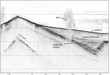
![]() Plot of Shallow Seismic Reflection Profile Showing Gas Emanating
from Sediments of Penn Cove
Plot of Shallow Seismic Reflection Profile Showing Gas Emanating
from Sediments of Penn Cove
|
(Data collected on 2/12/10 during a USGS seafloor mapping
expedition) |
|
|
|
|
|
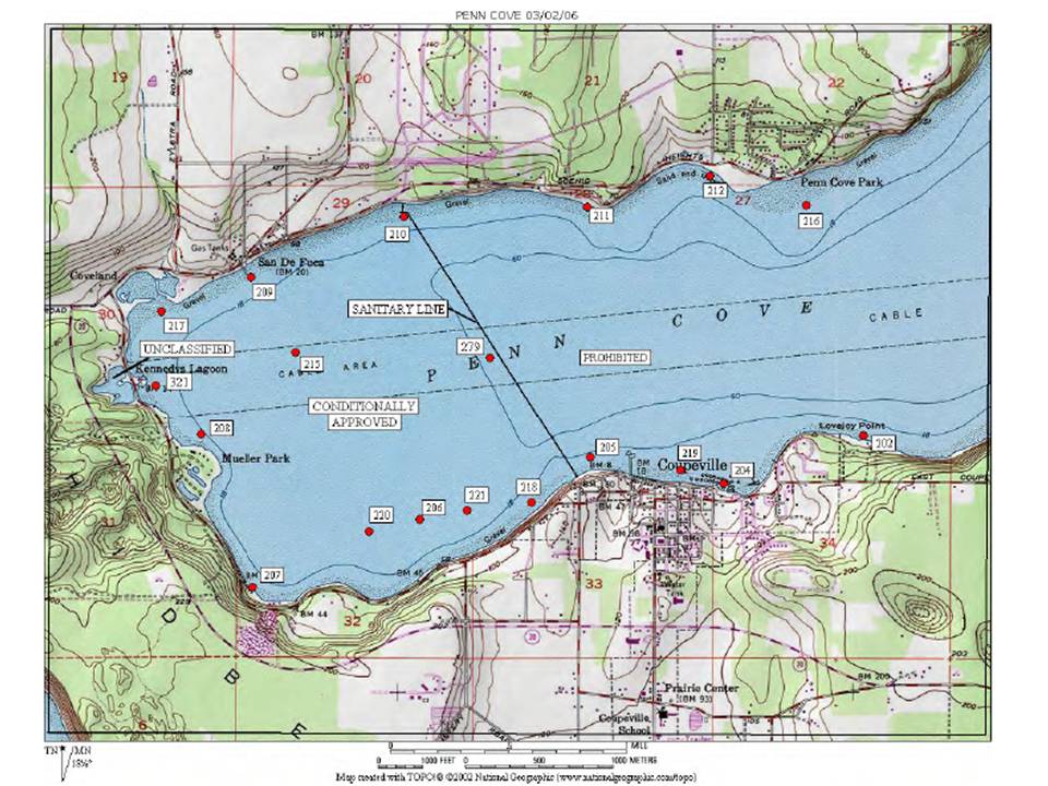
Map of Penn Cove depicting “sanitary line” dividing areas that
are open and closed to shellfish harvest |
|
|
(Click on thumbnail below for larger image)
|
|
|
WA State Department
of Health, 2008. |
Image
courtesy of Eric Grossman. |
Maps
depicting land use, location of “at risk pocket” estuaries, net longshore drift
directions, and reasons for 303d impaired water listing in and around Penn Cove
Selected Online References
|
|
|
||
|
Bill,
BD., Cox, FH., Horner, RA., Borchert, JA., and Trainer, VL. 2006. The
first closure of shellfish harvesting due to domoic acid in Puget Sound,
Washington, USA. African Journal of Marine Science, 28(2): 435-440 |
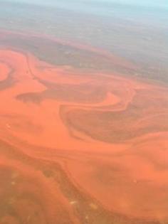
A red tide algae bloom in Penn Cove on 5/8/04. Photo by Mary Jo Adams |
||
|
|
|||
|
Coastal Geologic Servcies, Inc. 2004.
Shoreline
Master Program – Phase 1 Shoreline Analysis Report. Town of Coupeville
Shoreline Master Program. |
|||
|
. |
|||
|
Environmental Health Program
Services, Island County Public Health. |
|||
|
|
|||
|
Island County Council of Governments. 2008. Island County Sustainability Resolution. |
|||
|
|
|||
|
. |
|||
|
Island County Public Works Department. 1997. North
Whidbey Watershed Nonpoint Pollution Action Plan. 47 pp. |
|||
|
|
|||
|
Klinger, T., Fluharty, D., Byron, C., Evans, K. and Coyle, J.
2007. Assessment
of coastal water resources and watershed conditions at Ebey’s Landing National
Historical Reserve (Washington). Natural Resource Technical Report
NPS/NRWRD/NRTR—2007/369, U.S. Department of Interior. |
|||
|
. |
|||
|
Maloy, C., Stutes, A., Grantham, B., Bos, J., and Albertson,
S. 2007. Long
term monitoring of Puget Sound, Grays Harbor and Willapa Bay: status and
trends in water quality from 2001-2005. WA State Department of Ecology. |
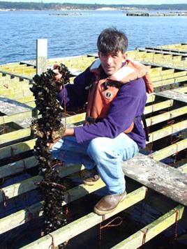
Mussels grown in
Penn Cove by Penn
Cove Shellfish, LLC. |
||
|
|
|||
|
Northwest
Fisheries Science Center. 1999. Red Tides: West Coast newsletter on
marine biotoxins and harmful algal blooms. |
|||
|
|
|||
|
. |
|||
|
Pederson, D. 2009. Nearshore
Report: The Work of Island County MRC.
Island County Marine Resources Committee. |
|||
|
|
|||
|
Puget Sound Partnership.
2009. Puget
Sound Action Agenda. Protecting and Restoring the Puget Sound
Ecosystem by 2020. |
|||
|
|
|||
|
Puget Sound Partnership Science Panel. 2008. PSP Biennial Science Work
Plan 2009-2011, December 1, 2008. |
|||
|
. |
|||
|
Redman, S., Myers, D., and Averill, D. 2005. Regional
nearshore and marine aspects of salmon recovery in Puget Sound. Puget Sound Action Team. [Selected
maps of relevance to Penn Cove] |
|||
|
. |
|||
|
Trainer, V. 2002. Harmful
algal blooms on the U.S. west coast.
North Pacific Marine Science Organization. . |
|||
|
|
|||
|
Trainer, VL., Adams, NG., Bill, BD.,
Anulacion, BF., and Wekell, JC. 1998. Concentration and
dispersal of a Pseudo-nitzschia bloom in Penn Cove, Washington, USA.
Natural Toxins. 6(3-4): 113-125. |
|||
|
. |
|||
|
Washington State Department of Ecology. No date. PSAMP Monitoring – What
we’ve found. |
|||
|
. |
|||
|
Washington State Department of Ecology. 2009. Fact
sheet for NPDES permit WA-002937-7 Coupeville Wastewater Treatment Plant. |
|||
|
. |
|||
|
Washington State Department of Ecology. 2010a. Fact
sheet for NPDES permit WA-002938-6 Penn Cove Wastewater Treatment Plant. |
|||
|
. |
|||
|
WA State Department of Ecology. 2010b. Long-term marine
water quality data – PNN001 Penn Cove Park (Whidbey
Island). [Map of sampling station location] |
|||
|
. |
|||
|
Washington State Department of Health. 2009. Penn Cove
Annual Growing Area Review, 2008. |
|||
|
|
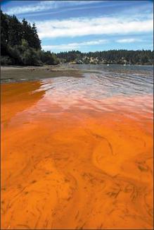
A red tide algae bloom in Penn Cove on 8/14/06. |
|
|
|
Miscellaneous Photos |
From Phinney, 2006. Photo by Roy Goodall. |
|
|
|
|
|
|
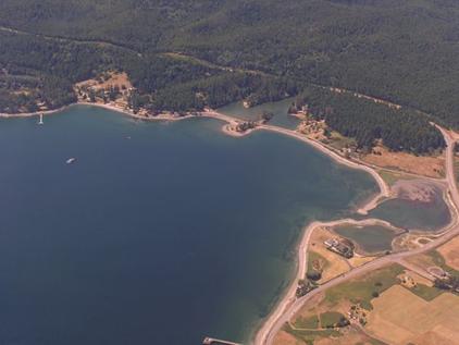
Photo
of the northwest corner of Penn Cove.
This area is subject to periodic harmful algal blooms, but is also
cited as a good place to harvest clams in the intertidal zone. Photo from Washington
State Department of Fish and Wildlife. |
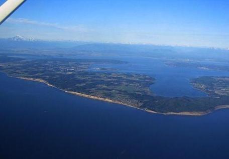
Whidbey
Island from the West featuring a view of Penn Cove and Saratoga Passage
beyond. Photo from the Pacific
Flying Club. |
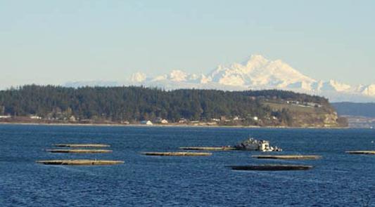
Photo of the mussel rafts of Penn
Cove Shellfish, LLC., with Mt. Baker in the background.
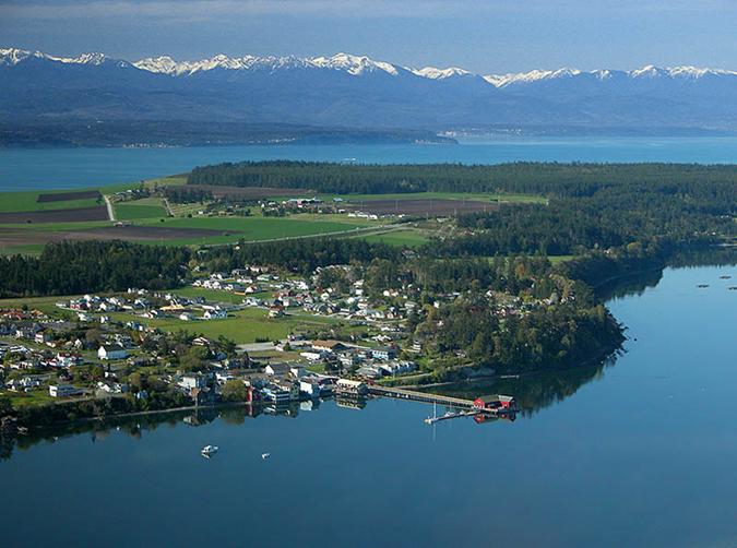
Photo of Coupeville, Penn Cove and part of Ebey’s Prairie with
Admiralty Inlet and the Olympic Mountains
behind. Photo by Craig Sullivan.
Return to Robert
Turner’s Home Page