| MARGINS | STRATAFORM | EuroStrataform | Molokai | The Sea |

The FOBS that is under development right now has a number of new features that not only makes it a better instrument for suspended-sediment concentration monitoring, but also makes it significantly easier to use. It is still under development, and the user interface part is the major part of the project that needs attention at this point.
The modifications include:
- Changing the light source, which means that all channels now have equal and synchronous light so that gains for each channel are relatively equal (which was not the case with the previous FOBS).
- Making the two probes in the same style (the previous version had a "small" probe which was slim and fibers ground to 45 deg and a large probe which was rather clunky so that the fiber pairs stuck straight out). Currently there are still 2 probes for flexibility, but both are the "slim" version to prevent inconsistency in the vertical profile because of the change in probe type.
- An added wireless link (and reduced power consumption) so that the unit can be used with or without a shore cable. Power can be supplied through a rechargeable battery pack (I used a small 6" x 18" underwater power pack and was fine for 2+ days of continuous 10 hz data). Data is logged internally, and can be sent up a shore cable. The wireless link allows for a transfer of data through the antennae also.
- The onshore computer (basic laptop with wireless card and browser software) only needs a WIFI card and data can be looked at in near-real time (presently it takes about a minute or two for a plot to generate at the instrument and sent to the laptop).
- Time syncing is done through a GPS dongle on the laptop, so that as long as the instrument antenna is above water, syncing is continuous with GPS time. Alternately, if time sync is provided over ethernet, the instrument could also sync up that way.
The unit we have presently (the prototype) is also configured to accept data from a pressure sensor and electromagnetic current meter. There is another channel available, but limited endcap space for another instrument.

|

|
| calibration tank with the motor turned off | calibration tank, sensor, motor |

|

|
| Dungeness Spit conditions | FOBS instrument response |
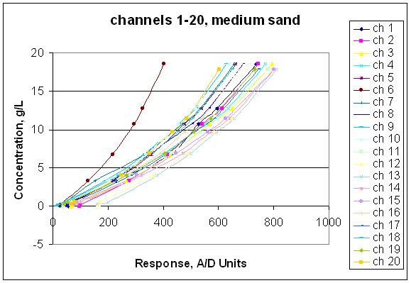
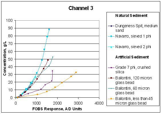
Calibration for FOBS took place January-May 2005. In these experiments we used synthetic and natural sand from different locations and conditions. The results show that FOBS recognizes many different grain sizes and that natural and synthetic sands behave differently.
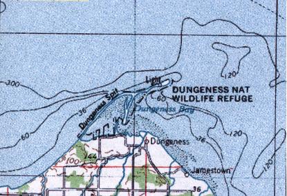
In this experiment, a small tripod (approximately 4’ high) was deployed in the intertidal zone at the base of Dungeness Spit, WA. Data collected included time series of: pressure, two components of velocity, and 20 estimates of suspended-sediment concentration in a vertical array.
The instrument is under development, funded by the National Science Foundation, and this experiment fulfills two objectives:
- Test the developmental instrument in an energetic environment.
- Provides initial data to address nearshore transport processes in the Straits of Juan de Fuca. This data is used to evaluate the currents along the shoreline, the energy of the waves, and the net flux of sediment along the shore. We used this data in an initial investigation of the oceanographic processes responsible for sediment transport along the Straits.
The instrument set was deployed and collected at or near low tide.
Day 1. January 22, 2005
Afternoon: preparation and building/testing of instrumentation.
Evening: deployment of small tripod at approximately ~0.0m MLLW. Sand sample seabed at site. Survey cross-sectional bathymetry at site.
Night: Radio-link and internal data collection throughout night and through next day
Day 2. January 23
Afternoon/Evening: retrieve tripod, remove battery pack and take up to work area to replace batteries. Re-deploy tripod at ~-0.5m MLLW. Sand sample seabed at site. If any reason to suspect beach changes, re-survey cross-section.
Night: Radio-link and internal data collection throughout night and through next day.
Day 3. January 24
Afternoon/Evening: retrieve tripod, remove battery pack.
Depending on weather conditions experienced and equipment performance, we may or may not want to redeploy for one more tidal cycle. We will re-survey the site at the end of the experiment.
| Home |
Last modified: 9/13/2005 4:12 PM