
Abyssal Circulation in the Northeast Pacific
For a number of years, I have been looking at flow in the deep eastern North Pacific on a variety of horizontal scales, and at a variety of depths from the upper to abyssal ocean. In this project, I use a formally overdetermined "hydrographic" inverse model to determine the absolute geostrophic flow consistent with conservation of potential vorticity and salinity. This inverse model incorporates a functional representation of diapycnal mixing motivated by observations of fine- and micro-structure turbulent dissipation rates (that is to say: it is bottom intensified and a function also of the "roughness" of the seafloor). One of the surprising results is that the rates of both diapycnal and along-isopycnal (strictly, neutral surface) mixing are extremely small in this region. Consequently, the abyssal overturning is much thinner than conventionally understood. Only 5% of the bottom water (i.e., the Lower Circumpolar Deep Water) is converted to the overlying North Pacific Deep Water during one pass along streamlines through the Northeast Pacific Basin (a north-to-south sense of flow).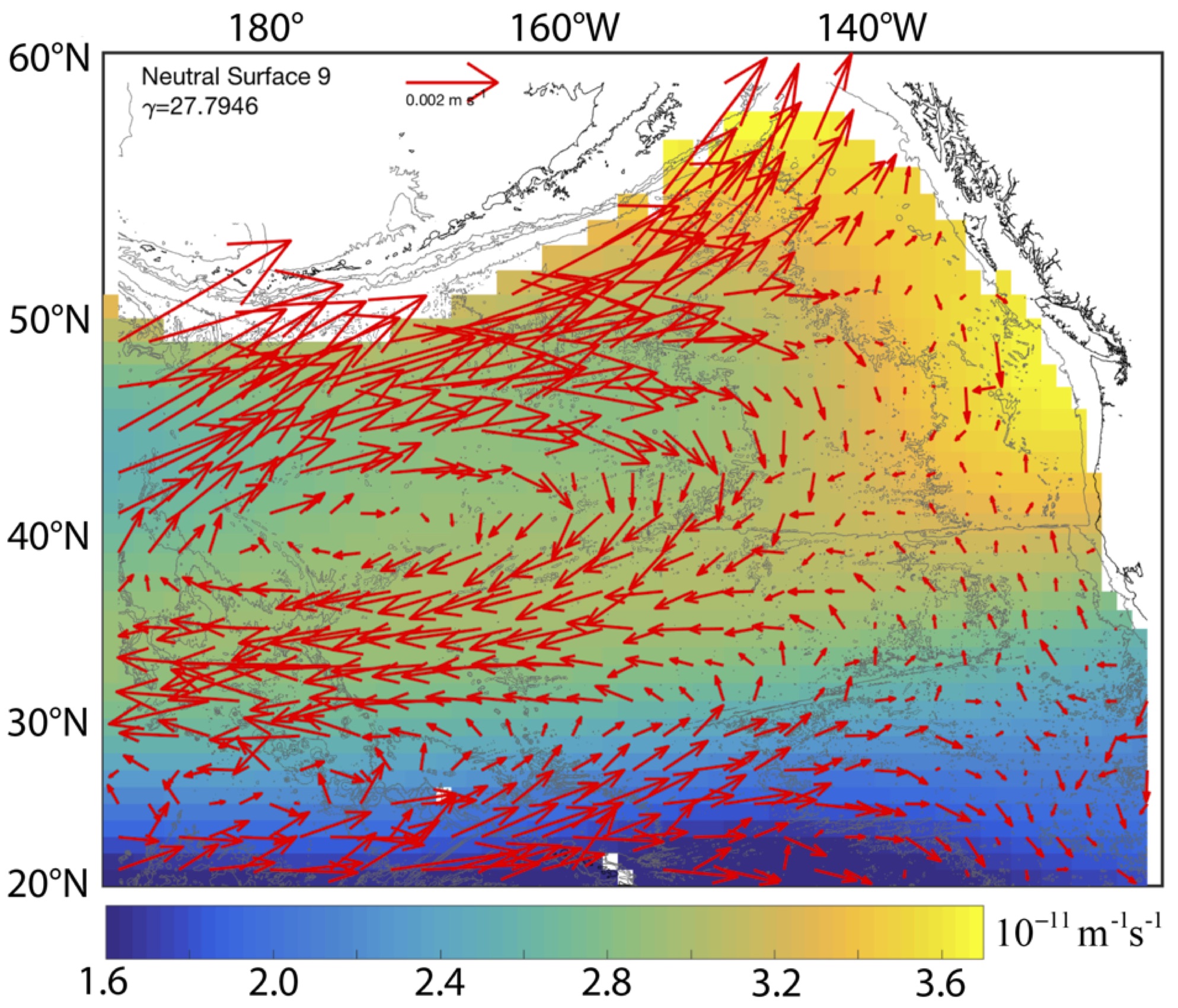
Circulation Atlas of the Deep Northeast Pacific Basin
(includes inverse circulation and property field download)
Absolute geostrophic flow vectors superimposed on large-scale potential vorticity (i.e., the component related to the stratification) from Hautala (2018). This neutral surface lies in the North Pacific Deep Water at depths between 1400-1600 m. Because of a weak rate of mixing, flow largely conserves potential vorticity (PV) and so the ridge in PV that lies roughly along the Mendocino Fracture Zone separates circulation systems to its north and south.
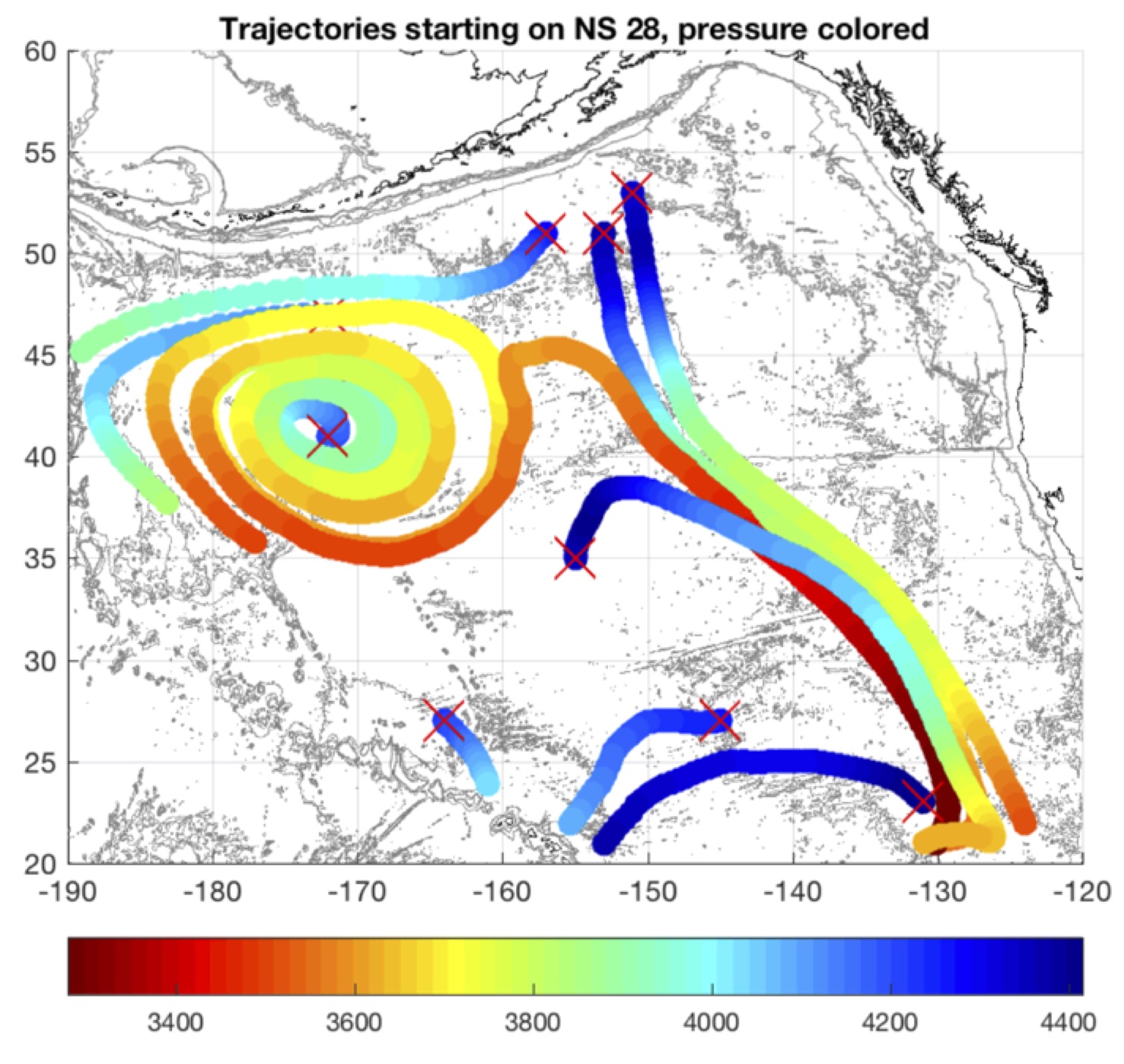 Another visualization of the absolute geostrophic flow, this time in the context of the overturning circulation, also from Hautala (2018). This neutral surface lies in the Lower Circumpolar Deep Water at depths between 3500-3900 m. The trajectories show the positions of water parcels released at the red "x" marks as they respond to purely advective processes (i.e., no lateral diffusion, but there is a mean diapycnal velocity related to small-scale turbulent mixing). The colors show pressure, and it is apparent that water parcels rise by less than 1 km as they flow from north to south, another way of understanding how the abyssal circulation in this region is "thin."
What causes the double silica maximum in this region?
A collaborative project with geochemist Doug Hammond at USC examines the relationship between this "thin" abyssal overtuning circulation pattern and the double silica maximum. The inverse model flow fields were used as the basis for a steady-state stochastic Lagrangian simulation of silica, carbon and radiocarbon fields.
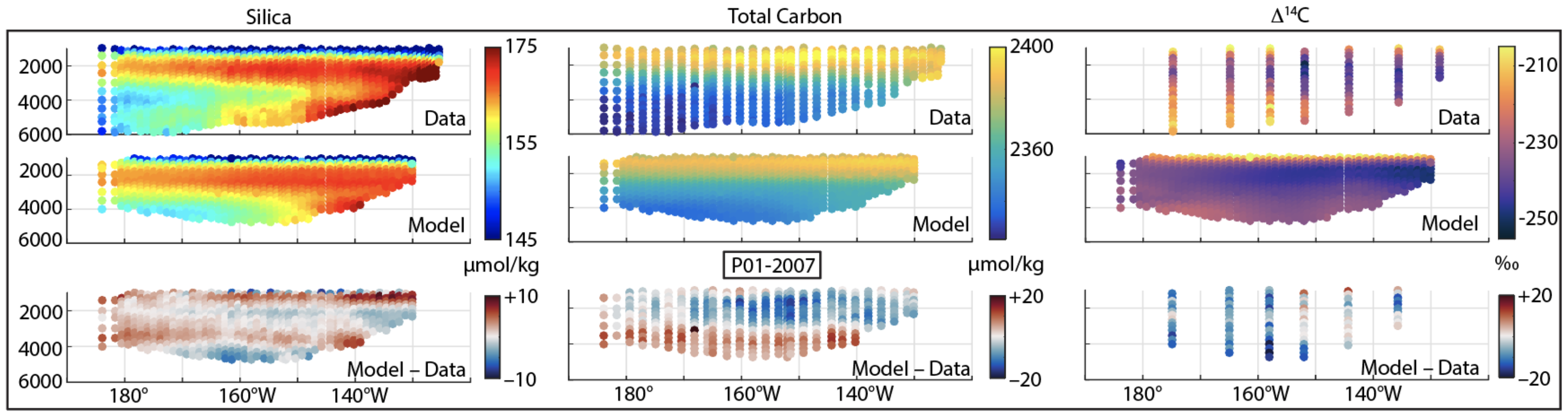
The causes of the double silica maximum have remained fuzzy for many years. We conclude that the structure arises from an eastern-intensified single-maximum in the North Pacific Deep Water along the northern domain boundary (originating in the western Pacific), and a strong subarctic bottom source supplying silica to Upper Circumpolar Deep Water density surfaces that successively intersect the seafloor over a broad area east of 150°W, associated geostrophically with southward flow. The existence of the double silica maximum is linked to the weak diapycnal transport in the deep interior, with broader implications for the conceptual picture of meridional overturning circulation in the North Pacific.
Publications
- Hautala, S. L. (2018). The circulation of deep and abyssal water in the Northeast Pacific Basin. Progress in Oceanography 160: 68-82.
- Hautala, S. L. and D. E. Hammond (2020). Abyssal pathways and the double silica maximum in the Northeast Pacific Basin. Geophys. Res. Lett. 47, e2020GL089010. https://doi.org/10.1029/2020GL089010
- AGU Ocean Sciences 2020 e-Lightning Talk
Funding: National Science Foundation