Surface Hydrology
In surface hydrology we focus on understanding the roles of climate, land use, and urban development in hydrologic response. Below examples from recent and ongoing projects are presented.
Ā Climate and Land Use Change in the Midwest
Long term positive trends in streamflow are widely reported across the Midwestern United States. During the period of observation from which these trends are derived the region experienced a changing climate as well as modification of the land surface through agricultural extensifcation. We explore these dominant influences on streamflow in the Upper Mississippi River Basin utilizing historical land cover and gridded climate data in hydrologic model simulations using the Variable Infiltration Capacity (VIC) model [Frans et al., 2013].
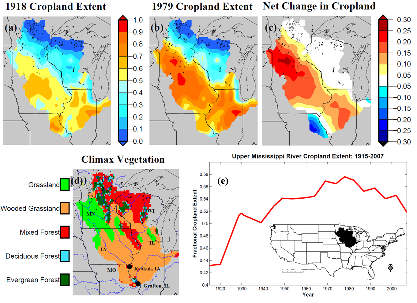
Model results suggest that at the basin scale vegetation change had no distinguishable influence on annual streamflow trends. However, at the local scale vegetation change decreased or increased annual runoff (8.7 and 5% respectively) depending on the initial vegetation present prior to conversion to cropland. Model simulations where drainage properties of the soil change through time in locations where tile drainage is estimated to be located are also conducted. Similarly, these results demonstrate that increasing artificial drainage through time can have a local impact (increasing mean annual runoff up to 15%) and no discernible influence on annual runoff at the outlet of the basin.
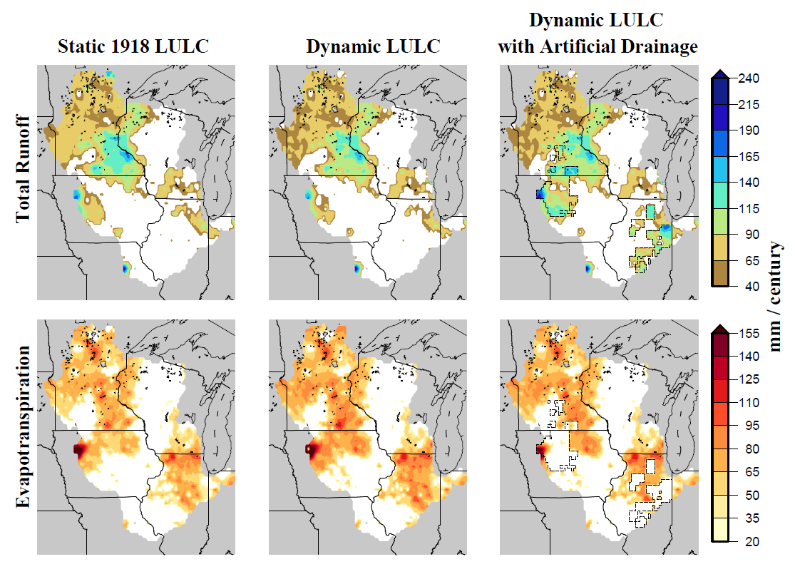
Representing changes in LULC through time, model simulations demonstrate that changes in climate are likely the dominant influence on positive regional streamflow trends. The importance of LULC on hydrologic processes of the land surface increases as the size of the drainage area decreases.
Ā Urban Ecohydrology Model
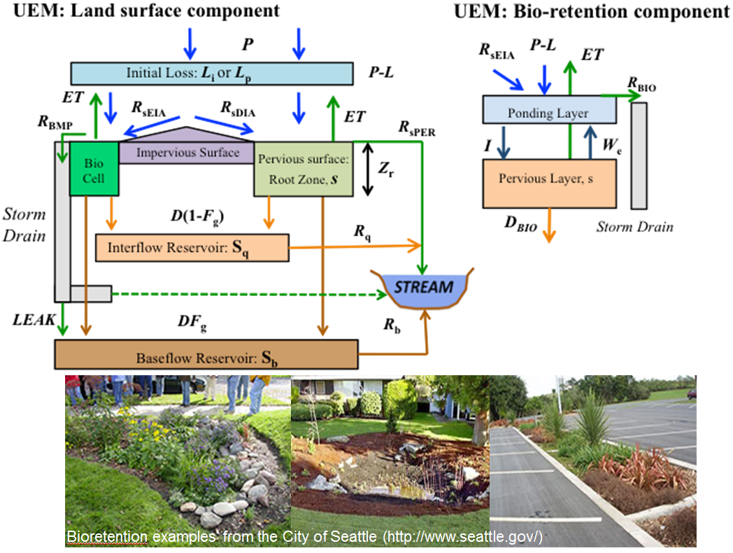
In collaboration with King county, WA we develop the Urban Ecohydrology Model (UEM) to estimate long term hydrologic behavior of urbanized basins. The model is a lumped representation of an urbanized landscape. The pervious surface layer is modeled by calculating depth averaged soil moisture in the root zone layer and biomass dynamics represented by live and dead biomass pools. The impervious surface layer represents the fraction of impervious surfaces in a catchment. The layer is further separated into effective impervious area directly connecting stormwater runoff to the storm drain, and disconnected impervious area directing stormwater runoff to pervious surfaces. Impervious surfaces alter the natural hydrology of an area by increasing the flashiness of stormwater generated runoff, resulting in increased storm peaks and volumes. We evaluate the effectiveness of low impact development for improving watershed health of urbanized catchments. Bioretention cells are modeled to intercept runoff from effective impervious area to increase storage and infiltration of stormwater runoff. This project was funded by EPA.
Conceptual Diagram of the UEM:
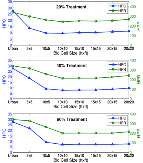
An example of a UEM run in a suburban catchment in Seattle. The figures plot High Pulse Count (HPC) and High Pulse Range (HPR) calculated from modeled hourly streamflow for different sizes of bio-retention cells. HPC and HPR are indicators used to assess the quality of stream habitats for salmon. A single bio-retention cell is designed to receive runoff from 1,000 ft2 of impervious area of the catchment.
70% of this catchment is impervious. The model is run to treat 20%, 40%, and 60% of this impervious area. The model suggests finite bio-retention cell size beyond which HPC and HPR stay constant.
Ā Hydrologic Modeling of Partially Glaciered Watersheds
Across the globe, many populated areas are located below glacierized terrain. Glacier melt water from these areas is often critical to sustain water availability throughout the year. The hydrologic behavior of these watersheds shifts under continuous climate driven glacier recession. Improving upon past modeling efforts in mountainous terrain, we use the Distributed Hydrology Soil Vegetation Model (DHSVM) with integrated glacier dynamics, simulating the coupled processes of glacier ice flow and hydrologic processes over long time scales. This modeling approach is applied to the glaciers of the Cordillera Real, serving water demands of La Paz, Bolivia, as well water resource infrastructure in the Pacific Northwest U.S., from irrigation infrastructure below Mount Hood, OR to a hydroelectric project in the North Cascades, WA, operated by Seattle City Light. This work is funded by NASA and Seattle City Light.
|