|
|
Wei Cheng, Ph.D.
Associate Professor and Chair of Computer Science and Systems Email: uwcheng [at] uw [dot] edu |
Biography
Wei received his Ph.D. from the George Washington University. His research interests span the areas of smart transportation systems, HCI, and edge computing. In particular, he is working on smart street infrastructure digitization, localization in GPS-denied environments, HCI, and public safety networks. His research have been funded by NSF, DOT, and NIST. He is the director of the PacTrans (Pacific Northwest Transportation Consortium, Regional University Transportation Center (UTC) for Federal Region 10) Tacoma subcenter. He served as the technical program committee chair/member and the editorial board member for several top international conferences and journals, respectively.
Research Interests
- Sign Language: AI for understanding sign language.
- Smart Transportation: AI for automatic street infrastructure digitization from standard dashcam imagery.
- Security: Utilize nano biometric sensors such as muscle sensors, eye trackers, and taste sensors for security and control applications.
- Emergent Acoustic
Communication: Acoustic
based solutions for localization and communication with mobile devices.
Student Recruitment
- Ph.D. Students: Students, who are interested in
pursuing their Ph.D. in the Tacoma School of Engineering and Technology or
the Department of Electrical & Computer Engineering at UW, please
email me your CV. Funding is available for U.S. citizens and permanent
residents, who will work in the area of cybersecurity.
- M.S. Students: Graduate students at UW
Tacoma are welcomed to contact me to conduct
thesis, capstone projects, or independent research.
- B.S. Students: I am recruiting students
for Undergraduate Research
Selected Products [My
Google Scholar]
Smart Street Parking and Infrastructure Maintenance
|
Application |
Features
& Key Findings |
|
Street Infrastructure Digitization and Maintenance Build Street Parking Map Street Parking Planning & Navigation Smart Car Autonomous Parking City Traffic and CO2 Reduction |
Automatically digitize street infrastructure from standard dashcam imagery Automatically read street parking sign
via cam Street parking circling navigation Street parking open spot detection Street parking rule data |
Automatically read street parking signs, symbols, and calculate the maximal
allowed parking time based on the time of arrival. The first two videos can be
played in 4K.
HCI & Sign Language [Open-Sign_Language ]
Application | Features & Key Findings |
Sign Language Translation | Comprehensive survey on datasets, resources, benchmarks, and Annotation Standard |
HCI & Security [Ref. 1]
|
Application |
Features
& Key Findings |
|
Device Control Security Service |
Nano EMG for finger movement detection Finger movement based control Finger movement based authentication Finger movement based key pairing |
Device Positioning
and Navigation in GPS-denied Environments [Ref. 1][Ref. 2][Ref. 3][Ref. 4][Ref. 5]
|
Application |
Features
& Key Findings |
|
Search & Rescue Indoor Navigation, Public Safety Networks Drone Swarm, Vehicle Swarm, Smartphone Underwater Networks, Space Exploration |
Smartphone based acoustic
communication Infrastructure free Quick autonomous organization and localization Theoretically proved the localizability
equivalence between centralized and distributed implementations. Theoretically proved the localizability
equivalence via altitude/depth awared projection 3-5cm fast phone-to-phone ranging accuracy |
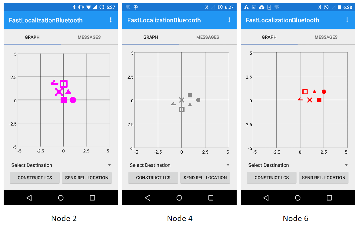
Each symbol represents a smartphone. There are six
phones. The picture shows each phone's view of the network.
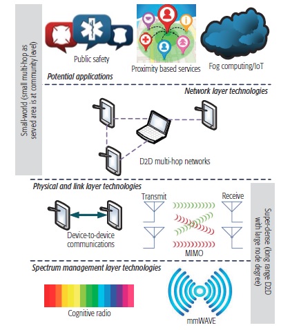
Fast Resilience Networking [Ref. 1][Ref. 2][Ref.
3]
|
Application |
Features
& Key Findings |
|
Smart Community, Public Safety Networks Super Dense Wireless Networks |
Unicast based route discovery Check the existence of multipath in a
small constant time Channel assignment complexity
analysis |
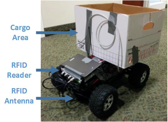
RFID based
Information Track [Ref.
1][Ref. 2][Ref. 3]
|
Application |
Features
& Key Findings |
|
Smart Transportation |
Resilience to weather and light
conditions Full unmanned vehicle support Lane level navigation Smart parking Security enhancement |
Grants
|
Sponsor: |
NSF DOT NIST |
Teaching Experience
|
Undergraduate: |
Computer Organization Computer Architecture Senior Project Design |
|
Graduate: |
Network Security Wireless and System Security Applied Distributed Computing |
Service Experience
|
School/Department: |
Chair Graduate Chair Undergraduate Committee Graduate Committee ABET Assessment Coordinator Faculty Search Committee (Chair) |
|
University: |
UWT Faculty Affairs Committee UWT Distinguished Research Award Committees Computer Literacy Seminar |
|
Synergistic Activities: |
EBM: IJCN, IJSNet TPC Chair: WASA 2018, WUWNet 2016
(vice), WTS 2014 Workshop Co-Chair: ICCCN 2015 Guest Editor: IoT Journal, WCMC, TNSE, JWCN, etc. TPC: INFOCOM, ICCVE, ICC, WUWNet,
etc. |
|
Last updated in April, 2026 |