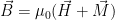
Demo setup, with yellow 72-wrap air-core coil connected to BK Precision 1730A power supply. Vernier current and magnetic field sensors are used to monitor experimental parameters.
My students and I are preparing to go up to Bellingham on Thursday to do some work in the paleomagnetic lab up there, so we spent today’s lab meeting getting everyone acquainted with the data they are going to collect. I started explaining something in the lab meeting that I thought could use a demonstration. So here it is.
Rocks might have lots of different magnetic particles in them. They might contain magnetite, an iron oxide that forms in igneous and metamorphic rocks as well as in soils; they might contain titanomagnetite, a common consitituent of oceanic basalt; they might contain maghemite that formed as magnetite was oxidized — rusted — by weathering, or they might contain maghemite that formed in soils; they might contain hematite or goethite, indicating soil formation in dryer or wetter environments… there are even rock-forming minerals like pyroxenes and micas that are magnetic to a certain extent. In addition to forming in different environmental conditions, all of these minerals have particular quirks in their record of Earth’s magnetic field. So we need to be able to tell the kinds of magnetic minerals apart.
One way we differentiate between magnetic minerals is by their response to weak magnetic fields. So I tried a little experiment. I put a bunch of different materials inside a wire coil. I could send a current through the coil, producing a (weak) magnetic field at the coil’s center. I also set up a magnetometer to measure the magnetic field just outside the coil.
Demo setup, with yellow 72-wrap air-core coil connected to BK Precision 1730A power supply. Vernier current and magnetic field sensors are used to monitor experimental parameters.
Why might the field inside the coil be different from what I measure with the magnetometer? This is a secret that is not addresed in the physics textbook we use in Physics II: there are two different ways of describing magnetic fields. We call the magnetic field that the magnetometer , and we measure it in Tesla. But there are two kinds of things that produce that magnetic field. One is the current through the coil, and the other is whatever is inside the coil (or outside it but close by). So we say that there is an applied magnetic field (applied by the coil to whatever is inside it) as well as a little bit of extra magnetic field due to whatever we put inside the coil. In physics terms, we call the applied magnetic field , and the bit of extra field from whatever is in the coil . Both of these are measured in A/m. We say that:
There are two ways you can get a little bit of extra field from putting stuff inside the coil. A large number of Earth materials become magnetic when you put them in a magnetic field, but then revert to what most people would call “non-magnetic” when the magnetic field is turned off. For example, if you put an iron-bearing garnet crystal inside an area with zero magnetic field, it wouldn’t attract a compass needle. But as soon as you turn the magnetic field on, the compass needle begins to deflect – ever so slightly – toward the garnet. We call that garnet paramagnetic. Other minerals, like quartz, are diamagnetic: put them in a magnetic field, and the compass needle deflects away from the mineral. For both paramagnetic and diamagnetic materials, the effect on the compass disappears when you shut off the magnetic field you’ve applied. We call this an induced magnetization.
Some materials also have a remanent magnetization – a magnetization that remains after the field is switched off. Magnetite is a good example of this. Besides behaving like an induced magnet, magnetite also has induced magnetic behavior.
So: I took pieces of a bunch of different materials – steel, teflon, hematite, and various other minerals – and put them in the middle of the coil to see what would happen to the magnetic field as I increased and decreased the current. I tried the mica in two different directions (with the edge pointed toward the magnetometer, and with the flat face 45° from the magnetometer) to see if there was an effect.
Materials tested in the air-core coil. From left to right: Nails, Teflon, optical calcite, tremolite, phlogopite (Mg-rich biotite), hematite, iron-rich dolomite.
Here is a plot illustrating the response of these materials to the magnetic fields produced in the coil:
The first thing you might notice is that all materials, more or less, make a linear trend on this plot. So the total magnetic field is proportional to the applied field. The biggest effect is in the bar magnets: they are ferromagnetic (the line of points does not intersect the origin, meaning that there is some magnetic field that remains when you turn off the field). The rest of the materials have a different slope, varying between low (Teflon) and high-ish (empty sample holder, keys, nail).
The ratio between applied magnetic field and a material’s (induced) magnetization is called magnetic susceptibility. It is given the symbols k, κ, or χ. If you were to measure magnetic susceptibility carefully, you could identify differences between these minerals – perhaps even between the different orientations of the mica. To do that, you need to have a good idea about what the response of your magnetometer would be if your coil were empty. That’s your model for how your measurement device works. It’s just a linear equation here: (using the variables we have here, ). You can then subtract your prediction based on the empty coil model from all of your magnetic field measurements to see whether the stuff you put in the coil is adding to (ferromagnetic, paramagnetic) or decreasing it.
Here is what you get when you subtract out the empty sample holder’s response:
On these graphs, a positive slope indicates a material that behaves as a paramagnet; a negative slope indicates a diamagnet. Most of these materials behave like a combination of the two – not a particularly steep positive slope (except for the bar magnets) and a variety of negative slopes. The Teflon rods have the steepest negative slope because they contain the most diamagnetic material. Because ferromagnetic materials retain a when the applied magnetic field is reduced to zero, their behavior shows up as a vertical offset of the whole graph, as seen in the bar magnets and in the hematite, below:
Here is the R code for the graphs:
library(ggplot2)
library(data.table)
library(plotly)

Sys.setenv("plotly_username"="paselkin")
Sys.setenv("plotly_api_key"="77arkum3zn")

D<-read.csv("h:/Dropbox/Personal/blog post/Selkin_MagProps_Demo.csv")
DT<-data.table(D)

materials<-c("Bar Magnets","Keys","Nail","Teflon Rods")
empty<-c("No Sample")
minerals<-setdiff(levels(DT[,unique(Item)]),union(empty,materials))

DT[Item%in%materials,ItemType:="Material"]
DT[Item%in%empty,ItemType:="Empty"]
DT[Item%in%minerals,ItemType:="Mineral"]

AP<-ggplot(data=DT,aes(x=Current..A.,y=Magnetic.Field..mT.))+geom_point(aes(color=Item))+facet_wrap(~ItemType)+scale_color_brewer(palette='RdBu')+xlab("Current (A)")+ylab("Total Magnetic Field (mT)")
MP<-ggplot(data=DT[ItemType=="Mineral"],aes(x=Current..A.,y=Magnetic.Field..mT.))+geom_point(aes(color=Item))+scale_color_brewer(palette='RdBu')+xlab("Current (A)")+ylab("Total Magnetic Field (mT)")
DP<-ggplot(data=DT[ItemType=="Empty"],aes(x=Current..A.,y=Magnetic.Field..mT.))+geom_point(aes(color=Item))+scale_color_brewer(palette='RdBu')+xlab("Current (A)")+ylab("Total Magnetic Field (mT)")+stat_smooth(method='lm',aes(color=Item,fill=Item))

models<-DT[,list(model=list(lm(Magnetic.Field..mT. ~ Current..A.))),by=list(Item)]
slopes<-models[, {coefs

ggplotly(AP)
plotly_POST(AP, "All Materials, Magnetic Susceptibility")

ggplotly(MP)
plotly_POST(MP, "Minerals, Magnetic Susceptibility")

ggplotly(MP+stat_smooth(method='lm',aes(color=Item,fill=Item))+scale_color_brewer(palette='RdBu'))
plotly_POST(MP+stat_smooth(method='lm',aes(color=Item,fill=Item))+scale_color_brewer(palette='RdBu'),"Minerals, Magnetic Susceptibility (With Trendlines)")

ggplotly(DP)
plotly_POST(DP, "Empty Holder")

DT[,Bcorr:=Magnetic.Field..mT.-((slopes[Item=="No Sample",coefs])*Current..A.)]
AP2<-ggplot(data=DT,aes(x=Current..A.,y=Bcorr))+geom_point(aes(color=Item))+facet_wrap(~ItemType)+scale_color_brewer(palette='RdBu')+xlab("Current (A)")+ylab("Extra Magnetic Field* (mT)")
MP2<-ggplot(data=DT[ItemType=="Mineral"],aes(x=Current..A.,y=Bcorr))+geom_point(aes(color=Item))+scale_color_brewer(palette='RdBu')+xlab("Current (A)")+ylab("Extra Magnetic Field* (mT)")

ggplotly(AP2)
plotly_POST(AP2, "All Materials, Corrected Magnetic Susceptibility")

ggplotly(MP2)
plotly_POST(MP2, "Minerals, Corrected Magnetic Susceptibility")

ggplotly(MP2+stat_smooth(method='lm',aes(color=Item,fill=Item))+scale_color_brewer(palette='RdBu'))
plotly_POST(MP2+stat_smooth(method='lm',aes(color=Item,fill=Item))+scale_color_brewer(palette='RdBu'),"Minerals, Corrected Magnetic Susceptibility (With Trendlines)")
This post summarizes a publication in the journal Nature (note paywall):
Biggin, A.J., Piispa, E.J., Pesonen, L.J., Holme, R., Paterson, G.A., Veikkolainen, T., and Tauxe, L., 2015, Palaeomagnetic field intensity variations suggest Mesoproterozoic inner-core nucleation: Nature, v. 526, no. 7572, p. 245–248, doi: 10.1038/nature15523.
Earlier this month, an article about the age of Earth’s inner core made a big splash on both traditional and social media. The early history of Earth’s core – and particularly the inner core – aren’t things that scientists understand particularly well. Nonetheless, the question of when the inner core formed is a part of bigger questions about how Earth got here and what makes it unique. We think that the inner core began to form once Earth had cooled a certain amount after its fiery infancy [1]. The inner core, then, is a sort of a thermometer for the early Earth: knowing exactly when the inner core started to form gives us some insight into just how hot Earth was shortly after its formation [2]. And I’m talking really hot here – magma oceans, not global warming. Other aspects of Earth that we consider more or less unique would have developed once Earth became cool enough. Plate tectonics and life are two examples.
Geochemists have fairly strong evidence from isotopes of the elements Hafnium and Tungsten that Earth’s metallic core must have formed in the first 50 million years of our planet’s history [3]. Earth has an unusually large core for a planet of its size. We think this is at least partially due to a Mars-size rock that plowed into the Earth early in the Solar System’s history. Computer simulations of this planetary collision indicate – and geochemistry confirms – that the event would have spun off some rocky material, becoming the Moon. The denser, metal-rich stuff left behind in the crash would have migrated toward the center of the developing Earth, forming our oversized core.
The origin of the inner core presents a bigger problem. Right now, we know about the inner core from the patterns of seismic waves that travel from one side of the Earth to the other, crossing different parts of the core. But seismic waves are ephemeral, dissipating soon after we record them. There are no seismic records from Earth’s past.
Earth’s magnetic field, generated in the fluid outer core (the geodynamo), might give us some clues about when the solid inner core formed. It takes some energy to generate Earth’s magnetic field. In the modern Earth, we think that the growing inner core powers the geodynamo: as the iron-nickel inner core crystallizes, light elements are spit out into the fluid outer core. The density difference between the sinking iron and nickel and the rising light elements, along with the temperature difference between the hot core and relatively cold mantle, cause the outer core to churn like a boiling pot of soup on the stove. This vigorous churning – thermal and compositional convection – produces a strong magnetic field relative to those of most other terrestrial planets. Without the inner core to drive the compositional part of the convection, the core would need to be very much hotter if we wanted it to produce a magnetic field like the one we have today.
Unlike seismic waves, we do have a record of magnetic fields from very old rocks. Since about the 1980s, geophysicists have been trying to identify patterns in the waxing and waning of Earth’s magnetic field over the billion-year timescales that we would need to look at planetary evolution. If we can identify a time when Earth’s strong and relatively stable magnetic field switched on, the reasoning goes, we might be able to tell when the inner core began powering the geodynamo.
I hedge my bets here about the magnetic field-inner core connection because of two main problems: first, it’s hard to measure the strength of Earth’s magnetic field in the past, and second, Earth’s magnetic field has varied through time due to a number of factors besides the inner core.
As far as the first problem goes, we have to make a lot of assumptions when using old rocks to look at Earth’s magnetic field. We assume that the rocks recorded Earth’s magnetic field reliably in the first place, through processes that we understand well. We assume that rocks are able to hold onto their magnetization for billions of years. We assume that the same rocks have not been remagnetized or demagnetized throughout their long histories. Although we have ways to test some of these assumption, our ability to do the tests depends on geological circumstance – whether the rocks contain certain dateable minerals, whether they have been folded or broken up and re-cemented together, or whether they are crosscut by more recent rocks, for instance. Even for young rocks, reading the strength of Earth’s magnetic field is much harder than looking at the direction of the ancient magnetic field (more on the specifics in a later post). Add to that the fact that rocks that have been around longer are generally more likely to have been re-magnetized, and you have a lot of reasons to doubt the paleomagnetic record of multi-billion-year-old rocks. For this reason, Andy Biggin and his co-authors on the recent Nature paper are choosy about which published data they use for their analysis [4]. Unfortunately, because of the problems mentioned here, and because there just aren’t many old rocks to choose from, reliable data on Earth’s magnetic field from the first four billion years of Earth’s history are few and far between. This is not the fault of the paper’s authors: reliable as the data may be, there are a lot of gaps. There are almost no useful data from the time interval between 300 million and one billion years ago. If you consider only the most reliable ancient field data from very old rocks – as Biggin et al. do – it is still difficult to draw a convincing long-term trend, since the estimates of Earth’s magnetic field strength vary widely for any particular range of ages. Nonetheless, in the set of data discussed in October’s Nature article, the average magnetic field estimate for the time period between 1.4 and 2.4 billion years ago is lower than that of the chunk of time between 0.5 and and 1.3 billion years ago. So perhaps we should be looking at rocks between 0.5 and 2.4 billion years old for other indications that the inner core formed. We also need to work at sorting out long-term trends from short-term variations for these very old rocks.
The second problem with the magnetic field-inner core connection is that Earth’s magnetic field is sensitive to things besides the growth of the inner core. For example, we think that the geographic pattern of hot and cold spots at the boundary between the mantle and the core might influence geodynamo activity [5]. We see this effect in both the intensity and in the reversals of Earth’s magnetic field. The hot and cold spots are related to convective motion in the mantle and perhaps to old, cold chunks of tectonic plates that have sunk over hundreds of millions of years. This would mean that the strength of Earth’s magnetic field may change on the few-hundred-million-year time scales associated with plate tectonics. Biggin et al. average data over long time periods to get rid of these fluctuations – akin to averaging weather variations to look at climate – but they acknowledge that especially long-lived patterns of heating and cooling may influence their averages. The further we look back in time, the fewer assumptions we can make about plate tectonic activity and its consequences. A electrically conductive molten layer of rock that may have blanketed the core early in Earth history (a “deep magma ocean”) could also have affected the early geodynamo [6]. More importantly, although geophysicists have made incredible strides over the past decade simulating core behavior, it’s not entirely clear how the average intensity of the magnetic field is related to the power driving the geodynamo. My impression (as a non-modeler) is that modelers agree that if the power available to move stuff around in the outer core drops below a certain lower limit, the geodynamo would shut off. But does more power necessarily mean a stronger field? The intensity of Earth’s field is not the only indicator of geodynamo activity. We might seek clues from other aspects of Earth’s magnetic field, such as how often the North and South magnetic poles switch, the rate at which the poles move, or the degree to which Earth’s field is similar to that of a bar magnet (Biggin et al. do explore the latter issue to a certain extent).
All of this is to say that, while the Nature article represents the best of our knowledge right now, there’s still a log way to go before we can conclusively say when the inner core formed. We are much closer than we were when I was a graduate student (when I graduated in 2003, only about 36% of the studies used in this paper had been published [7]). This is an exciting time to be a paleomagnetist!
[1] Rubie, D.C., Nimmo, F., and Melosh, H.J., 2007, Formation of Earth’s Core, in Treatise on Geophysics, Elsevier, p. 51–90.
[2] The Earth may have got rid of some of its initial thermal energy before the core formed.
Stevenson, D.J., 2007, Earth Formation and Evolution, in Treatise on Geophysics, Elsevier, p. 1–11.
[3] Basically, radioactive Hafnium-182 preferentially goes into molten metals, whereas its decay product, Tungsten-182, stays in rocks. Comparison between Tungsten-182 concentrations in meteorites and the Earth indicates that the radioactive Hafnium-182 must have separated from the mantle about 50 million years after Earth initially formed.
Lee, D.-C., and Halliday, A.N., 1995, Hafnium–tungsten chronometry and the timing of terrestrial core formation: Nature, v. 378, no. 6559, p. 771–774, doi: 10.1038/378771a0.
Rubie, D.C., Nimmo, F., and Melosh, H.J., 2007, Formation of Earth’s Core, in Treatise on Geophysics, Elsevier, p. 51–90.
[4] The Nature paper that I’m discussing here is a meta-anlaysis, meaning that it analyzes data collected in many studies to draw a broad conclusion. The authors rate estimates of magnetic field strength from 53 studies on a scale (QPI) according to how many assumptions have been verified in the experiment and field work of the original study. Most studies published these days get about a 3 out of 6 on the QPI scale. More about the types of experiments – called paleointensity experiments – in a future post.
[5] Although there has been more recent work on this topic, here’s the original reference:
Glatzmaier, G.A., Coe, R.S., Hongre, L., and Roberts, P.H., 1999, The role of the Earth’s mantle in controlling the frequency of geomagnetic reversals: Nature, v. 401, no. 6756, p. 885–890, doi: 10.1038/44776.
[6] Ziegler, L.B., and Stegman, D.R., 2013, Implications of a long-lived basal magma ocean in generating Earth’s ancient magnetic field: Geochemistry, Geophysics, Geosystems, v. 14, no. 11, p. 4735–4742, doi: 10.1002/2013GC005001.
[7] Just for my own interest, I plotted up the number of studies and the number of magnetic field intensity estimates from the dataset that Biggin and co-authors use. The graph shows how many of these studies (and field estimates) of different quality indices have been published each year. There’s a definite shift from publishing papers with few assumptions justified (QPI 1 or 2) to those with more checks (QPI 3 or above)! I do wonder how many more rock units are available for study – sounds like a useful GIS project!
Composition of Biggin et al. dataset by QPI and publication year. The graph on the left counts the fraction of studies included in the Biggin et al. dataset; the graph on the right counts the fraction of paleointensity estimates. The year of my Ph.D thesis (2003) is indicated in red for comparison with today (2015). Note the large fraction of the QPI 5 and 6 studies and estimates published since 2003. Note that Biggin et al. average paleointensity estimates to counteract the over-representation of certain studies with large numbers of paleointensity estimates in the database.
The "Jeep" from my undergrad research days. Photo by Steve Dornbos.
The “Jeep” from my undergrad research days. Photo by Steve Dornbos.
Almost 20 years ago, I was lucky enough to be a student participant in two undergraduate research programs – the Keck geology consortium and Caltech’s SURF program (full disclosure: I didn’t participate in all aspects of the SURF program). The Keck program in particular involved a summer spent mapping and studying gabbro [1] on the island of Cyprus – a fragment of old ocean crust. That project introduced me to independent fieldwork, paleomagnetism, study design in geology, and a large network of friends and mentors. Some members of that network would later become collaborators and my Ph.D. advisors. Many of my friends became geoscientists.
If you are an undergraduate science student and have the chance to do a research project, I can’t stress how important it is to take that opportunity. Whether or not you end up in science, you develop experience, skills, and personal connections that will help you later in life. If nothing else, you get to find out if a particular area of science is right for you. While this experience is associated with a bit of a sacrifice – particularly for many of my students who have family and/or work obligations during the summer – there are some programs that will work with you to make it easier. Some offer a stipend, and others might be located near where you live or work and have flexible hours.
How do you find a good program? Here are some national programs in geoscience and environmental science that I recommend. If you’re going with a different one, I recommend talking to the faculty members involved to get a feel for how they mentor their students, how many students are involved, and what they think you’d get from the program. Also talk to former students if you can.
GeoCorps: Paid internship opportunities to do geoscience in the National Parks and other federal sites. Requirements and application dates vary.
The Summer of Applied Geophysics Experience through Los Alamos National Labs in New Mexico. A fantastic hands-on experience in environmental geophysics in the field. Requires a year of physics and calculus. Application date unknown.
The Keck Consortium is still around! Although it’s run by faculty from liberal arts colleges, students from elsewhere have applied. However, outside applications are not an option for the upcoming cycle due to budget cuts. Requirements depend on the project. Application date unknown.
The UNAVCO Research Experiences in Solid Earth Sciences for Students: learn about GPS, LIDAR, and other geodetic (earth-measurement) techniques in the field. Requirements include “some” physics, math, and geoscience, but are not very strict, as far as I can tell. Application opens November 16, 2015.
Undergraduate Studies in Earthquake Information Technology through the Southern California Earthquake Center and the University of Southern California. This program is unique because it focuses not just on seismology, but on earthquake hazard communication, and on forming interdisciplinary teams to build ways (often online) to communicate earthquake hazard effectively. Application dates and requirements unknown.
Please let me know about other opportunities in the comments. I’ll try to keep this list up to date when I find out more information about the programs above!
I wrote an assignment for my students yesterday. I ask them to write a blog post (watch for those soon), and give them some guidelines for doing so. I thought it was worth putting up here both for public comment and because I think it’s a nice statement about what I’m trying to do here.
I highly recommend that everyone who goes through my lab learn how to explain their project to the public. This is partially because you’ll have to do it when you get to Senior Seminar (TESC 410). Evan more importantly, it’s because we scientists need to be better about engaging the public with our science. If we don’t, we run the risk of becoming the kind of caricature of a scientist you see in the movies: academics with no connection to the real world.
So, to make that connection with the public, we have a blog. Or rather, I do, since I’m the one who usually writes for it. I try to explain what’s exciting about my science in a way that college students taking an intro class (or any interested people at about that level) might understand. The audience I write for isn’t stupid, but they might not be familiar with the jargon we use as scientists and the kinds of graphs we show each other. They might not care about the details of my work, but they do care about what’s new, exciting, or potentially relevant. Why I do things is much more relevant than how I do them. My audience also cares about stories (I think), including stories about how science works for me.
There are no strict rules about writing a blog post. This is an assignment with no strict page limit or style guidelines. Really, it’s the ideas and how you convey them that matters. I’ve seen a lot of good material on how to run a blog in general. I’m collecting it below. Some of it might be helpful if you’re writing a single post. In the broader sense of communicating your science, I’ve found some useful guidelines in Nancy Baron‘s book Escaping the Ivory Tower. Baron directs an influential program called COMPASS that focuses on preparing scientists to better communicate with the public. Her book has a lot of useful information about how to make sure your science is relevant to different audiences (politicians, journalists, filmmakers, etc.).
One of COMPASS’s signature tools is the Message Box, a scheme for organizing your scientific ideas so you can pitch them to non-scientist readers. Working your ideas into a message box is hard. But it’s good preparation for writing a blog post. Plus it forces you to think about how your science s relevant… which is the whole purpose of doing it! If you want to give the message box a try, there is a template here.
Guidelines:
Aim for about a page of text, with an image. If you don’t have an image, I can help.
You can use informal language, but don’t be sloppy. People will read this.
Have you taken pictures? Drawn comics? Found places on Google Maps? Great! I’m a visual person, and I like having good images on the blog.
Aim to engage people rather than to explain. Stories are good.
Avoid jargon, but don’t dumb it down. Explain it when you have to. I think of my posts as initiating readers into the club of people who understand what I’m talking about.
Look at other blog posts for inspiration.
Some of the cores here are from the early days of deep-sea drilling, when the GLOMAR Challenger was the drill ship. These Deep Sea Drilling Project (DSDP) cores used to be in San Diego when I was in grad school, but were moved here a decade or so ago.
While at Texas A&M University for our postcruise editorial meeting [1] with some old friends from the Bengal Fan expedition, I took the opportunity to visit IODP’s Gulf Core Repository.
Some of the cores here are from the early days of deep-sea drilling, when the GLOMAR Challenger was the drill ship. These Deep Sea Drilling Project (DSDP) cores used to be in San Diego when I was in grad school, but were moved here a decade or so ago.Scientists can come here and sample cores (you need to submit a sample request and have that request approved first), or you can have IODP staff collect samples and send them to you (again, sample request required).Cores are kept in refrigerated rooms to keep them from drying out.An x-ray fluorescence (XRF) scanner, which allows scientists to measure variations in the chemistry of rocks or sediments within a core. You put the core in the machine, and zzzzzzzzzip! in a little while you get hundreds of measurements of chemical composition, all along the core’s length. It’s not as accurate as other methods for geochemical analysis, but it allows us to measure a lot of material quickly.Here’s a surprise: not all of the cores at the repository are marine! This is a core from the San Andreas Fault Observatory at Depth (SAFOD), a deep borehole through the San Andreas Fault that was later fitted with instruments to measure deformation and seismic activity. This is the section that cored through the main San Andreas Fault itself, Hannah thinks.A core through some corals.Gabbro – part of the lower ocean crust. I believe this is from Ocean Drilling Program Leg 206.Here is the Cretaceous-Paleogene boundary (K-Pg, or “K-T” in the old nomenclature), where the dinosaurs – as well as countless marine creatures – went extinct. I’m not sure which core this is from, but the dark deposit is found in just about all K-Pg marine sediments.Here’s Hannah with the K-Pg boundary core, so you can get an idea how small the dark layer is.Drilling doesn’t always go so well: here’s a drill pipe that had to be blown up with TNT because it was stuck in the seafloor! Fortunately, we never had to do this.A cutaway view of the coring assembly, including the bit with rotary cones and fluid vents, the core catcher, and an advanced piston core (APC) cutting shoe.
[1] Although we spent many hours writing and editing our reports on the ship, we were under a lot of time pressure on the cruise. Fast writing isn’t necessarily good writing. So, typically, a subset of the scientists from a drilling expedition gets together after the expedition to edit the reports. We had the benefit of shorter shifts (not 12 hours! Yay!), good communication with the outside world, fast internet access, and an publications staff including editors and illustrators. Soon after we’re done, we should have a document that looks like this example from a previous expedition. It won’t be published for a year due to the post-cruise moratorium – we get a year’s head start on publications from our work – but you can read a summary here.
The editing session is also a bit of a reunion. It was great seeing friends from the ship again!
In my drive to get everything in the lab automated, I’ve set up a checkout system for the lab books. To check books in or out, use this form, or scan with your phone. Note that on the mobile app, you will have to type in your UW NETID, whereas on the browser form you will need to log in.
If you are a UW Tacoma student who uses Zotero as a reference manager (as I suggest my students do), you can now output a bibliography in the modified CSE format that we use in our science courses at UW Tacoma. The hallmarks of the modified CSE format are:
It’s based on the standard Council of Science Editors Author-Year format, available for Zotero here.
Electronic articles and e-books are cited as if they are in print, avoiding the clumsy URL and access information that is useless outside the UW campus.
So, for example, here is a bibliographic entry in the standard CSE format:
Hodges KV. 2000. Tectonics of the Himalaya and southern Tibet from two perspectives. Geological Society of America Bulletin 112:324–350. [accessed 2015 Apr 14] http://gsabulletin.gsapubs.org/content/112/3/324.full
Note that the link won’t work unless you have access to Geological Socienty of America publications, which most students don’t at home. The link gets even more convoluted when you are trying to find an article through EBSCOHost or another repository that stores the articles behind a paywall. I see this all the time in student papers. So instead, using this format, you can reference the article as if you had it in print:
Hodges KV. 2000. Tectonics of the Himalaya and southern Tibet from two perspectives. Geological Society of America Bulletin 112:324–350.
Easier, huh?
Here is how to download the file to the Zotero Standalone application:
Last quarter, I introduced some programming (in Glowscript) into my intro physics course. At the end of the quarter, I got evaluations from a number of students who said something like, “I’m not a computer science major. Why do I need to learn to program?” Besides being a marketable job skill, learning to program gives you a completely new way to solve problems in the physical sciences. Computer models are also a standard tool in every scientific discipline I’ve encountered, so if you are going to major in the sciences, you need to learn how they work.
Getting started in programming is easier now than it ever has been in my memory. There are a ton of resources online. You don’t even need to install software on your computer to get started (though I’d recommend you do). What follows are some recommendations for students in my lab, but they go from general to specific, so if you are not a paleomagnetist/geophysicist, you can read until you feel like stopping.
Before you start, consider what programming language to learn. I recommend that my research students learn Python for the following reasons:
It’s available for free.
Even if you want nice add-ins and an easy-to-use editor, it’s still free for academic users.
It’s what ESRI uses for a scripting language in ArcGIS, so if you do our GIS certificate program, you’ll use it.
Programming in Python is relatively straightforward and forgiving.
There are tons of add-in packages for all sorts of scientific purposes: if you don’t know how to write a complex piece of code, chances are someone has already done it for you.
There are ways to interface with all sorts of nice graphics packages like plotly and other software packages like R.
You can document what you do in notebooks, which you can share with the lab.
For paleomagnetists: Lisa Tauxe’s PMAGPY software is written in Python.
There are a few other languages you’ll want to learn for specialized purposes:
R, for statistics. We use it in our environmental stats course. It’s also free, has lots of add-ins, and is in wide use in academia and industry.
Mathematica, for specialized tasks (mainly IRM acquisition modeling). I don’t know this one all that well!
Matlab, for linear algebra. I don’t use Matlab so much anymore, since I can do most of the same things with Python or R… which are free. However, Matlab is widely used in geophysics.
What do you need to get started in Python? Although Mac computers come with Python installed already, I’d recommend installing Enthought’s Canopy software under an academic license. That gives you not only Python and the Matplotlib graphics add-on, but a nice way to keep track of and edit your programs or notebooks. It’s free for students and faculty, though you do need to register with Enthought. Otherwise, it’s a bit of a headache to try to install (if you are using a PC) and/or update Python, Matplotlib, and all of the other required stuff individually.
There are lots of resources available to help you learn Python. A list of the major ones is here. For the basics – if you are still just testing it out and haven’t installed anything yet – I like http://www.learnpython.org/ because it allows you to try things out in your browser window. However, learnpython.org does not teach you to use the Canopy software. A Canopy academic license allows you to use the Enthought Training on Demand tutorials. The Intro to Python tutorial looks really good. Has anyone tried it? Let me know how it is! Also, Lisa Tauxe’s PMAGPY Cookbook has some notes on using Python.
As a scientist, you will also want to get familiar with the NumPy, SciPy, and Matplotlib/Pylab packages (a package is the Python term for an add-in). Tutorials for these are available at python-guide, through Enthought, and in the PMAGPY Cookbook. There’s also a cool gallery of examples for Matplotlib.
The classic Numerical Recipes by Press et al. has lots of explanations of how to do common statistical and mathematical tasks in computer code. I don’t know if there’s a Python version out now (I have an old edition for the C language), but it’s a useful place to start for scientific programming. I’ve also found the book Programming Pearls by Jon Bentley useful for some things.
Now, for the specialized paleomagnetics stuff: download and install Lisa Tauxe’s PMAGPY package. This provides you with a set of programs that you can use to plot, manipulate, analyze, and model paleomagnetic data. Most have graphical user interfaces, and Tauxe has a good set of tutorials in the PMAGPY Cookbook. But it also provides a set of functions (pieces of code for performing specific tasks) that you can use in your own programs for common plotting and data analysis tasks.
Have you ever been curious how geoscientists know what’s under their feet? In Environmental Field Geophysics (TESC 419), you will learn to use seismic, magnetic, and gravity surveys to investigate the shallow subsurface environment. The course is a project-based introduction to practical geophysical tools and data analysis, along with some of the physics that makes those tools work. The 7-credit field course, scheduled for this coming Autumn quarter (2015), meets Fridays and has local field trips. It counts as a field course for the geoscience degree option. Physical geology with lab and one quarter of introductory physics are prerequisites. Please contact Peter Selkin (paselkin@uw.edu) soon for an add code.