The variable displayed in all the figures is the difference between the observation of S or T nearest the surface and the next deeper measurement. In the case of the TAO moorings, measurements were taken variously at 1, 3, 5 and 10m depth. For the CTD figures, differences shown here were taken between samples at 1m and 5m, and all EPIC CTD profiles within 153°E-166°E, 6°S-6°N (867 profiles) were used for comparison with the TAO moorings. A description of the two types of plots used (distribution functions and probability density functions) is given in each plot group heading below.
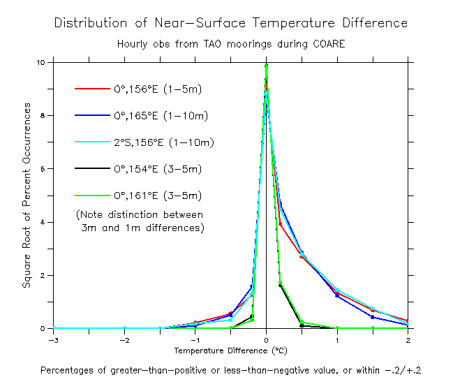
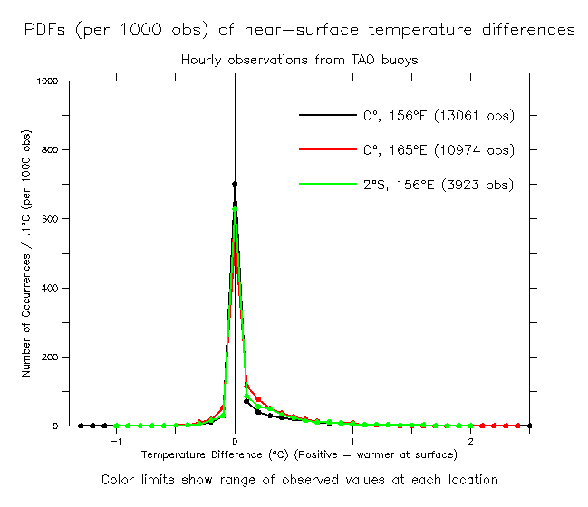
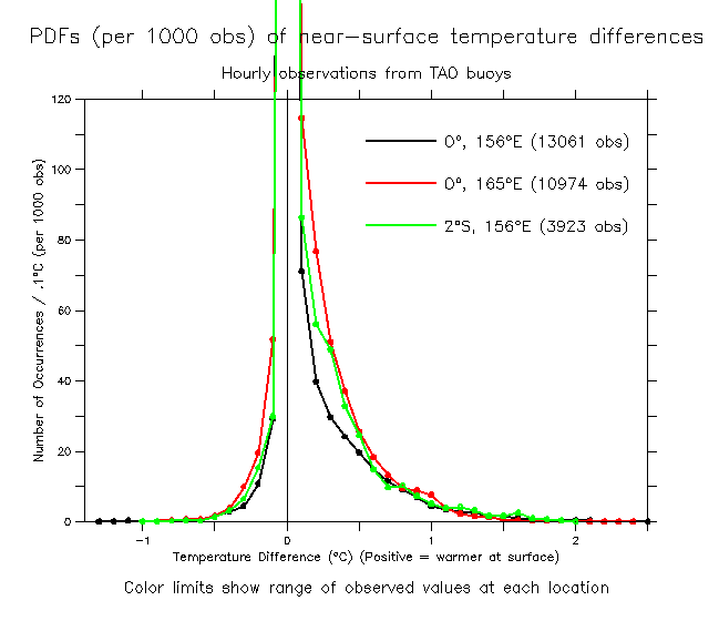
Results. Figures 2 and 4 show that the three moorings with 1m sensors (0°,156°E, 0°,165°E, 2°S,156°E) all have similar distributions of differences, distinctly different from moorings with the top sensor at 3m (0°,154°E and 0°,161°E), both for temperature and salinity. Almost all the 1 to 10m difference occurred between the 1 and 3m sensors, and therefore: 1) little information for the present purpose was gleaned from buoys with the top sensor at 3m; 2) little difference was found between moorings with 1 and 5m sensors compared to those that only had 1m and 10m sensors. This was true for both T (Fig. 2) and S (Fig. 4).
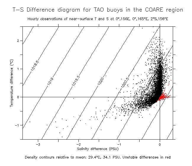
Distribution functions for near-surface differences in the western equatorial Pacific tend to be skewed, with T and S warmer and fresher at the surface. Fig. 1 shows all the TAO differences studied here (27,958 total hours of observation at 3 moorings with 1m sensors). Cases with near-surface gradients fall roughly into two classes: warmer with nearly constant salinity or cooler and fresher at the surface. Most of the differences indicated vertical stability, although this varied among the three moorings studied, with 60% stable at 0°,156°E, 76% stable at 0°,165°E and 98% stable at 2°S,156°E. The reasons for the difference among mooring locations is not known.
About 80% of all temperature differences measured on the moorings had magnitude less than 0.2°C (Fig. 2). About 8% of the TAO T observations were more than 0.5°C warmer at the surface than just below, 1.5-2% were more than 1°C warmer, and less than 0.5% were more than 1.5°C warmer. Of a total of 28,000 hours of observation, only 12 hours had near-surface T difference more than 2°C, with the maximum recorded difference being 2.49°C. A few of the differences had cooler surface T (associated with cool fresh pools following heavy rainfall(?)). About 0.3% of the TAO profiles had T cooler by more than 0.5°C, while 8 hours out of 28,000 were more than 1°C cooler.
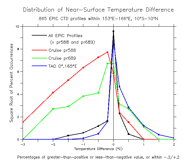
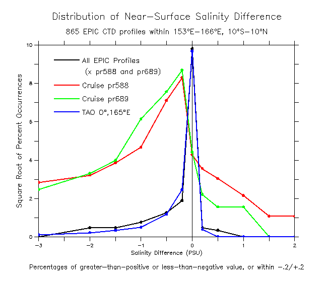
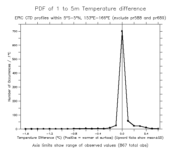
Temperature difference patterns for the 867 EPIC CTD profiles in this region (Fig. 3) were fairly similar (the CTD figures show a representative TAO curve overlaid; compare the black and blue lines in Fig. 3), except these T differences were relatively less skewed (a larger percentage were cooler at the surface and smaller percentage were warmer) (Fig. 3). About 0.35% of all the EPIC CTDs in the region had T cooler by more than 1°C. The CTD figures also show distributions for two cruises (pr588 and pr689, overlaid in Figs. 3 and 5) with many apparently questionable differences, very much cooler (also fresher, see below) at the surface than just below.
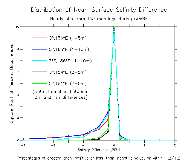
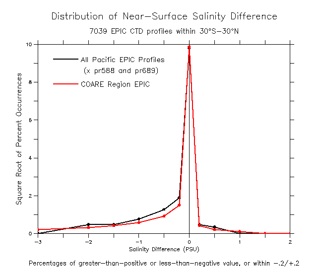
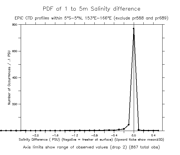
Fig. 4 shows that about 94% of the salinity differences had magnitude less than 0.2 PSU. About 5% of the TAO salinity differences were fresher than 0.2 PSU, 1.2% fresher than 0.5 PSU, 0.2% fresher than 1 PSU, and 28 out of the 28,000 were fresher than 1.5 PSU. The largest difference was 3.38 PSU. The CTD differences (Fig. 5) were quite similar to those found from the TAO moorings. The largest 1m to 5m difference was 2.32 PSU. As was the case for temperature, the two cruises pr588 and pr689 were distinctly different from the others, with many very fresh observations (about 15% fresher than 1.5 PSU with maximum differences greater than 5 PSU). These two cruises also had 2-4% of salinity differences more saline by more than 1 PSU. Fig. 6 shows that the COARE region distribution of near-surface salinity differences was typical of the entire EPIC data set over 30°S-30°N.
The bottom line. Therefore, it is concluded that near-surface differences warmer than 2°C, cooler than -1°C, fresher than -2 PSU, or saltier than 0.2 PSU are extraordinary (occurring approximately once in 1000 profiles in this region) and are to be regarded with suspicion. In particular, for cruises pr588 and pr689, 20-40% of all the profiles had differences greater than these standards and apparently represent some failure of data collection in this regard.
(See also the PDF page for more (lots more) detailed PDFs)