Designing APM Circulator Systems for Major Activity Centers: An Interactive Graphic Approach
by
Jerry B. Schneider
(This paper was published originally in the Proceedings of Automated People Movers IV: Enhancing Values in Major Activity Centers, American Society of Civil Engineers, New York, NY, 1993, pp 535-545, edited by W.J. Sproule, E.S. Neumann and M.V.A. Bondada. An updated version is made available here with the permission of ASCE. Any other use must also obtain the copyright permission held by the ASCE.)
Abstract
An interactive graphic computer program, called C-CAD , is used to design an APM circulator system for a large and complex major activity center. The design process is intuitively guided and makes use of several graphic displays of the spatial performance of alternative designs. A design/redesign process is illustrated that shows how performance improvements can be obtained by generating and evaluating a series of successively better design solutions.
Introduction
The purpose of this paper is describe a method for designing a one-way route layout for an APM circulator system located within a major activity center (MAC) in a large metropolitan area. It is assumed that a high speed ground transportation system (rail or maglev) station is located in the MAC and the objective is to serve both internal trips and trips to/from this high speed system station. The basic concept involved is to provide an easy and fast way to get to/from a station without using an auto or bus so as to reduce congestion and delay, air pollution and parking problems within and around such stations (Ettenger, 1989; Kulash, 1989; Schneider, 1992a, 1992b, 1992c). In addition, such a circulator could serve many other mobility needs within the MAC. It can provide good accessibility to nearby office, retail, institutional and residential areas as well as dispersed parking lots in areas where they are acceptable to the community. It is likely that this dual purpose circulator has a reasonable chance to be economically feasible (Schneider, 1992d).
There are many ways that a people-mover circulator system could be laid out to serve such an area (Schneider, 1992b, 1992c, 1992d). Typically, a planner should generate and evaluate several possible sketch-level designs (layouts) early in the planning process. These results can be used to assess the feasibility of the circulator concept in a particular setting before more detailed and costly travel demand, engineering and other studies are undertaken. In this paper, we show how alternative sketch-level designs can be devised with an interactive graphic computing system, using a hypothetical but realistic illustrative example.
APMs are generally quite expensive to build and cannot be justified easily in relatively low density American cities. MACs that currently have a badly congested street system, very poor air quality and impossible pedestrian circulation opportunities are good candidates for an APM circulator. These problems (for areas called Edge Cities) are well-documented in a recent book (Garreau, 1991) and in a research report (Cervero, 1988). Landowners in such MACs often cannot obtain permits for new development because of these problems. And, their suitability as a location for a new intermodal station for urban and/or high speed intercity trains (rail or maglev) may not be good for the same reasons.
An ideal circulator system would provide non-stop service during most hours of the day, be reasonably fast (2-3 times faster than an auto or bus on congested streets with signalized intersections), have very short waiting times (less than a minute), be environmentally benign (quiet, non-polluting, visually appealing), safe and secure, reliable, convenient, easy to build (without significant construction time and disruption) and reasonably inexpensive to construct, use and maintain. These are demanding requirements that can be met by few existing APM technologies today. Nonetheless, they are believed to be within reach sometime during the 1990's (Anderson, 1988, Technical Committee, 1988).
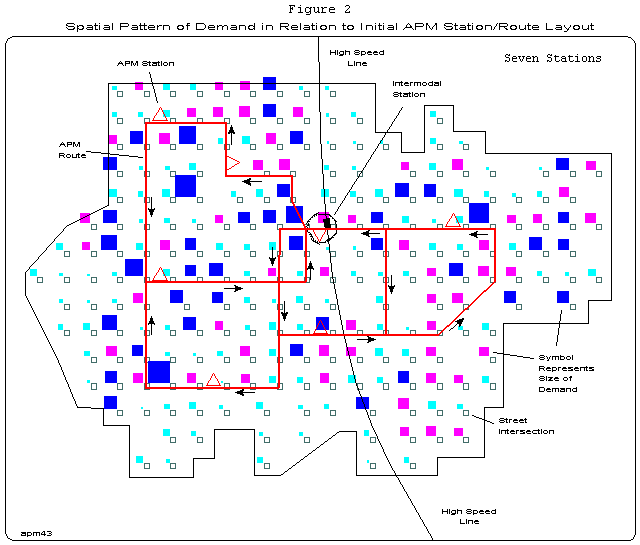
An illustrative example is used to show how a high performance system can be designed. The hypothetical but realistic major activity center used for this purpose is described in Figure 1 . This MAC is typical of one that might be located either in a central city or a suburb of a large metropolitan area. We will assume that it is served by a high speed system route which has a stop at an intermodal station located near the center of the MAC. A street network is shown as is the spatial pattern of demand for travel within the MAC. Each square symbol represents the location of a specific number of people who wish to travel to some other location within the MAC during a particular period of time.
The size of the squares indicates the number of people at each location (i.e. their origin location) who wish to use the circulator system. The origins of a total of 11,259 persons are shown in Figure 1 . The destinations desired by these people are not visible but it is assumed that all of them want to use the circulator system to get to the intermodal station and other destinations within the MAC.
Figure 1 also shows 38 locations that have been found to be feasible sites for an APM station. Each of these locations is a candidate because it has passed some feasibility and public acceptance tests early in the planning process. Our design problem involves selecting a few of these locations, linking them together with APM guideway segments and then evaluating the performance of the resulting system. This is done with the aid of an interactive graphic computing system that allows the planner to generate and evaluate a series of design options quickly and easily.
Conduct of the Intuitively-Guided Design Process
Figure 1 provides a useful starting point for the APM station location and route planning process. The problem is to select a limited number of stations and connect them with one-way routes so as to provide the best possible level of circulator service to the people in the MAC. In this example, one-way routes are used so as to avoid complex interchange structures where the routes cross.
The overall goal is to maximize the benefits provided while minimizing the capital cost requirements. This will be done by trying to maximize the level of service provided while minimizing the number of stations and the length of guideway used. Also, the routing should be laid out so that all persons in the MAC have comparable levels of service -- to the extent possible. It is assumed that our clients have determined that their specific objectives for this problem are to design an APM system that (1) places at least 90 percent of the demand within 15 minutes of the intermodal station and (2) allows a person at any APM station to travel to any other APM station in the system in 15 minutes or less.
To illustrate how an intuitively-guided design process can be conducted, we begin with the intuitively-derived design for the APM circulator system, shown in Figure 2 . It is called the initial design and will serve as a starting point for an iterative design process. Its routes and stations have been selected intuitively so as to match (visually) the spatial pattern of demand reasonably well while providing service to all parts of the MAC. It has 7 off-line stations, one of which is an integral part of the high speed system station near the center of the MAC. All of the routes in this initial design are one-way routes as shown by the directional arrows in Figure 2 . The total length of the mainline guideway in this design is 8.87 miles (14.28 km). All of the stations are off-line and the off-line guideway needed to serve them is 1.4 miles (2.25 km) in length. The total length of the guideway is 10.24 miles (16.48 km).
This network layout has just one overpass near the center of the MAC and all other junctions are same-elevation merges. This initial design provides service to an area of about 4.4 square miles whose main dimensions are shown in Figure 1 . A MAC of this size located in a suburban area would typically contain 15-40,000 jobs and several thousand residents. The street system has grid form with streets about one-eighth of a mile (0.2 km) apart.
It is assumed that the APM system can provide mainline speeds of 30 mph (48.3 kph) and that the average speed on the off-line guideway is 10 mph (10.6 kph). All other movement takes place by walking at a speed of 3 mph (4.8 kph). All of the trips that we consider in this example involve walking to an APM station, riding the APM to another station and then walking to the destination. A transfer time of two minutes has been assumed to be needed at both the intermodal and the APM stations to transfer from one mode to another.
Trips that involve the use of an auto are certainly possible (and are currently very frequent) within a MAC but we wish to design a circulator that will not require the use of an auto for any portion of the trip. However, we assume that some of our demand numbers represent persons who drive to the MAC from elsewhere in the region, park their auto and then walk to an APM station for a trip to some other location within the MAC.
Given this initial design, the planner can use a computer program, called C-CAD, to evaluate its likely performance. C-CAD can be used to design and evaluate the performance of any type of technology that one wishes to use for their circulation system. It uses a coded representation of the street network and the APM network together with data that represent the location and size of the demand to compute a set of performance measures for a given design. It provides a wide variety of printed tables and graphic displays to help the planner evaluate a design and compare it with other designs. A detailed description of the functions and capabilities of the C-CAD program cannot be given here but they are described in detail in a User's Guide (Xiong and Schneider, 1991).
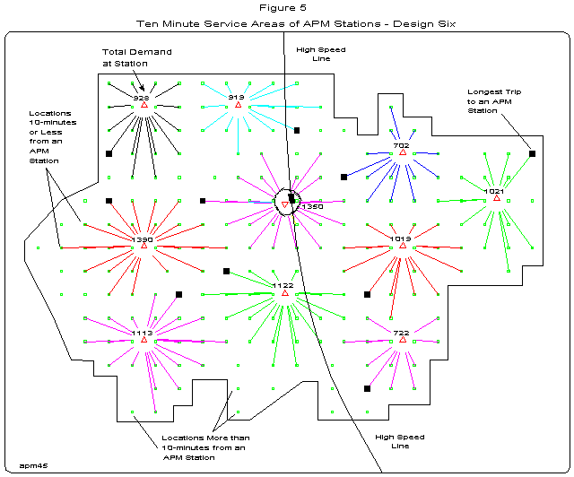
System performance results for the initial design are presented by using the several graphic displays produced by C-CAD. Other results are available in numerical form. One such display (not included here) shows what the service areas and workloads of each station would be for the initial design, under the assumption that everyone walks to the nearest APM station to use the circulator. The radial lines on this "starburst" display connects each APM station to those locations that are nearest to it (in time) and so define the boundaries of an idealized service area for each station. ( Figure 5 is an example of such a display)
This service area display shows the geographical extent of the service area of each APM station and the number of persons located in this service area (i.e. the station's expected workload). For the initial 7-station design, it shows that the expected workloads at each station vary, the values ranging from a high of 2,193 to a low of 809. This means that the high workload stations might have to be somewhat larger (physically) than those that have lower workloads. This performance display can be used to study the station location component of this design problem and can help the planner generate ideas about where it might make sense to add, delete or move a station. Typically, a planner would look for design changes that would equalize or balance the workload among the stations to the extent possible. For example, the planner might determine that the expected workload (809) at the most northwesterly station is too low to justify a station at that location and look for ways to modify the design to produce a workload pattern that does not have this problem.
The numerical performance measure values used to create these maps show that 26 percent of the demand can be reached within 5 minutes of the intermodal station, 72 percent within 10 minutes and 91 percent within 15 minutes. We interpret these figures as indicating that 91 percent of the demand in the MAC is "covered" within the 15 minute time interval. This value satisfies our first objective (at least 90 percent within 15 minutes) and our second objective is also met by the initial design (i.e. all APM stations can be reached from any APM station within 15 minutes). Another performance measure is the areawide average travel time from the intermodal station to all of these covered locations. Its value for the initial design is 8.2 minutes.
Moving Beyond the Initial Design
After reviewing and thinking about the results from the initial design, suppose that our "clients" decide that they want to achieve a higher coverage objective. Suppose that they decide that they want a circulator design that will place 90 percent or more of the demand within 10 minutes of the intermodal station, a level substantially higher than the 72 percent obtained by the initial design. To achieve this objective, it will be necessary to modify the initial design by adding more guideway segments and stations to it. These design modifications should be made so as to provide service primarily to those large concentrations of people not well served by the initial design.
This design modification/reevaluation process should start with a map that shows the locations that are uncovered (i.e. are beyond 10 minutes from the intermodal station) and their demand and C-CAD can produce such a map. This map can be used to generate ideas about how to modify the initial design to achieve this new, more demanding objective. Other maps can be generated and used to analyze the spatial characteristics of other performance measures. The first design modification selected was to add two new stations A reevaluation was computed and the performance measure calculations for Design #1 showed that the percent of the total demand within 10 minutes rose from 72 to 84.5 percent and that the average APM station access time (via walking) declined from 8.2 minutes to 6.8 minutes. This improvement in performance is clearly in the right direction but the new goal of 90 percent within 10 minutes has not yet been reached.
Five additional design modifications were made by looking primarily for ways to serve uncovered locations that have a large demand. Designs #2 and #3 involved only the shifting of one station to another better location. Design #4 involved moving a station and shifting some guideway. A tenth station was added in Design #5. A station was moved and some new guideway was added to obtain Design #6. Design #6 was found to meet the desired performance goal in that 91.4 percent of the demand was within 10 minutes of the intermodal station. The average travel time to an APM station was 6.4 minutes in this design, a reduction of 1.8 minutes from the initial design. Figure 3 shows the network layout for Design #6. It includes 10 stations and 12.42 miles (20.0 km) of mainline guideway as compared with 7 stations and 8.87 miles (14.28 km) of mainline guideway for the initial design. The total mainline guideway length was increased by 3.55 miles (5.72 km) or 40 percent in moving from the initial design to Design #6. Figure 4 shows those locations that are uncovered (i.e. more than 10 minutes from a station) in Design #6 as well as the size of the demand located at those nodes. As can be seen, the coverage for this design is quite good. Figure 5 is the service area (starburst) display for Design #6. Is shows the likely geographical extent and workload of each station in this design.
Discussion
The C-CAD program has been designed for use as a sketch planning tool early in the planning process. It allows the user to generate and evaluate a wide range of physical layout options quickly and easily and can be used to assess the general feasibility of a wide range of circulator concepts in the preliminary stages of a circulator system study. The results obtained can be used to provide the APM network needed in a subsequent travel demand analysis to estimate patronage, vehicle flow volumes and other more detailed operational measures (Hong, 1991; Green and Lott, 1989).
The purpose of this example has been to show how an intuitively-directly design process can be conducted with the aid the C-CAD program. For the example used, it was found to be possible to use the graphic displays to find design modifications that will, more often than not, produce the desired improvements in performance. The seven design modifications included in the example in this paper were generated and evaluated in less than one day of working at the computer. A novice user could not be expected to generate such results without some training and experience but the availability of the wide variety of graphic displays from C-CAD makes learning to use the program quite easy. Experience gained in using C-CAD in the classroom has shown that some novice users can produce successively better results with only minimal training and experience.
C-CAD can also be used to address a variety of "what-if" questions. An example might be "what if the high speed station was located on the edge of the activity center so that new high density development could be located around it?" What would the coverage figure be in such a case? A map can be derived quickly to address this question. Once available, all parties can discuss the trade-off required between the disbenefits of an additional few minutes of travel time and the possible benefits and disbenefits to the developer and the city of the proposed large scale mixed-use development around the edge location for the high speed station. Of course, we can expect the client to keep asking "what-if" questions as this debate evolves and other questions arise. C-CAD can be used provide data and graphics to help answer many, but not all such questions.
In this sense, C-CAD offers a spreadsheet-like functionality and a quick response time. Typically, persons reviewing a particular design will ask what would happen if a particular station were moved or a new station added or another section of guideway added. Often such questions arise unexpectedly, sometimes stimulated by political considerations or the plans of private developers that are often not known at the beginning of the design process.
One of the main strengths of C-CAD is its ability to produce graphic displays easily that can be used to communicate the performance characteristics of the design to a wide variety of persons effectively and comprehensively. This communication process can be made even more effective by using color displays and maps. All of the graphics produced by the C-CAD program are generated in color but color graphics have not been used in this paper because of their relatively high reproduction cost.
Several of the capabilities of the C-CAD program have not been discussed or illustrated in this paper because of space limitations. Chief among these is an optimizing subprogram (called Optimal) for finding the "best" locations for APM stations. Here, "best" means that the stations selected by the program will be as close as possible to the people who need to reach them. The planner needs only to indicate how many stations are desired and the program finds the best locations for them. A third C-CAD component is a network editor. It is an integral part of the program and allows the user to edit the database quickly and easily.
Applications of C-CAD are not APM technology dependent. It can be used to examine any people-mover technology that the planner is interested in evaluating. Each technology is specified only in terms of its route locations (one-way or two-way, their lengths and their peak-period and off-peak period speeds). Transfer delays can also be included if appropriate. For example, C-CAD could be used to compare a conventional bus system with an APM system or to examine a circulator system that uses both buses and an APM technology. Each technology requires its own network that must be specified in a link-node format. When multiple networks are used, the program will use the shortest paths regardless of mode in making its performance calculations. For buses, the delays caused by signals at intersections can be modeled in the same way as a transfer delay. The delays caused by congestion on the street system can be modeled as lower speeds on the links of the street system.
Some work has been done recently that is aimed at automating the design process described above (Ma and Schneider, 1991). While promising in many respects, the software developed by Ma for this purpose is not yet able to handle a network of the size described in this paper. Moreover, it is currently difficult to modify (edit) the network database components of this program so as to answer "what-if" questions quickly. Still, it is possible that this program will be improved in the future to the point where it can compete effectively with the human-computer interactive design process described in this paper.
Conclusions
It has been found that an intuitively-guided design process that makes extensive use of graphic displays can produce a high performance circulator system design in a very short time. With the graphic displays, the planner can quickly identify the weaknesses in any particular design and the graphic also provides a set of cues as to how to change the design to improve its performance. This same process is flexible enough to allow the planner to respond to changes in design objectives and/or constraints quickly, a requirement that is always present in any planning study, especially those that are dealing with a topic which is relatively new and for which there are few operating examples.
The approach outlined and illustrated makes full use of the planner's detailed site knowledge and ability to "see" spatial relationships while also providing full access to the extensive memory and calculation capabilities of the computer. Clearly, there are many possible design solutions to the type of problem illustrated in this paper. Within a week, it would be possible to generate and evaluate 5-10 of these design solutions and to compare them using a multicriteria evaluation technique (Janarthanan and Schneider, 1989). No claim is made that the "optimal" solution would be found by such a process but it is very likely that several high performance designs would be found and that one of them would be highly satisfactory to the client.
In the future, it may be possible to devise an automated design process that could generate an "optimal" solution to this problem for a network of reasonable size. Until then, the intuitively-guided process described in this paper offers an inexpensive and fast way to generate high performance circulator system designs quickly and in a way that can be very responsive to frequent, unexpected and major changes in design objectives and constraints.
References
Anderson, J. Edward, 1988, "The TAXI 2000 Personal Rapid Transit System", Journal of Advanced Transportation, 22:1, 1-15
Cervero, Robert, 1988, America's Suburban Centers: A Study of the Land Use-Transportation Link, Final Report, DOT-T-88-14, Prepared for the Office of Policy and Budget, Urban Mass Transportation Administration and the Rice Center for Urban Mobility Research, 176 pp
Ettenger, William, 1989, "Integration of APM Systems with Florida High Speed Rail," in Automated People-Movers II, edited by Bondada, Sproule and Neumann, American Society of Civil Engineers: New York, pp 799-807
Garreau, Joel, 1991, Edge City: Life on the New Frontier, Doubleday: NYC, 546 pp
Green, James W. and J. Sam Lott, 1989, "The Application of Integrated, Computerized Planning Tools to Assist in the Analysis and Design of Automated Transit Systems in Major Activity Centers," in Automated People-Movers II, edited by Bondada, Sproule and Neumann, American Society of Civil Engineers: New York, pp 116-128
Janarthanan, N. and J. Schneider, 1989, "Development of an Expert System to Assist the Interactive Graphic Transit System Design Process," Transportation Research Record, No. 1187, National Academy of Sciences/Engineering, Washington, D.C.
Kulash, Walter, Michael Brown and Frances Chandler, 1989, "People-Movers in High Activity Centers," in Automated People-Movers II, edited by Bondada, Sproule and Neumann, American Society of Civil Engineers: New York, NY, pp 808-818
Hong, Soonman, 1991, The Development and Application of Analytical Methods for Evaluating Circulator Transit System Alternatives Within/Around Major Activity Centers, unpublished Ph.D. dissertation, Department of Civil Engineering, University of Washington, October, 1991, 312 pp
Ma, Jun and J. Schneider, 1991, Designing Personal Rapid Transit (PRT) Networks, Journal of Advanced Transportation, 25:3, pp 247-268
Schneider, J.B., 1992a, Selecting and Evaluating the Number and Locations of Stations for an Intercity High Speed Ground Transportation Corridor in the U.S., Discussion Paper 92-1, Transportation Systems Program, Department of Civil Engineering, University of Washington, Seattle, WA, 22 pp
Schneider, J.B., 1992b, Assessing the Station and Access System Design Implications of a Small Vehicle Maglev Ground Transportation System, Discussion Paper 92-2, Transportation Systems Program, Department of Civil Engineering, University of Washington, Seattle, WA, 20 pp
Schneider, J.B., 1992c, Integrating High Speed Intercity Transportation Systems and Local Circulator Systems with the Existing Ground Transportation Systems in Suburban Areas, Discussion Paper 92-3, Transportation Systems Program, Department of Civil Engineering, University of Washington, Seattle, WA, 51 pp
Schneider, J.B., 1992d, "A PRT Deployment Strategy to Support Regional Land Use and Rail Transit Objectives," Transportation Quarterly, 46:1, 135-153
Schneider, J.B. and Soonman Hong, 1991, Development of Methods of Analysis for Planning Transit System Components in and around Major Activity Centers, Part II: Final Report TNW 91-13.2, TransNow, University of Washington, Seattle, WA
Technical Committee on Personal Rapid Transit, 1988, "Personal Rapid Transit (PRT): Another Option for Urban Transit?", Journal of Advanced Transportation, 22:3 (entire issue), pp 196-314
Xiong, Y. and J.B. Schneider, 1992, User's Guide for the C-CAD Program, Transportation Systems Program, Department of Civil Engineering, University of Washington, Seattle, WA, 55 pp
Key Words
circulator, major activity center, computer-aided design, interactive graphics, sketch-planning, design/redesign process, intuitive design, apm route planning, apm station location planning, edge cities
Jerry Schneider is Professor Emeritus in the Departments of Civil Engineering and Urban Planning and Design, at the University of Washington, in Seattle, Washington. are welcome. Comments are welcome.
Last Modified: June 30, 2010