NAVIGATIONAL
CONCERNS
Navigational Impacts
Prior to the construction of the
dams the river was not sufficient to allow commercial navigation down the river.
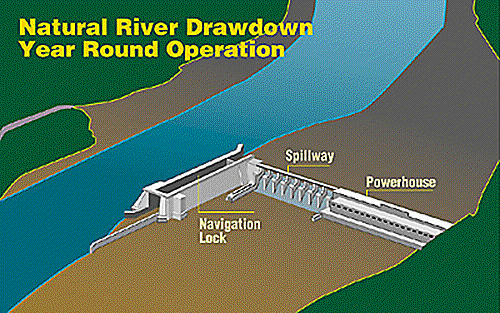
The construction of the Ice Harbor Dam, located at river mile 9.8,
creates a 32-mile reservoir called Lake Sacajawea that allows barges to be
floated to the Lower Monumental Dam. The
Lower Monumental Dam, located at river mile 41.6, creates Lake Herbert G. West
that is 28.7 miles long and allows barges to be floated further upstream to the
Little Goose Dam. The Little Goose
Dam, located at river mile 70.3, creates Lake Bryant that is 37.2 miles land and
allows barges to be floated further upstream to the Lower Granite Dam. The lower Granite Dam, located at river mile 107.5, creates
Lower Granite Lake that is 37.3 miles long and allows barges to be floated into
a harbor at Lewiston Idaho. Port
Lewiston is the world’s most inland sea port.
This port would be eliminated if the dams were breached.
The total trip to Port Lewiston is 465 miles long. Along the way the
vessel pass through eight locks, four on the Columbia, Bonneville Dam, The
Dalles Dam, John Day Dam, and McNary Dam, and the four previously mentioned on
the Snake River. The elevation change from the ocean to Port Lewiston is 740
feet. In addition to providing navigation down the river the dams provide
hydroelectric power and flood control facilities.
From the ocean to Portland, Oregon
and Vancouver, Washington a distance of 106 miles the Columbia River is dredged
to a minimum depth of 40 feet. This
allows ocean going vessels access to the Portland/Vancouver port.
Just east of Portland is the first dam, Bonneville Dam.
For the remaining 359-mile trip these eight dams maintain the water
elevation. From Bonneville
Dam to Port Lewiston along the Columbia/ Snake River system the water level is
maintained by the eight dams to keep a minimum water depth of 14 feet.
This minimum depth is sufficient to allow barge traffic up and down this
river system.
There is 17 million tons of cargo
that enters the Columbia River from the ocean the vast majority of this cargo is
unloaded at Portland/ Vancouver. Very
little cargo is moved east of Portland by barge. Most of the barge traffic down
the Columbia/ Snake River system is agricultural harvest that is loaded in
Lewiston and shipped down to Portland.
The other major product that is
transported down the river is salmon. In
accordance to the Endangered Species Act (ESA) the salmon population must be
protected. All eight dams located
from the ocean to Lewiston, Idaho are equipped with fish ladders.
The fish ladders are successful in allowing adult salmon to migrate up
steam to spawn. Research have
showed that salmon fry, immature salmon, are not successful in negotiating the
fish ladders an their voyage out to sea. To
comply with ESA the Army Corps of Engineers catches salmon fry and barges the
fish downstream below the Bonneville Dam. The
salmon fry are released upstream of the estuary, in an area that is still
freshwater. The fry then begin
their transition and accommodations for a saltwater environment.
The Army Corps of Engineers send $350 million per year on this salmon
recovery program.
If the dams along the Snake River
were breached agricultural products that were barged would need to find an
alternate means of shipping. Currently
the major navigational use of the river is to move fish that are indigenous to
the river, and agricultural products to market. For moving agricultural products to market the federal
government subsidizes this navigational system at an amount of $43 million per
year. This is in addition to the
$350 million spent each year for salmon recovery.
The proposed method to breach each dam is to remove the earthen sections
of the dam leaving the concrete structures.
The following is a sketch illustrating the changes.
|
|
 |
If the dams were breached the
area would need to develop an alternative transportation system.
This would be accomplished with a combination of rail lines and highways.
The port that is located in Lewiston, Idaho would need to be located in
the TriCities near the confluence of the Columbia and Snake Rivers. Estimates of infrastructure cost improvements for
highways and railway lines are approximately $267 million.
Assuming a federal/state cost sharing of 75/25 and no other sources then
the federal government’s share would be $200 million. Considering that the government is subsidizing the barge
system. The federal government
would realize a ten-year return on their investment.
This does not include the additional revenues that would be derived from
fuel taxes and truck licensing fees.
Some of the major complaints of
eliminating this navigational system are, can the area operate a rail system,
and what will this change do to the agricultural industry in the area.
From an administration perspective, the development of the rail service
to the region would be no problem. The State already has in place the State’s
Freight Mobility Strategic Investment Board.
This board establishes priority criteria of transportation projects in
the state and identifies federal and state funding partners.
The State of Washington has developed a state subsidized grain
transportation system called the “Grain Train.”
In 1995 the state purchased 29 rail cars to provide an improved railcar
transportation system for agricultural interests in the TriCities region. This program has been so successful that in 1998 the state
purchased additional 36 railcars for total 65 railcars.
This system could easy be expanded to serve the Lower Snake River region.
As for the changes to the agricultural economy, when barge traffic was
introduced along the Snake River in the 1960’s and 1970’s there no
noticeable increase in agricultural activities in the region, there was no large
increases in plant able acreage. It
is anticipated that if the dams were removed there would be little impacts to
the number of acres planted. Future
job prospects as developed by Washington Department of Economic Security are
anticipated to continue in decline in the area.
The state has estimated the loss of 1,753 agriculture-related jobs
between 1996 and 2006.
Bypassing the dams would eliminate
the barge traffic along the Snake River. This
barge traffic is to ship grain to market. Investments in highway and rail systems could provide a
reasonable alternative. Improving
the railway service would be a significant financial boost to that industry,
potentially spawning new industrial development in the area. These improvements
in the transportation system would provide additional benefits to the residents
of the area with improved roads and possible rail service to the area.