We used King County's RECDNET as the major input for parcel
boundaries and PINs. In addtition, we used MetroScan data for many of the
parcel attribute items necessary for the filtering and calculation algorithms.
The other necessary parcel attribute items were generated from topological
overlays of the City’s zoning and comprehensive plan coverages.
The first task was to extract necessary data from the MetroScan data. Based on the County's tax levy codes, we were able to select the parcel records we knew to be within SeaTac city limits. These records were then exported from MetroScan's native data format to dBase IV format. The Arc command dbaseinfo was used to convert this format to an INFO table.
However, because the resultant table was not spatially explicit, it had to be joined with the parcel coverage's PAT. Thus, we clipped the RECDNET coverage with the city limits coverage to create a city parcel coverage, and, did a joinitem of the RECDNET.PAT and the MetroScan INFO table to create a parcel coverage with most of the attribute items we needed for the analysis.
Because some of the structure of the raw RECDNET data, many parcels were split along sheet faults or other linear breaks. In order to calculate realistic area for parcels, we performed a dissolve to merge adjacent polygons with the same PINs.
We knew that several of the steps we needed to take would split polygons and rebuild topology This would result in constantly updated parcel areas, although we knew we needed a single, consistent value for original parcel area. Therefore, early on, we created an item to hold the original area of each parcel. We performed several additem commands (for each attribute to be fixed) and calculated these new items equal to the original attribute values of the polygons in RECDNET.
Buffer Streams and Wetlands
According to the SeaTac Zoning Code, developments can only take place beyond specified distances from streams and wetlands. Streams are buffered by 25, 50, or 100', based on their significance.
Wetlands are buffered to 0, 35, 50, or 100', based their significance.
Regulations dictate that no development will occur within these distances of streams and wetlands. For this reason, we buffered streams and wetlands to the distances dictated by the Zoning Code. Any parcels completely enclosed within the buffered areas (including the buffered features) were removed from consideration of redevelopment. Any parcels partially overlapping with the buffered areas were not removed from consideration, since it is possible, according to regulations, for a landowner to develop on non-critical land within a parcel, even if part of the parcel contains critical areas.
Flag Steep Slopes
We initially thought that steep slopes were going to disqualify certain parcels from redevelopment. However, when we identified areas of 40%, this only flagged small portions of selected parcels. Under current regulations, if a portion of a parcel is considered unbuildable, it is acceptable for the landowner to build up to the allowable density on any portion of the parcel. For this reason, steep slopes were not included in the overall analysis.
We needed baseline data (current counts of housing units and employees) before making any projections into the future, since the analysis called for the net number of new housing units and employees.
Housing Units
For single-family residences, MetroScan listed 0 units. Therefore, we calculated the total existing units = 1 for single-family residences. Since MetroScan does not have data on the number of units in mobile home parks, we also used the city's best records to update the number of mobile home residence units, which we were able to do by selecting PINs known to be mobile home parks.
Employees
Ideally a jurisdiction will have current employment data from its business license records. By business address, this data could be linked to parcels to yield a number of current employees for each parcel. In the absence of such current information, an alternate method is possible.
Based on the building square footage of existing commercial
and industrial parcels, we were able to estimate the number of employees
supported by each commercial-industrial parcel. Table 2 shows the square
footage per job assumption.
SQ.FT./EMPLOYEE | |
| AI | |
| BP | |
| CABC | |
| CH | |
| CL | |
| CM | |
I |
An integral part of the analysis was to apply planning rules to parcels in order to generate projections for future development. Therefore, we needed to union the current and potential zoning coverages with parcels. The new data allowed us to look at qualities such as housing densities and intensity of commercial-industrial land use. This combination of parcel and planning data was central to the analysis as a whole. Without the existence of the planning data themes, none of the analysis would have been possible.
Part of the analysis, although not required by the task force, was to also identify the same basic criteria which were applied to the city as a whole, but limited to the Urban Center. Therefore, we also performed a union with the urban center polygon coverage.
Because the city contains SeaTac International Airport completely within its boundaries, and also because the same redevelopment prescriptions were not applicable to airport polygons, we needed to flag parcels within the airport for later removal from the databases. This necessitated performing a union of the parcel-zoning coverage with the airport boundary coverage.
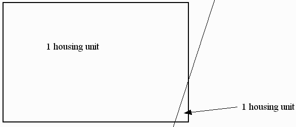
The final GIS step in the analysis was to remove "sliver" polygons from the data summaries. These were not considered significant in the amount of area they might contribute, but in the number of erroneous employees and/or housing units they might have contributed (Figure 4).
Simply removing slivers of a certain size, we felt, lacked control. Instead, we looked at the ratio of polygon area to lot square feet (from MetroScan). Where this ratio was small (meaning that the GIS-calculated area was much smaller than the reported area), and the overall size of the polygon was small, we eliminated these polygons. The cut-off point was a polygon size less than 300 and an area to lot square foot ratio less than or equal to 0.1. We determined that if a polygon met these criteria, it was a sliver from a parent polygon of at least 3000 sq. ft. The parent polygon would still exist, and we would simply add the sliver areas back in with the parent polygon.
As mentioned previously, we needed to remove certain parcels from the analysis. These parcels represent parcels which are assumed to remain in the same use for the duration of the 20-year planning horizon, and therefore do not represent any development potential. The exceptions are listed in Table 3.
| Airport |
| Schools |
| Fire Station |
| Utility-related parcels (e.g., water, electrical) |
| Specific residential units. |
The specific residential cases were found where an apartment building straddled 2 or more parcels. MetroScan data for number of units, assessed value, building area, etc., was recorded for only a single one of the parcels, with the other parcels appearing essentially undeveloped. We looked at each one of these cases in detail, and found that none met our redevelopment criteria, and were therefore dropped from the calculations of new housing units.
This is an example of where using GIS enhanced the accuracy of the analysis: without being able to see the building to land relationship, we would have assumed all but one of the parcels in each of these cases to be vacant, and therefore represent development potential.
Once we had all the steps we could do in the GIS, we exported the PAT into a dBase IV file via the infodbase command. This was imported into Microsoft Access, which was the engine for the actual calculations of net new employees and housing units.