NGO Activity
in Vietnam: A Cartographic Exercise
by Joe Hannah
Department of Geography, University of Washington
In the Fall of 1999, I entered the graduate program in the Geography
Department of the University of Washington, in Seattle. The maps on this
page are from a project I did for an introductory Geographic Information
Systems (GIS) course.
The maps I produced for this project attempt to visually correlate NGO
activity in Vietnam with two variables, provincial GDP and provincial population
density. My intention was to illustrate whether NGOs decide to work in
areas based on these criteria (as indicators of poverty conditions) or
by other (undetermined) criteria. It must be said at the outset that the
level of analysis in this project is very rudimentary; the project was
predominently a mapping excersize, rather than a careful analysis of NGO
behavior.
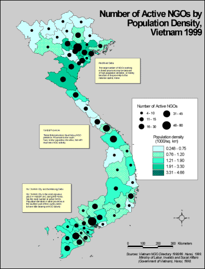 |
NGO Activity by Population Density
This first map shows provincial population densities and NGO activity.
No strong correlation is evident.
-
Red River Delta -- The large number of NGOs working in these provinces
may be because of high population densities, or merely because of the proximity
to the national capital, Hanoi.
-
Central Provinces -- The three provinces of Quang Tri, Thua Thien-Hue,
and Quang Nam- Da Nang have heavy NGO presence. Provinces to the south
have similar population densities, but with much less NGO activity.
-
Ho Chi Minh City and the Mekong Delta -- Ho Chi Minh City is the most populous
place in Vietnam and, along with Hanoi, has the most number of active NGOs.
Population densities in other provinces in the southern part of the country
seem to have little bearing on NGO activity.
|
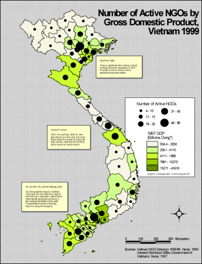
NGO Activity by Provincial GDP
The second map shows provincial gross domestic product (GDP) and NGO
activity. Again, no strong correlation is evident:
-
Red River Delta -- There is significant NGO activity in most of these provinces,
regardless of GDP. Proximity to Hanoi may be a more important factor than
wealth.
-
Central Provinces -- NGOs are working in both rich and poor provinces in
this area. The closer to the cities of Hue and Da Nang, the more activity,
indicating the deciding factor may be air transportation.
-
Ho Chi Minh City and the Mekong Delta -- This the wealthiest region of
Vietnam. Once again we see more NGO activity near the major metropolis,
rather than in more remote and poorer provinces a few hundred kilometers
to the north. Transportation may be a deciding factor for siting NGO projects.
|
 |
What the Maps Say
The level of NGO activity in various provinces is fairly well illustrated
in these maps. What is less clear is any correspondence with the variables
that I chose to map GDP and population density. In some cases a group
of provinces seems to show a positive correlation, but another group of
provinces may show a negative correlation. Therefore I would conclude that
neither of these variables is a determinant for NGOs choosing project sites.
This conclusion validates my own experience in Vietnam. First of all,
it became clear during the project that neither GDP nor population density
are adequate indicators of poverty. For instance, I know that NGOs do try
to target poor areas, which might be either areas of extremely high population
density or remote, less dense areas. Further studies with more comprehensive
variables for poverty are needed.
Secondly, the problems of transportation, costs of operation, and availability
of local staff are more likely to constrain site selection. Practicality
curtails ideal choice. Further studies should look at these factors --
the correspondence of site selection with major airports and good roads,
for instance. A more detailed look, at a district level rather than provincial,
would also be much more informative.
Data Issues and Sources
Data was a serious problem in this project. The biggest challenge was
that the base map was made prior to 1998. Unfortunately, in that year,
the government of Vietnam redrew the provincial boundaries for eight provinces,
splitting each of them into two separate provinces. My NGO, GDP, and population
data used the new provincial boundaries, while my base map used the old.
Fortunately I was able to determine which provincial boundaries changed
and in what manner, so was able to map all the new data to the old provincial
boundaries. I am told a new base map of Vietnam will become available from
the government of Vietnam soon, though I have yet to see it.
Base Map and Provincial Land Area:
Obtained from ESRI's on line database. This is ESRIs description
(from their web site www.esri.com) of their online base map data:
"The ArcData Online collection World Basemap Data includes data layers
from a variety of ESRI products, including ArcWorld ArcAtlas, Digital Chart
of World, and Data and Maps. ESRI has assembled these products into a single
Spatial Database Engine (SDE) database to provide a continuous display
of basemap data from a small-scale global display to a medium-scale regional
display."
NGO Activity:
Forum on Cambodia, Laos and Vietnam. Vietnam NGO Directory
1998/99. Hanoi, July 1999.
Population:
Ministry of Labor, Invalids and Social Affairs (Government
of Vietnam). Thuc Trang Lao Dong Viec Lam O Viet Nam. [Status
of Labour Employment in Vietnam] Hanoi 1998.
General Statistical Office (Government of Vietnam). Tu Lieu Kinh
Te Xa Hoi Chon Loc Tu Ket Qua Cac Cuoc Dieu Tra Qui Mo Lon Nhung Nam
1990-1996. [Major Social and Economic Information Obtained from
the Large Scale Surveys in Period of 1990-1996] Hanoi 1998.
Provincial GDP:
General Statistical Office (Government of Vietnam). 1997 (unpublished).
Please feel free to send any comments or questions to me at jhannah@u.washington.edu