Time Dependent Inflation of Three Sisters Volcano
Project Collaborators: Susan Riddick, David Schmidt
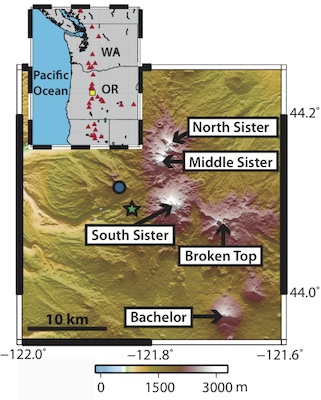
 The Three Sisters volcanic center is one of the most active areas of the Cascade Range and one of the most densely populated vent areas in the world [Hildreth, 2007]. A wide spectrum of volcanic hazards, as well as newly discovered deformation in 2001, requires this area to be continually monitored [Wicks et al., 2002]. We contribute to the monitoring effort for the Three Sisters region by more fully documenting the time-dependent uplift related to the injection of magma at depth. We use InSAR data from 1992 through 2010 to create line-of-sight time series and characterize changes in the volcanic source behavior in time. Utilizing persistent scatterer InSAR time series, small-baseline time series, and stacking, we refine the onset of the volcanic activity as well as determine whether the source is still inflating. By using an inflation time series, we are able to quantify the volume of magma injected into the crust and provide a more temporally complete timeline of the activity. By spatially and temporally inspecting the ground uplift, we hope to improve our understanding of the source, the hazards associated with this intrusive episode, and the potential for future activity in this region.
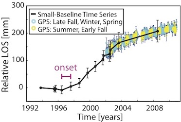
We interpret the deformation to be caused by the intrusion of magma at depth, resulting in ~25 cm of uplift through 2010. The uplift began gradually between late summer of 1996 and summer of 1997, and then increased to ~3-4 cm/yr from 1998 through 2003. A marked decrease to ~20% of the peak uplift rate occurred in 2004 and continued through 2010. This change in intrusion behavior may be related to the seismic swarm that occurred in late March of 2004. In 2010, the uplift rate is near the magnitude of the noise, but appears to be holding constant at about 6-8 mm/yr.

We explored the source of the deformation by modeling the InSAR data assuming a Mogi point source, a tension crack, and an ellipsoidal pressure source. All models describe the deformation equally well based on the fit to the data, and consequently we cannot resolve whether the source shape is spherical, sill-like, or ellipsoidal. But considering geophysical constraints and field data, we hypothesize that the source is most likely a sill of basalt at a depth of 7 km. The total volume of magma intruded as of 2010 for a sill-like source is ~6 x 10 7 m3. The Three Sisters area should be continually monitored because of the ongoing intrusion and the likelihood of future intrusive episodes. The duration, volume, and repeat time of these intrusive episodes are important for determining the potential volume of magma stored at depth as well as its likelihood of erupting.
The results are fully documented in Riddick and Schmidt (2011).
References
Hildreth, W. (2007), Quaternary Magmatism in the Cascades-Geologic Perspectives, U.S. Geol. Surv. Prof., 1744.
Wicks, C.W. Jr, D. Dzurisin, S. Ingebritsen, W. Thatcher, Z. Lu, and J. Iverson (2002), Magmatic activity beneath the quiescent Three Sisters volcanic center, central Oregon Cascade Range, USA, Geophys Res Lett, 29, 1122, doi:10.1029/2001GL014205.
