The University of Washington owns and maintains a series of biological preserves in the San Juan Islands, San Juan County, Washington. The five preserves, located on San Juan Island and on Shaw Island, have very different histories of acquisition by the University. The Cedar Rock Preserve, the Fred and Marilyn Ellis Biological Preserve, and the Friday Harbor Laboratories Biological Preserve were given to the University and have explicit deed restrictions that run with the properties and govern their use. The False Bay and Argyle Lagoon preserves were purchased by the University of Washington and are presently administered along with adjacent shoreline areas as Washington State Department of Fish and Wildlife (WADFW) fisheries preserves, as is the shoreline of the Friday Harbor Laboratories Biological Preserve and some of the shoreline of the Fred and Marilyn Ellis Biological Preserve.
The San Juan Archipelago Biological Preserves are otherwise administered by the Director of the Friday Harbor Laboratories, who is advised by the University of Washington San Juan Islands Biological Preserves Committee. In October 2005, this new committee agreed upon the following vision statement for all of these preserves:
The overarching goals for these properties are to maintain and restore native biodiversity and ecosystem function and to facilitate education and research that is consistent with these goals; a secondary goal is to maintain important parts of the cultural landscape.
The five Preserves are described and discussed separately, below.
Cedar Rock Preserve, Shaw Island
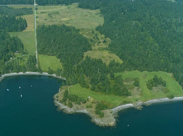
Cedar Rock Preserve, Shaw Island. Image © State of Washington Department of Ecology, Shoreline Aerial Photos, August 23, 1995, shows approximately the western 1/2 of the Preserve, which is bounded to the west by Hoffman Cove Road running vertically near left side of image.
This is a 370 acre property composed of 10 contiguous parcels that form roughly a pentagonal shape, given to the University of Washington by Robert Ellis of Shaw Island in 1973 and 1983; two more small parcels were added to the Preserve in 1986. The Preserve lies on the south-central shoreline of Shaw Island and is bounded to the west by Hoffman Cove Road, to the north by Squaw Bay Road, to the east by the waters of Squaw Bay and to the south by Upright Channel. Road access is by Hoffman Cove Road or Squaw Bay Road.
The upland portion of the Cedar Rock Preserve is a mosaic of second-growth, Douglas fir-dominated, mixed conifer forest with a number of open rocky balds, old fields that were used for farming and for an airstrip until the mid-1970s, several orchards of various sizes and in various states of disrepair, a small central pond, and a narrow strip of coastal prairie bounding much of the shoreline. The homesteading histories and more recent agricultural use of these properties have led to the rich and varied (open and forested) nature of the present Preserve lands.
 The 2.3 miles of shoreline of the Cedar Rock Preserve is mostly low-bank bedrock, interspersed with gravel/cobble beaches.
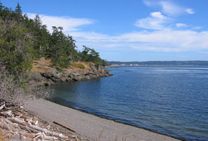
South-facing beach just east of the Cedar Rock. Photo by Claudia Mills, 2006.
A resident part-time caretaker lives in one of two small houses on the Cedar Rock Preserve and is available to oversee all of the UW properties on Shaw Island, although his primary responsibility is to the Cedar Rock Preserve. There are minimal facilities for individual researchers or classes to stay overnight on this Preserve, or it can be reached by small boat or car-ferry by researchers or students choosing to stay in housing across San Juan Channel at the Friday Harbor Laboratories on San Juan Island.
A management plan for the Cedar Rock Preserve (the pdf file is about 4 MB - note that if you download and read this plan on your computer, that the aerial photographs can be magnified many times on your screen by using the "+ zoom button" at the top of the pdf file) was completed and accepted by the University of Washington San Juan Islands Biological Preserves Committee in summer 2008. The management plan will be updated as required. The Cedar Rock Preserve is presently open for day-use; visitors without an approved project are asked to stay on established trails in order to minimize disturbance of the flora and fauna.
The deed restriction that runs with this property and guides its future states: “That the premises herein conveyed shall forever be held, used and maintained as a nature preserve for scientific, educational, research and aesthetic purposes, and shall be kept in their natural state without disturbance of the native plant, bird and animal populations and habitat. Nothing contained herein shall restrict the grantee from maintaining existing buildings or constructing new ones, provided that they shall be inconspicuous buildings appropriately designed for the environment, nor from constructing piers or docks, roads, fences, foot trails and fire trails on the premises, nor from making modest modifications in the environment, all only as the grantee deems necessary to maintain the premises for the purposes described herein. … Cedar Rock Preserve is dedicated to the glory of nature and is established in grateful remembrance of my parents, Blanche Eloise Day Ellis and Robert Hale Ellis, whose judgment and foresight have made this possible.”
Fred and Marilyn Ellis Biological Preserve, Shaw Island
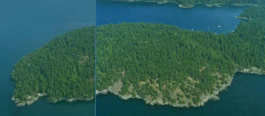
Point George peninsula, Fred and Marilyn Ellis Biological Preserve, Shaw Island. Images © State of Washington Department of Ecology, Shoreline Aerial Photos, August 23, 1995, show approximately 1/4 of the Preserve. San Juan Channel in foreground; Parks Bay in background; north is to the left.
This Preserve consists of 496 acres in three large, non-contiguous properties composed of thirteen parcels that were given to the University of Washington in 1969, 1976, 1981, 1982 and 1988 by Fred and Marilyn Ellis of Shaw Island. The Point George portion of the Preserve is a 176 acre boot-shaped peninsula on the west side of Shaw Island, including the southwest shoreline of Parks Bay, and consists of four contiguous parcels of land and one tideland parcel; there is no road access to this peninsula, but it can be reached in a few minutes by small boat from the Friday Harbor Labs, across San Juan Channel. A second, roughly rectangular portion of this Preserve lies on the northeast shoreline of Parks Bay, and consists of two continuous parcels totaling 172 acres, and a 7.1 acre parcel a little further west, also bordering Parks Bay, but discontinuous with the rest; there is no direct road access to most of the Parks Bay portion of the Preserve, although it can be accessed on foot with permission from adjacent property owner (and Preserve donor) Fred Ellis. The Parks Bay portion of the Preserve is also easily accessible by small boat from the Friday Harbor Labs. The third, Ben Nevis area, portion of the Preserve is a roughly-square 140 acre property, entirely landlocked, made up of 6 contiguous parcels and is bounded on three sides by roads: Neck Point Road runs along on its south and western edge and the eastern edge is bounded by the Ben Nevis Loop road.
Uplands of the Fred and Marilyn Ellis Preserve are mostly heavily forested with second-growth Douglas fir-dominated, mixed conifer forest, with a number of rocky balds forming openings throughout. Much of the SE quarter of the Ben Nevis portion is wetland, with standing water during the winter months.
The 2.9 miles of shoreline of the Fred and Marilyn Ellis Biological Preserve includes mostly low-bank bedrock, interspersed with muddy beaches within Parks Bay, and is mostly fairly low-bank bedrock on almost all of the outside of Point George. UW owns 2,315 linear feet of tidelands along Point George as part of this Preserve. The shoreline on the west side of Point George is now managed as one of the five Washington State Department of Fish and Wildlife (WADFW) fisheries preserves established in 1990, known collectively as the “San Juan Islands Biological Preserves.”
There are no buildings or other structures on this Preserve and most of it sees little or no human traffic. It is not open to the public, but visits can be arranged. The property was conveyed to the University of Washington with the following conditions: “The property is to forever remain substantially untouched by our rapidly expanding civilization. Thus, it is the donor’s purpose in making this gift that the property be kept in its natural state and become a scientific preserve. Except for teaching and research in the biological and related sciences, the uplands and intertidal areas shall continue to be a natural, self-regulatory ecological unit without substantial interference or disturbance by man of the natural communities, habitat or population of plants, birds and animals.”
Friday Harbor Laboratories Biological Preserve, San Juan Island
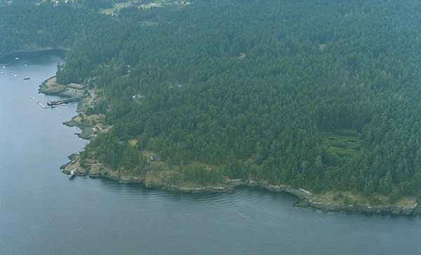
Friday Harbor Laboratories Biological Preserve, San Juan Island. Image © State of Washington Department of Ecology, Shoreline Aerial Photos, August 23, 1995, shows approximately 1/3 of the Preserve. The developed property on the left-hand side of the image is the University of Washington Friday Harbor Laboratories, a marine field station - the "campus" portion of the Preserve. The town of Friday Harbor is about 1/4 mile away, off the left-hand edge of this photograph.
This is a 476 acre property (originally acquired as 484 acres, reduced to 476 acres when the western line was resurveyed in the early 1990s to resolve questions about its location), roughly hemispherical in shape, with the curved portion projecting out to the east into San Juan Channel, and bordered to the south by the bay of Friday Harbor. This former U.S. Military Reserve was transferred to the University of Washington in 1921 by the federal government “for the purpose of a biological station and for general university research purposes,” but can be taken back in time of war (and was closed and used under this provision as a Coast Guard training facility during WWII). The western border is a straight line running approximately north/south and is bounded by suburban development throughout its length, in the form of the neighborhoods of University Heights, Hillview Terrace, and then houses, townhouses and apartment buildings accessed from University Road and Tucker Street in Friday Harbor. The Friday Harbor Laboratories Biological Preserve is accessed by University Road, which terminates at the University of Washington Friday Harbor Laboratories campus portion of the property.
Approximately 100 acres of the property, in the southeast corner, is zoned “Conservancy,” the southern portion of which is developed as a residential teaching and research campus, including 12 separate laboratory buildings, 2 lecture halls, the Whiteley study center, a library, administrative offices, stockroom, dining hall, dormitories and a variety of housing units from small apartment buildings to duplexes, to single family units. (The residential population of the campus varies during the year between about 30 and 200 persons.) Most of the remaining nearly 400 acres is zoned “Natural” and is Douglas fir-dominated, mixed coniferous forest, with some open rocky and mossy bald areas.
Dr. Tom Schroeder, cell biologist who worked at the Friday Harbor Laboratories for nearly 30 years, has written a 500 year history of the property that now comprises the Friday Harbor Labs Biological Preserve and some surrounding land, arguing that its present densely-forested state is a result of land use change in the past century, as European settlers replaced indigenous peoples. A baseline inventory of the plants present on the FHL Preserve, by habitat type, was made by Claudia Mills and others between 2001 and 2005, and includes some data from earlier collections.
The 2.6 miles of shoreline of the Friday Harbor Laboratories Biological Preserve is mostly medium-bank bedrock, with perhaps 8-10 small gravel beaches, widely separated. This shoreline is now managed as one of the five Washington State Department of Fish and Wildlife (WADFW) fisheries preserves established in 1990, known collectively as the “San Juan Islands Biological Preserves.”
This biological preserve is open access to campus residents and overnight visitors at the Friday Harbor Laboratories, who are asked to respect the Preserve nature of the property. The public may visit for day-use, but is asked to check in at the Office before venturing out into the Preserve and to stay on the well-traveled, wide, fire-access road (the “fire trail”) that runs through the forest.
False Bay Biological Preserve, San Juan Island
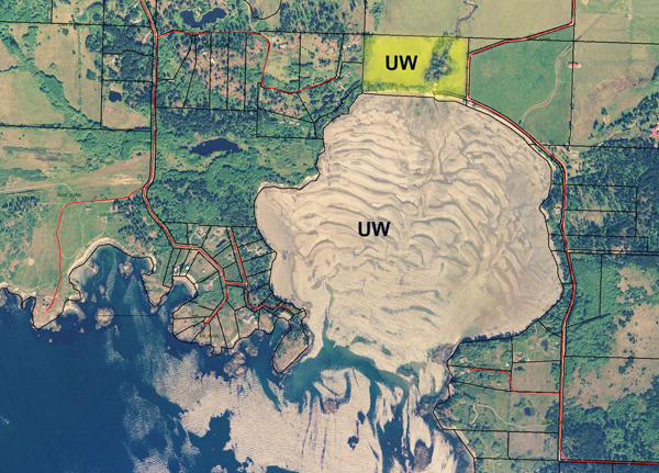
False Bay (~ 0.7 mile diameter, ~300 acres of tidelands), San Juan Island, photographed during a low tide with exposed sand flats. Image compiled from several screen shots, San Juan County Assessors Office parcel map (1995 images). The yellow-colored parcel above False Bay is the University of Washington upland portion of the preserve.
Purchased by the University of Washington in 1974 at auction following a bankrupt and foreclosed development scheme for several hundred homes on a grid of sand piers within the bay, this preserve includes most of the approximately 300 acres of tidelands in False Bay and a 23.3 acre upland property that borders the north end of False Bay and False Bay Drive and includes the lower reach and mouth of the stream that enters False Bay at that point. The False Bay purchase resulted in the University of Washington owning all tidelands in False Bay from shoreline to mean low water except from high tide line out 100’ in Government lot #4, owned by Mountain Shadows Development as community beach access, and from high tide line out 100’ in Government lot #6 , which is privately owned. There is also a portion of the center of False Bay that remains under State of Washington ownership; that portion is north of the line drawn across the northern edge of Government Lots 2 and 8, between mean low tide and extreme low tide.
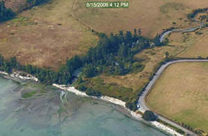
Lower reach and mouth of the stream entering the north side of False Bay through UW Biological Preserve uplands, San Juan Island. Image © State of Washington Department of Ecology, Digital Coastal Atlas, August 15, 2006, photographed during a high tide when the bay is filled with water.
The uplands are partially open grassland and partially forested. Typically the stream flows fairly freely into False Bay, although in 2008, the stream was dammed by logs well-embedded in sand at the high tide line, and did not flow freely out into the bay. Land access to False Bay is from False Bay Drive, which borders both the marine and terrestrial properties owned by University of Washington.
False Bay empties nearly entirely at lower low tides. The central tidelands are primarily sand flat, tending towards muddy in some areas, but generally easy to walk on. The shoreline edges are mostly muddy sand with small areas of bedrock extending down into the intertidal from shore. The University of Washington manages the waters and intertidal of False Bay as one of the five Washington State Department of Fish and Wildlife (WADFW) fisheries preserves established in 1990, known collectively as the “San Juan Islands Biological Preserves.” That portion of the WADFW Preserves at False Bay extends 500 yards offshore at the mouth of False Bay.
Visitors to the False Bay Biological Preserve are asked to respect the Preserve nature of the property; it is closed to the take of fish and shellfish except for research. False Bay is frequently visited by UW Friday Harbor Labs biology classes and is the site of several long-term, as well as numerous short-term, research projects.
Argyle Lagoon Biological Preserve, San Juan Island
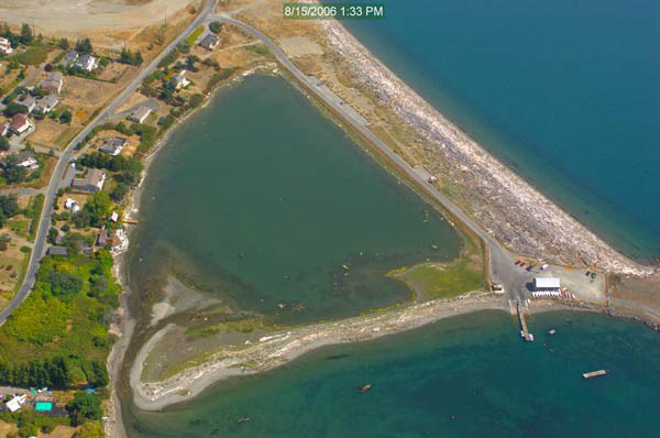
Argyle Lagoon, San Juan Island, with tidal creek entrance on the left. Image © State of Washington Department of Ecology, Digital Coastal Atlas, August 15, 2006. The undeveloped property on the lower left-hand side of the image is the upland portion of the Preserve.
This is a 14 acre property that includes all of the Argyle Lagoon tidelands (12.3 acres classified as “oysterlands” by the State) including part of a tidal creek, and a 1.7 acre upland parcel that borders on Argyle Lagoon as well as on Pear Point Road. The University of Washington leased Argyle Lagoon from 1965, purchased the property in 1984, and now manages Argyle Lagoon as one of the five Washington State Department of Fish and Wildlife (WADFW) fisheries preserves established in 1990, known collectively as the “San Juan Islands Biological Preserves.” Argyle Lagoon is easily accessed by car from Jackson Beach Road off Pear Point Road. The adjacent beaches (North Bay beach off Griffin Bay - lower right in above photo, and Jackson Beach - upper right in above photo) are owned by the Port of Friday Harbor and see quite a bit of recreational use.
The Argyle Lagoon Biological Preserve is closed to the take of fish and shellfish except for research. Argyle Creek and Argyle Lagoon are frequently visited by UW Friday Harbor Labs biology classes and are usually the site of several ongoing research projects.
**
This page is maintained by C.E. Mills; established 20 October 2008;
last updated 26 September 2014 **
University of Washington San Juan Islands Biological Preserves
Friday
Harbor Laboratories | Plant inventory for FHL uplands
Centennial Historical Timeline
of the Friday Harbor Labs
Mills Home | Marine
Research Study Sites in the San Juan Islands